Harborough Local Plan 2011-2031, Proposed Submission
Part A Strategy and General Policies
1 Introduction
1.1 What is the Local Plan?
1.1.1 The National Planning Policy Framework (NPPF) requires every local planning authority to have a clear, up to date local plan, which will help to deliver sustainable development, conform to the NPPF, meet development needs, and reflect local aspirations.
1.1.2 The Harborough Local Plan provides an important strategy for Harborough District. It will play a significant role in delivering sustainable development in appropriate locations and in helping to protect the countryside, important green spaces, and the built and natural heritage from inappropriate or insensitive development, thus enhancing the quality of life for people and communities.
1.1.3 The Local Plan entirely replaces:
- Harborough District Local Development Plan Core Strategy 2006-2028 (adopted in 2011); and
- Harborough District Local Plan 2001 (Retained Policies).
1.1.4 Appendix A Relationship to Core Strategy and other Saved Policies sets out how the policies in these plans have been replaced by the policies in this Local Plan.
1.1.5 The Local Plan explains how much and what types of development will take place, where it will be built and how and when it will be delivered. The Local Plan also identifies any additional infrastructure (such as new roads and schools) which is needed to support development and explains how this supporting infrastructure will be delivered.
1.1.6 The Local Plan provides an overall vision for the District, a number of specific objectives and a detailed set of policies to explain how the vision and objectives will be achieved, together with a Policies Map which shows where policies apply.
1.1.7 The Harborough Local Plan, along with 'made' neighbourhood plans and adopted minerals and waste plans, forms the overall development plan for Harborough District. An up to date list and further information concerning these plans can be found in the Harborough District Local Development Scheme, available on the Council's website (see Appendix B Supporting evidence).
1.1.8 The Local Plan is the starting point for considering whether planning applications (apart from for minerals and waste development) can be approved. Decisions on planning applications will be taken in accordance with its policies, unless material considerations indicate otherwise. The Local Plan covers a range of issues and it is likely that several policies will be relevant to any given proposed development. It is important therefore that the plan is read as a whole rather than treating policies in isolation.
1.2 How has the Local Plan been prepared?
1.2.1 The Harborough District Local Plan has been prepared taking account of:
- national planning policy as set out in the NPPF, various planning acts and ministerial statements, together with related guidance, especially Planning Practice Guidance;
- evidence studies prepared to inform the Local Plan; and
- ongoing and proactive stakeholder engagement throughout
the preparation of the Local Plan, including responses to the
following public consultations:
◦ Scoping consultation - This first consultation gathered the views of interested parties on the proposed contents of the new Local Plan. These views were used to finalise the scope of the Plan and to inform the identification of any further evidence requirements. The scoping consultation took place in March and April 2013.
◦ Options consultation - This consultation sought views on 9 alternative options for locating housing and employment, together with other proposed policy approaches. The alternative options consultation took place in September – October 2015.
1.2.2 Further information concerning each of these is available online by following the link set out in Appendix B Supporting evidence.
1.3 What area does the Local Plan cover?
1.3.1 The Local Plan relates to the whole of Harborough District as depicted in Fig A.1 below and described in more detail in Appendix D Spatial Portrait.
1.3.2 The Local Plan may be supplemented by more detailed policies and proposals in neighbourhood plans where these are prepared for parts of the District.
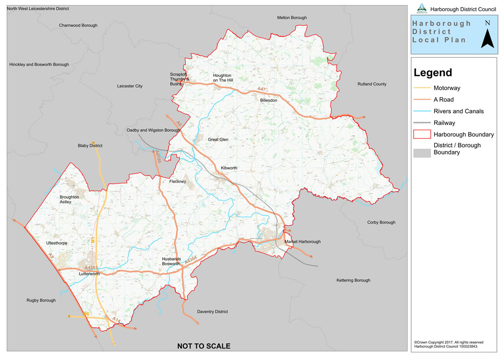
Fig. A.1 Harborough District and Neighbouring Authorities
1.4 How does Harborough relate to neighbouring places?
1.4.1 Harborough District cannot be viewed in isolation from adjoining areas. Fig. A.1 shows the local authorities which neighbour Harborough District. Harborough has had a particularly strong relationship with Leicester and the rest of Leicestershire. It is dependent on the Leicester urban area not only for the significant amount of employment located there, but also for higher order health, retail and cultural facilities and services. Therefore, the regeneration and economic well-being of the Leicester urban area is an important consideration in any future strategy for the District.
1.4.2 The District lies within the Leicester and Leicestershire Housing Market Area (HMA) and Functional Economic Market Area (FEMA), which both cover the whole of Leicester and Leicestershire. These have been defined in recognition of the central economic role of Leicester and the fact that people travel to work and move house across local authority boundaries within this area. The Leicester and Leicestershire HMA and FEMA are shown in Fig. A.2 below. (Fig. A.2)
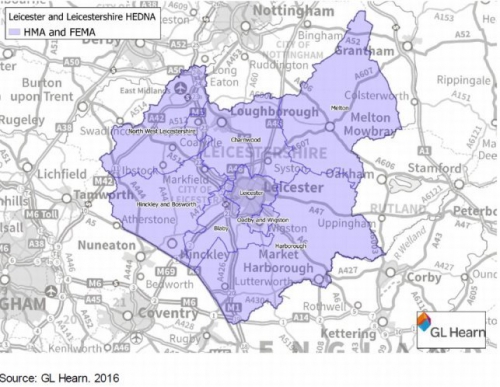
Fig. A.2 Leicester and Leicestershire HMA and FEMA
1.4.3 The nine Leicestershire local authorities and the Local Enterprise Partnership (LEP) have worked together to prepare the Leicester and Leicestershire Housing and Economic Development Need Assessment (HEDNA) 2017 as part of their Duty to Cooperate responsibilities (see section 1.5 below). This important study informs the quantity of housing and employment land provision that the Local Plan provides for.
1.5 The Duty to Cooperate
1.5.1 The Duty to Cooperate was established in the Localism Act 2011, which amended the Planning and Compulsory Purchase Act 2004. It places a legal duty on local planning authorities, county councils and public bodies to engage constructively, proactively and on an ongoing basis to ensure that significant issues that affect more than one local authority area are addressed adequately within plans. This Harborough Local Plan must therefore consider influences on and the requirements of adjoining areas and how strategic infrastructure is to be delivered.
1.5.2 Whilst the NPPF (paragraph 156) sets out examples of strategic planning issues where cooperation might be appropriate, it is up to individual local authorities to compile their own list to reflect local circumstances. As part of its Duty to Cooperate, the Council has actively engaged with its strategic partners on an agreed range of strategic priorities throughout the preparation of the plan. Details of how the Council has undertaken and met the Duty to Cooperate requirements are set out in a separate Duty to Cooperate Statement, 2017.
1.5.3 The following strategic priorities for the Local Plan have emerged from liaison with the prescribed bodies:
(9) SP1: Meeting the housing and employment needs of the Leicester and Leicestershire housing and economic market areas.
(5) SP2: Assisting other local authorities to meet their unmet housing need.
(4) SP3: Meeting regional and national demand for strategic distribution (logistics) development.
(2) SP4: Meeting the accommodation needs of Gypsies and Travellers.
(3) SP5: Providing transport and other infrastructure to support new development.
(2) SP6: Providing for strategic green infrastructure (i.e. Green Wedges).
(1) SP7: Protecting and enhancing biodiversity and geodiversity.
(1) SP8: Providing for retail needs.
(2) SP9: Minimising flood risk.
(1) SP10: Safeguarding land needed for minerals and waste.
1.5.4 The councils within Leicester and Leicestershire, with the Leicester and Leicestershire Local Enterprise Partnership as an observer, are preparing a Leicester and Leicestershire Strategic Growth Plan. This will outline the amount and location of future growth in Leicester and Leicestershire from 2031 to 2036 and will set out broad aspirations for growth up to 2050. A Strategic Growth Statement was published in August 2016, which set out the basis for preparing the Strategic Growth Plan. When completed, the Strategic Growth Plan will be a non-statutory document in planning policy terms, but will be the context for future reviews of this Local Plan, as described in Policy IMR1 Monitoring and review of the Local Plan. Its emerging strategy has been taken into account in preparing this Local Plan but it does not directly impact on its policies to 2031.
1.6 Neighbourhood planning
1.6.1 The Government has given local communities new rights to shape their neighbourhood through the preparation of neighbourhood plans. Once made neighbourhood plans form part of the Development Plan and have the same status as this Local Plan in making decisions on planning applications.
1.6.2 There has been a high level of community interest and engagement in the preparation of neighbourhood plans, with almost a third of parish councils across the District leading on their preparation. The Council anticipates that the coverage of neighbourhood plans will continue to increase across the District over the plan period.
1.6.3 The Council is committed to working positively with local communities where they wish to develop a neighbourhood plan and to supporting them through the statutory processes. This includes ensuring that neighbourhood plans are in general conformity with strategic policies, as set out in this Harborough Local Plan, together with minerals and waste local plans, and helping to avoid duplication of local policies.
1.6.4 Neighbourhood plans will have an important role in bringing forward local housing sites as described in Policies SS1 The spatial strategy and H1 Provision of new housing.
1.6.5 Neighbourhood plans should be in general conformity with the strategic policies in this Local Plan. National Planning Practice Guidance states that, when reaching a view on whether a policy is a strategic policy, the following are useful considerations:
- whether the policy sets out an overarching direction or objective;
- whether the policy seeks to shape the broad characteristics of development;
- the scale at which the policy is intended to operate;
- whether the policy sets a framework for decisions on how competing priorities should be balanced;
- whether the policy sets a standard or other requirement that is essential to achieving the wider vision and aspirations in the Local Plan;
- in the case of site allocations, whether bringing the site forward is central to achieving the vision and aspirations of the Local Plan;
- whether the Local Plan identifies the policy as being strategic.
1.6.6 Having given consideration to these factors, the Council is of the view that almost all the policies in this Local Plan meet some or all of these criteria and are therefore strategic. The exceptions to this are:
- GD6: Areas of Separation
- GD9: Minerals Safeguarding Areas
- H3: Rural exception sites
- RT3: Shopfronts and advertisements
- HC2: Community facilities
- HC3: Public houses, post offices and village shops
- GI3: Cemeteries
- GI4: Local Green Space
- CC4: Sustainable drainage.
1.6.7 With the exception of these policies, neighbourhood plans should be in general conformity with all polices of this Local Plan.
1.7 Supplementary Planning Documents
1.7.1 Supplementary Planning Documents (SPDs) add further detail to policies in the Local Plan. They can be used to provide further guidance for development on specific sites or on particular issues, such as design. SPDs are capable of being a material consideration in planning decisions but are not part of the Development Plan.
1.7.2 The Planning Obligations SPD was adopted by the Council in September 2016 and published in January 2017. It sets out the circumstances in which planning obligations will be sought to meet additional infrastructure and affordable housing needs arising from new developments.
1.7.3 In addition, a number of other SPDs and Supplementary Planning Guidance Notes have been adopted by the Council, the majority of which are linked to policies in the previous Local Plan (2001). However, some of the detailed design principles contained within the documents are still relevant and valuable in giving guidance to applicants and in the determination of planning applications. As a result, the Council's Executive resolved on 19 December 2011 that existing guidance, where still relevant, should continue to be used as a material consideration in determining planning applications.
1.7.4 The Council may also set out proposals for new SPDs in its Local Development Scheme (see Appendix B Supporting evidence).
1.8 Structure of the document
Part A Strategy and General Development policies
1.8.1 This includes the Introduction to the Local Plan, explaining its role and purpose. The Key Issues and Objectives of the Plan flow from the Spatial Portrait (see Appendix D) and Vision and provide the overall aims of the policies that follow.
1.8.2 SS1 The spatial strategy sets out the overall strategy for the District during the plan period to 2031 and explains how development needs will be met.
1.8.3 Chapter 4 General development policies apply to all development proposals as appropriate and relevant.
Part B Key Topics
1.8.4 This includes policies relating to the following key topics: housing; business and employment; retail, town centres and tourism; heritage and community assets; green infrastructure; climate change; infrastructure; and implementation, monitoring and review.
Part C Places and Sites
1.8.5 This provides a site-specific policy for each of the sites allocated within the Local Plan for either housing or employment uses. It also includes policies L1 East of Lutterworth Strategic Development Area and SC1 Scraptoft North Strategic Development Area to manage the development of these SDAs.
Appendices
1.8.6 These contain important information to support the Local Plan.
Users of the Local Plan should note that, the Local
Plan must be read as a whole. More than one
policy is likely to be relevant for each development
proposal.
2 Vision and objectives
(16) 2.1 Local Plan vision
2.1.1 The Local Plan vision explains how the Harborough District will change and develop over the plan period to 2031. It sets out a collective positive vision for the future of the area, as required by the National Planning Policy Framework (NPPF).
In 2031, Harborough District will be a vibrant, safe and prosperous place which retains its identity as a predominantly rural area of villages and market towns where local communities enjoy a high quality of life. Residents will benefit from increased access to suitable housing, a wider range of local skilled jobs, and high quality services and facilities, all of which promote healthy and safe lifestyles.
The District will have a diverse and thriving economy, with market towns and some large villages acting as employment and service centres for their surrounding rural areas. The diversity and quality of Harborough's countryside, natural and historic environment will have improved for the benefit of residents and visitors. Air and water quality will have been improved while the impacts of noise and light pollution will have been minimised. There will be better access to the countryside and an improved range of open spaces for local people to enjoy.
By 2031 the District will have improved resilience to the impacts of climate change, with new development located in areas of low flood risk and incorporating energy efficient design and sustainable drainage systems (SuDs) to manage run-off water sustainably. Low carbon design techniques and technologies, increased provision for walking and cycling, and improved access to public transport for new development will have contributed to a reduction in the District's carbon footprint.
New development will have been delivered in the most sustainable locations. The historic market town of Market Harborough will have retained its character and strengthened its role as the District's principal town. The impact of heavy goods vehicles and traffic more generally on noise and air pollution in Lutterworth town centre will have been reduced and the environmental quality of the town centre improved, thereby enabling its historic core to be enhanced and appreciated more fully.
These two market towns, along with settlements near to the edge of Leicester (Scraptoft, Thurnby and Bushby), Broughton Astley and the rural centres, will have been the main focus for development. Residential development will have been delivered to meet strategic and local needs and the necessary infrastructure and community facilities needed to support this growth will have been delivered on time. Selected rural villages will have seen small-scale, sensitively located development to support local objectives, meet local housing needs and sustain village services. In the wider countryside only very limited development will have taken place to meet specifically identified housing needs and support long-term rural sustainability.
The economic base of the District will have been strengthened through the fostering of new enterprise and the sustainable growth of existing businesses. Supporting infrastructure will be in place to allow businesses to grow. The District will have full high speed broadband coverage benefiting businesses and local residents.
Strategic distribution sites will have adapted to the changing needs of the sector and maintained their significance to the District and the wider area in terms of employment provision.
New housing will reflect local needs in terms of type, size and tenure and enable equality of access to suitable accommodation. Older people will have increased access to accommodation to suit their changing needs and affordable homes will have been delivered to enable a new generation of home owners to get onto the housing ladder and to meet the needs of those unable to afford market housing for sale. New housing developments will be high quality, well designed, and respectful of their setting in order to ensure that the character of the District's towns and villages is maintained and protected.
Communities will have access to improved social, recreational, sports, health and educational facilities. Existing valued community services will have been retained and necessary new ones delivered to keep pace with development. The design of the public realm will have responded to the needs of the elderly, young and other vulnerable sections of the community, thereby assisting in a sense of inclusiveness and well-being for all residents.
Communities across the District will have embraced neighbourhood planning, affording them the opportunity to shape the future of their environment by ensuring that they have a real stake in the decision making processes that oversee what development takes place and where.
2.2 Key Issues
2.2.1 The following key issues have emerged from the the Local Plan Vision, as well as from evidence studies, strategies and previous consultations, in particular:
- Harborough District Council Corporate Priorities;
- Harborough Economic Strategy, 2016;
- strategic priorities identified through the Duty to Cooperate process (see section 1.5);
- Leicester and Leicestershire Housing and Economic Development Need Assessment (HEDNA) 2017;
- consultation responses received on the vision and objectives as part of the Local Plan Options Consultation Paper, 2015;
- the social, economic and environmental profile of the District (see Appendix D Spatial Portrait);
- the sustainability assessment process.
(4) Key issue 1: The spatial strategy for distribution of housing and employment development
- determining an appropriate distribution of housing and employment growth that takes account of strategic growth locations, the settlement hierarchy, and the ability to provide essential utilities and infrastructure, whilst safeguarding local heritage and sensitive landscapes.
(4) Key Issue 2: Meeting housing needs
- establishing and meeting the objectively assessed housing needs and land requirements for the District to 2031 with sufficient flexibility in provision to ensure that the Government's 5 year housing land supply requirements can be met in future;
- addressing the problems of high house prices by providing a wider range of housing types/tenures, including affordable homes and suitable homes to meet the needs of an ageing population;
- making an appropriate contribution to meeting the established and justified unmet housing needs of other authorities within the Leicester and Leicestershire housing market area;
- identifying suitable, available and deliverable sites which can meet the District's housing needs in a sustainable manner that is complementary to the distribution of planned business development.
(5) Key issue 3: Facilitating growth in the economy
- allocating sufficient land for business uses to meet employment growth in the District to 2031 in a way that is complementary to the amount and distribution of planned housing growth whilst also contributing significantly to wider sub-regional land requirements for road-based strategic distribution business space;
- reducing the dependence of Harborough's residents on commuting and increasing wage rates by providing a breadth of employment alternatives, including more opportunities for Harborough's higher skilled residents, through resisting the loss of 'fit for purpose' employment space, and encouraging the refurbishment of existing and delivery of new employment space to support inward investment and the growth of existing businesses;
- addressing areas of rural disadvantage, service loss and isolation by encouraging rural diversification and land-based businesses and safeguarding and encouraging the provision of additional village services and facilities.
(3) Key issue 4: Development in the countryside
- restricting inappropriate development in the countryside whilst promoting rural diversification.
(3) Key issue 5: Green infrastructure
- addressing the biodiversity deficit in the District through the provision of multifunctional greenspace that includes a range of habitats and linkages to established habitats, as part of all new development;
- safeguarding the recognised areas of high biodiversity and geodiversity.
(4) Key issue 6: Climate change
- addressing the risk of flooding from rivers, surface water and groundwater to both new development and established communities through the location of new development and ensuring green infrastructure includes sustainable drainage systems (SuDs) that also contribute to improved water quality in the District's watercourses and biodiversity improvements;
- ensuring that the District is resilient to changes in climate by encouraging building design that minimises carbon emissions through maximising use of renewable energy and connections to decentralised networks, stores and reuses rainwater, remains comfortable in hot and cold weather, and is resilient to the increasing risk of flooding from any source.
(5) Key issue 7: Town centres and retail
- maintaining, and where possible improving, the vitality and viability of the service centres in the District, so reducing the need to travel, while preserving, and where possible enhancing, the predominantly rural character of the District;
- sustaining the strength of town centres against the threat of 'leakage' to other centres and use of on-line shopping, realising rural vitality and making appropriate retail provision in Market Harborough, the Key Centres and local centres.
(5) Key issue 8: Transport
- addressing road infrastructure constraints affecting the Leicester urban fringe and South West Leicestershire, and traffic congestion affecting Lutterworth and The Kibworths to relieve congestion, aid vitality and viability and support the movement of people and goods;helping to improve air quality, especially in Air Quality Management Areas, whilst at the same time encouraging and making provision for sustainable travel choices to reduce reliance on the private car.
- ensuring essential infrastructure, including high speed broadband and telecommunications to meet the needs of new and existing communities, is identified, secured and made available in a timely manner to support sustainable housing and employment growth.
(1) Key issue 10: Gypsy and Traveller, and Travelling Showpeople
- addressing the needs of Gypsy, Traveller and Travelling Showpeople communities by providing suitable accommodation to meet the needs of these communities.
2.3 Local Plan objectives
2.3.1 These objectives have been identified as central to the delivery of the vision for the District and are the guiding principles for the policies set out in the Local Plan. The 14 objectives set out below are intended to address the strategic priorities (paragraph 1.5.3), deliver the Local Plan Vision (section 2.1) and deal with the key issues (section 2.2). Appendix E Local Plan objectives gives detail regarding which Local Plan policies address the objectives and the links to relevant key issues and strategic priorities.
(1)
Objective 1.
Housing: Meet the housing requirements of the
District in full by providing a range of market and
affordable housing types, tenures and sizes in appropriate
and sustainable locations to meet local needs. Recognise
the specific accommodation requirements of the young and
the elderly populations, including starter homes to help
first time buyers, shared ownership and rented housing to
help those who cannot afford to buy, and specialist housing
such as sheltered and extra care accommodation.
(3)
Objective 2.
Employment: Promote sustainable economic growth by
facilitating the sustainable growth of businesses,
fostering new local enterprise and helping to create more
jobs that meet local employment needs. Contribute to
reducing the need for out-commuting and thereby help to
increase the sustainability and self-containment of
communities, while encouraging the development of a
vibrant, diverse and sustainable business community.
Objective 3. Location
of development: Locate new development in
sustainable locations that respect the environmental
capacity of the local area. Encourage the appropriate and
efficient re-use of previously developed land and buildings
where such re-use achieves the objectives of sustainable
development.
(2)
Objective 4.
Infrastructure: Support local communities and
maintain a high quality of life by ensuring that new
development delivers the necessary infrastructure including
that relating to health, education, security, culture,
transport, open space, recreation, water supply and
treatment, power, waste and telecommunications
(incorporating high speed broadband connectivity).
Objective 5.
Protection of local services: Protect, enhance
and, where appropriate, secure the provision of additional
accessible community services and local facilities,
supporting innovation in their delivery across the
District.
(3)
Objective 6. Natural
environment: Protect, maintain, restore and
enhance the quality, diversity, character, local
distinctiveness, biodiversity and geodiversity of the
natural environment, creating links between wildlife sites
ensuring that open countryside is protected against
insensitive and sporadic development, the characteristics
of the local landscape are respected and the unnecessary
loss or sterilisation of natural resources is
prevented.
(4)
Objective 7.
Historic environment: Protect and enhance
the character, distinctiveness and historic significance of
settlements and their wider landscape and townscape
settings, thereby recognising the important contribution
that heritage assets and their settings make to securing a
high quality public realm and supporting tourism and the
economy.
(1)
Objective 8.
Town/village centres: Support and enhance the
vitality and viability of market town and larger village
centres as places for shopping, leisure, cultural,
commercial and community activities, thereby recognising
and embracing their valued role as the hearts of their
communities. This will be achieved by encouraging retail,
leisure and commercial development in appropriate locations
and at appropriate scales.
(2)
Objective 9.
Design: Ensure that new development is of high
quality and sustainable design which reflects local
character and distinctiveness, provides attractive, healthy
and safe environments, respects residential amenity and
promotes sustainable behaviours including renewable energy
technologies, and waste reduction.
(4)
Objective 10.
Transport: Provide greater opportunities to reduce
car use, thereby reducing the impacts of road traffic on
local communities, the environment and air quality, by
locating development where there is good access to jobs,
services and facilities, and by supporting improvements in
public transport, walking and cycling networks and
facilities.
(3)
Objective 11. Flood
risk: Locate new development in areas which will
not put life or property at risk of flooding and build
associated resilience by requiring the use of appropriate
sustainable drainage systems in new developments and
allowing for the provision of infrastructure associated
with minimising flood risk, including in relation to future
risk from climate change.
(1)
Objective 12.
Environmental impact: Minimise the environmental
impact of development and its vulnerability to the impacts
of climate change, by reducing pollution and waste as much
as possible, maximising water and energy efficiency, and
promoting the use of low carbon, renewable energy, and
other alternative technologies, with sustainable
construction methods.
Objective 13. Tourism
and Culture: Promote the sustainable growth of
tourism, cultural activities and access to the countryside
for the benefit of both residents and visitors. Enable the
interpretation of the cultural assets of the District in
order to enrich people's experiences.
(2)
Objective 14:
Neighbourhood Planning: Encourage and support
communities to make decisions at the local level through
the preparation of neighbourhood plans and facilitate this
process by setting out a clear strategic framework.
3 Sustainable settlements
SS1 The spatial strategy
The spatial strategy for Harborough District to 2031 is to:
(13) 1. manage planned growth to direct development to appropriate locations, in accordance with the following settlement hierarchy:
(3) a. (part of) the Leicester Principal Urban Area: Scraptoft, Thurnby and Bushby;
(1) b. Sub-regional Centre: Market Harborough;
(5) c. Key Centres: Lutterworth, Broughton Astley;
(5) d. Rural Centres: Billesdon, Fleckney, Great Glen, Houghton on the Hill, Husbands Bosworth, The Kibworths, Ullesthorpe;
(8) e. Selected Rural Villages: Bitteswell, Church and East Langton, the Claybrookes, Dunton Bassett, Foxton, Gilmorton, Great Bowden, Great Easton (with Bringhurst), Hallaton, Lubenham, Medbourne, North Kilworth, South Kilworth, Swinford, Tilton on the Hill, Tugby;
(3) f. Other villages, rural settlements and the countryside where development will be strictly controlled.
2. enable housing and commercial development, during the period 2011- 2031, including:
(12) a. Housing: provision of land for a minimum of 12,800 dwellings (Use Class C3), including:
i. about 7,915 dwellings already completed or committed, including through planning permissions, resolutions to grant permission and allocations in made neighbourhood plans;
(2) ii. about 1,500 dwellings in a strategic development area (SDA) on land east of Lutterworth ;
(5) iii. about 1,200 dwellings in a SDA at Scraptoft North;
iv. about 1,170 dwellings on other sites allocated in this Local Plan;
(4) v. about 790 dwellings on non-allocated sites or sites to be allocated in neighbourhood plans for Rural Centres and Selected Rural Villages;
(2) vi. about 225 dwellings on windfall sites outside Rural Centres and Selected Rural Villages.
(2) b. Business: safeguard important existing employment areas, identify sites to meet future economic development needs and replace losses in the stock of employment land for offices (B1(a) and (b)), industry (B1(c) and B2) and non-strategic storage and distribution (B8) as follows:
i. about 16.5 hectares of employment land already completed or committed, including through planning applications, resolutions to grant permissions and allocations in made neighbourhood plans;
(2) ii. about 23 hectares of employment land in the East of Lutterworth SDA;
iii. about 35.5 hectares of employment land on other sites allocated in this Local Plan.
(6) c. Strategic storage and distribution: safeguard existing provision at Magna Park and ensure further sites contribute towards meeting the future requirement for non rail-served land across Leicester and Leicestershire in accordance with Policy BE2.
i. about 4,300 sq.m. gross sales area of convenience shopping, of which about 3,100 sq.m. should be in Market Harborough and 1,000 sq.m. in Lutterworth, within the East of Lutterworth SDA;
ii. about 10,100 sq.m. gross sales area of comparison shopping (A1), of which about 8,000 sq.m. should be in Market Harborough and 1,500 sq.m. in Lutterworth (including within the East of Lutterworth SDA).
(2) 3. bring forward strategic development areas at East of Lutterworth and Scraptoft North and ensure that they become well-planned, high quality living environments and that they support the maintenance and improvement of employment areas, shopping centres and community facilities both within them and nearby;
(3) 4. ensure that the quantity and location of development within or adjoining the Leicester Principal Urban Area safeguards the identity of the communities of Scraptoft and Thurnby/Bushby and supports regeneration and development objectives in the neighbouring City of Leicester and Oadby and Wigston Borough;
(2) 5. consolidate Market Harborough's role as a focus for development within the District, subject to traffic and environmental constraints, while promoting its historic function as a market town and safeguarding its compact and attractive character;
(1) 6. maintain and improve the character and environment of the market town of Lutterworth and develop Broughton Astley, both as Key Centres providing housing, business, retail, leisure, and community facilities to serve each settlement and its catchment area;
(3) 7. enable Fleckney, Great Glen, and The Kibworths and, to a lesser extent, Billesdon, Houghton on the Hill, Husbands Bosworth, and Ullesthorpe to operate as Rural Centres providing housing, business, retail, leisure, and community facilities to serve their needs and those of surrounding areas;
(1) 8. meet local needs in Selected Rural Villages, while protecting the character and environment of local areas; and
(1) 9. strictly control development in the countryside and on designated open space within all settlements.
(2) 3.1 SS1 Explanation
3.1.1 The evidence base has identified the need for new housing, employment, and retail developments over the period up to 2031. Policy SS1 sets out the scale of new development required to meet the Local Plan Objectives. The policy sets the overall framework for the rest of the Local Plan, setting out the proposed scale and distribution of new development by reference to existing and emerging growth plans for the sub-region of Leicester and Leicestershire and to the existing hierarchy of settlements within the District, with a focus on those at the higher levels of the hierarchy. Development in these locations will support identified growth areas and critical economic corridors and help to avoid the need for unnecessary journeys, thus limiting car usage and carbon emissions, while possibly enhancing and protecting local services. The main features of the strategy are illustrated in the Key Diagram (Fig. A.3.).
(1) Strategic Documents
3.1.2 Following revocation of the East Midlands Regional spatial strategy in 2013, strategic growth in Leicester and Leicestershire, especially infrastructure provision, has been guided by the Strategic Economic Plan (SEP). The SEP is the key overarching growth strategy that sets out how the Leicester and Leicestershire Economic Partnership (LEP) intends to bring together the European Structural and Investment Fund (ESIF) Strategy, City Deal and Growth Deal to build on the region's competitive advantages and tackle the major risks to its economy. The SEP provides the framework for achieving the LEP's vision by investing in Place, Businesses and People. It aims to unlock development sites and improve public realm and connectivity to enable the efficient transport of people and goods. It defines five growth areas where infrastructure investment will be prioritised, including the Leicester Urban Area and South West Leicestershire which covers Lutterworth and the M1 and A5 corridors. The SEP (which runs to 2020) is to be refreshed but is expected to maintain the same growth areas.
3.1.3 The Midlands Connect Partnership was established in 2014 and is a pan-Midlands grouping of local transport authorities, local enterprise partnerships, local business representatives, and the Department for Transport with its key delivery bodies which now forms the transport component of the Midlands Engine for Growth.
3.1.4 Midlands Engine for Growth was published in March 2017, linked to the national Industrial Strategy. Midlands Engine is a long term investment strategy covering the area from Shropshire to Lincolnshire the M1 and the M6. Its aim is to promote growth in the Midlands at the heart of the UK economy. Midlands Engine has a five key themes: promote the area nationally, support delivery of Midlands Connect, promote innovation, provide finance for business, and encourage skills. (Fig. A.3)
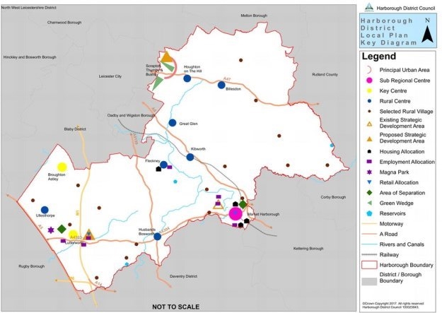
Fig. A.3 Harborough District Local Plan Key Diagram
3.1.5 The Leicester and Leicestershire Strategic Growth Plan (SGP) will build on the transport strategy already prepared for the Midlands Engine and Midlands Connect strategies. It is an overarching plan which will set out the aspirations for delivering growth (housing, economic and infrastructure) in Leicester and Leicestershire until 2050. The aim of the Strategic Growth Plan is to help realise the opportunities and manage the risks of growth and to overcome the challenges experienced by existing communities and create high quality developments with supporting infrastructure across the LEP area. A consultation relating to a Strategic Growth Statement was undertaken in Summer 2016 on the high level plan objectives, options for growth and evidence requirements. It is anticipated that further public engagement will take place on the development of the SGP in late 2017.
(4) The Settlement Hierarchy
3.1.6 The settlement hierarchy identifies the settlements which are most suitable in sustainability terms to meet the development needs of the District to 2031. It provides the framework from which the spatial strategy has evolved and sustainable development can be realised across the District to 2031. This is set out in more detail in Appendix F The settlement hierarchy.
3.1.7 At the top of the hierarchy is the whole built-up area of Leicester, including the City and parts of adjoining local authority areas that are physically joined to it, known as the Leicester Principal Urban Area (PUA). Within Harborough District this includes the suburbs that have been developed over many years centred on the historic villages of Scraptoft, Thurnby and Bushby. This area enjoys relative ease of access to the range of higher order health, education, cultural and retail services and employment opportunities available within Leicester City and is well suited to meet housing needs arising from the City. It already has 950 new housing completions (since 2011) and commitments and is proposed for a further 1,200 homes, many of which may be needed to help deal with meeting unmet needs arising from another local authority under the duty to cooperate.
3.1.8 At the next level in the hierarchy is Market Harborough, a Sub-Regional Centre which was the focus of growth set out in the 2011 Harborough District Core Strategy to 2028. It is relatively self-contained with a wide range of services, facilities, shops and employment opportunities and good public transport links. It is a good location for development but is already committed to receiving about 1,500 new homes in the Market Harborough Strategic Development Area to the north-west of the town, with a similar number of completions (since 2011) and commitments elsewhere in the town. It also has about 9.5 hectares of land permitted for employment uses. Given these commitments, further development is limited to approximately 1,040 dwellings on three major housing sites, some homes elsewhere in the town, a 13 hectare allocation for employment within the SDA and the completion of employment sites that have previously been allocated.
3.1.9 Lutterworth and Broughton Astley are identified as Key Centres. Although similar in size, Lutterworth has a much wider range of services, facilities, shops and employment than Broughton Astley, and benefits from direct access to the M1. Magna Park, a large strategic distribution/logistics development, lies just to the west of the town providing employment opportunities in addition to the many within the town itself. Lutterworth is therefore an appropriate location for significant housing and employment development to meet a large part of the District's requirement. Policy SS1 proposes that a Strategic Development Area (SDA) be allocated on land east of Lutterworth to deliver around one third of the District's requirement for new dwellings as well as further dwellings after the plan period, between 2031 and 2036. It also proposes 23 hectares of employment land.
3.1.10 Broughton Astley was first identified as a Key Centre in the 2011 Harborough Core Strategy with the aim of broadening its retail, service and employment provision. A neighbourhood plan has been made which identified suitable sites and planning consents are now in place for retail and employment uses. The neighbourhood plan also allocates more than enough housing land to meet its needs.
3.1.11 Rural Centres are identified as a focus for rural development, to serve both the settlements themselves and the surrounding rural area. The size of these settlements, and level of services and facilities within them varies considerably. Fleckney, The Kibworths and Great Glen are the largest with significant village centres offering a range of shops and services. Fleckney has substantial employment provision. The Kibworths benefit from a secondary school. Great Glen is relatively close to the PUA and its higher order services, facilities and employment. Billesdon, Houghton on the Hill, Husbands Bosworth and Ullesthorpe are smaller settlements with a more limited range of services. Focusing rural development in these villages will help to support existing facilities and provide a focal point for use by residents of surrounding smaller villages and hamlets.
3.1.12 Whilst Rural Centres will be the main focus for development in rural areas, villages with access to at least two of the six key services (as described in Appendix F) have been identified as Selected Rural Villages. These are sustainable locations for more limited growth that will help to sustain these villages.
3.1.13 Paragraph 55 of the National Planning Policy Framework (NPPF) makes it clear that development in rural areas should be located where it will enhance or maintain the vitality of rural communities and this can include development in one village supporting services in a village nearby. Adopting this approach, the settlement hierarchy has grouped together neighbouring villages which share a primary school within acceptable, safe walking distance as composite Selected Rural Villages (Church and East Langton, the Claybrookes, and Great Easton with Bringhurst).
3.1.14 Rural villages and other settlements which do not meet the criteria for identification as Selected Rural Villages are not considered sustainable locations for development and are at the bottom of the settlement hierarchy. They are considered countryside and proposals and will be assessed against policies GD3 Development in the Countryside and GD4 New Housing in the Countryside.
(1) NPPF Context
3.1.15 Policy SS1 meets several core principles of the NPPF (paragraph 17), including:
- being plan-led;
- empowering people through neighbourhood plans;
- creating and enhancing places;
- pro-actively driving and supporting sustainable development;
- promoting the vitality of main urban areas;
- recognising the intrinsic nature of the countryside while supporting rural communities;
- promoting mixed use development; and
- actively managing patterns of growth to focus significant development in locations which are, or can be made, sustainable.
3.1.16 Furthermore, in relation to rural areas, the NPPF is clear that, in order to promote sustainable development, housing should be located where it will enhance or maintain the vitality of rural communities, that new rural housing should not only address housing supply and affordability issues but also support the broader sustainability of villages, and that all settlements can play a role in delivering sustainable development in rural areas.
3.1.17 The NPPF also states that local plans should meet objectively assessed needs unless there would be significant adverse impacts. Key evidence to assess housing and economic development needs has come from the Leicester and Leicestershire Housing and Economic Development Need Assessment (HEDNA), 2017, the Strategic Housing Land Availability Assessment (SHLAA), 2016 and the Strategic Employment Land Availability Assessment (SELAA), 2017.
How the spatial strategy was arrived at
3.1.18 The distribution of development, particularly in relation to housing, was selected from a wide range of reasonable alternatives. The Options Consultation Document, 2015 contained 9 different options and combinations of options, although even these were actually greater since there were two different options for a Strategic Development Area (SDA) at The Kibworths while the site for a proposed Strategic Development Area in Scraptoft/Thurnby was amended after the Options Consultation by a further proposal for a SDA at Scraptoft North. Following consultation on the original 9 options, a comprehensive analysis of the latest proposals, including the proposed Scraptoft North SDA was undertaken looking at the available evidence relating to the following factors:
- Consultation – assessing the key issues raised during the Options Consultation in relation to each of the 9 Options;
- Deliverability, comprising evidence on Land Availability, Infrastructure, and Viability; and
- Planning Principles, comprising an assessment against Sustainability (using evidence from the Sustainability Appraisal (SA) Interim Report, September 2015), NPPF Core Principles and Local Plan Objectives.
3.1.19 This resulted in the identification of four Selected Options which were subject to the collection of further more detailed evidence and to a further assessment based on that evidence, looking at the following factors:
- Transport - including peak hour traffic impacts, network stresses in south-east Leicester, accessibility by sustainable transport, and transport benefits.
- Deliverability - covering housing land availability, marketability, infrastructure constraints and costs, viability, ownership issues and longer term potential.
- Environmental factors - flood risk; landscape capacity; SA assessment of: built heritage, natural environment, and resource use, and climate change mitigation.
- Socio-economic factors - location in relation to housing need; proximity to and provision of employment, retail, education and community facilities; SA assessment of effects on housing, economy, health and well-being; open space provision; Gypsy and Traveller provision; and air quality impacts.
- Planning principles - re-assessment against NPPF Core Principles.
3.1.20 The outcome of this was to identify a hybrid option including the East of Lutterworth SDA and the SDA at Scraptoft North.
3.1.21 A single approach was adopted for the distribution of general employment development (Use Classes B1, B2 and non-strategic B8 i.e. individual units below 9,000 square metres) for all 9 options other than for options involving The Kibworths and East of Lutterworth SDAs which included slightly higher levels of employment, reflecting promoter proposals. The distribution reflected established centres of economic activity and the settlement hierarchy as well as the pattern of housing growth under specific options, developer proposals for SDAs and the availability of land for employment purposes.
3.1.22 Following the options consultation, which informed the proposed approach to employment set out in this Local Plan, a comprehensive assessment similar to that described above was undertaken looking at available evidence and focussing on deliverability and planning principles factors. The choice in terms of the distribution of employment, was led by the choice of housing option.
(1) 3.2 SS1 Supporting Information
Table A.1 Supporting Information: Policy SS1
|
Does it meet national planning policy and guidance? |
Yes - NPPF Paragraph 17. |
|
What evidence has informed this policy? |
Settlement Profiles 2015; Data from 2011 Census; Leicester & Leicestershire Strategic Economic Plan (SEP), 2014; Leicester and Leicestershire Strategic Growth Statement, 2016; LLEP Logistics & Distribution Sector Growth Plan, 2015; Report to Local Plan Executive Advisory Panel May 2016: Options Assessment and Selection (& supporting papers); Report to Local Plan Executive Advisory Panel Sept & Oct 2016: Assessment of Selected Spatial Options (& supporting papers); Harborough District Potential Development Options Strategic Transport Assessment 2015; Harborough District Local Plan Preliminary Traffic Impact Assessment, November 2016; Leicester and Leicestershire Housing and Economic Development Need Assessment (HEDNA) 2017; Strategic Housing Land Availability Assessment (SHLAA), 2016; Harborough Strategic Employment Land Availability Assessment (SELAA), 2017; The Leicester and Leicestershire City Deal, 2014; The Leicester and Leicestershire Growth Deal, 2014, 2015 and 2017; The Midlands Connect Strategy, 2017; The Midlands Engine for Growth, 2017; and Sustainability Appraisal, 2017. |
|
Which Local Plan objectives will it meet? |
1 - Housing 2 - Employment 3 - Location of development 4 - Infrastructure 5 - Protection of local services 8 - Town/village centres 10 - Transport |
|
How will it be implemented? |
Through the provision of the policies in Parts B and C of this Local Plan, neighbourhood plans and decisions on planning applications. |
|
How will it be monitored? |
Through the annual Authority Monitoring Report
by: |
4 General development policies
GD1 Achieving sustainable development
(12) 1. When considering proposals for development the Council will take a positive approach that reflects the presumption in favour of sustainable development contained in the National Planning Policy Framework (NPPF). It will work proactively and collaboratively with applicants to find joint solutions which mean that proposals can be approved wherever possible, and to secure development that improves the economic, social and environmental condition of the District.
(2) 2. Planning applications that accord with the Development Plan (including this Local Plan) will be approved without delay, unless material considerations indicate otherwise.
3. Where there are no policies relevant to the application or relevant policies are out of date at the time of making the decision, the Council will grant permission, unless:
(1) a. any adverse impacts of granting permission would significantly and demonstrably outweigh the benefits, when assessed against the policies in the NPPF taken as a whole; or
b. specific policies in the NPPF indicate that development should be restricted.
4.1 GD1 Explanation
4.1.1 This policy sets out the Council's commitment to promoting sustainable development within the District in line with the 'presumption in favour of sustainable development' in the National Planning Policy Framework (NPPF) (para. 14). This presumption is considered to be the golden thread running through both plan making and decision taking. Policy GD1 confirms that the presumption will be applied locally and reflects the NPPF in making it clear that development which is considered sustainable will be approved without delay.
4.1.2 The NPPF defines sustainable as 'meeting the needs of the present generation without compromising the ability of future generations to meet their own needs'. It emphasises that three dimensions need to be considered in achieving sustainable development, namely economic, social and environmental. New growth across Harborough District needs to be 'sustainable' by supporting the local economy, by providing social benefits, by protecting and enhancing the natural and built environment, and by reducing the need to travel, particularly by private car. The principles of sustainable development are reflected in the Local Plan's vision and objectives and are incorporated into the Plan's policies.
4.1.3 The 'presumption in favour of sustainable development' does not mean that all planning applications will be approved as development must accord with the policies of the Development Plan which reflects the principles of sustainable development. The Development Plan comprises this Local Plan and any relevant 'made' neighbourhood plans, together with adopted minerals and waste plans applying to the District that are prepared by Leicestershire County Council. With regard to planning applications for development for which there is no relevant policy or where the relevant policy is out of date, including any time when the Council cannot demonstrate a minimum 5 year housing land supply, then the decision-taking process set out in paragraph 14 of the NPPF, which is reiterated in Policy GD1, will apply.
4.2 GD1 Supporting information
Table A.2 Supporting Information: Policy GD1
|
Does it meet national planning policy and guidance? |
Yes - NPPF paragraph 14. |
|
What evidence has informed this policy? |
None (other than the provisions of the NPPF) in terms of supporting the preparation of this Local Plan. This policy seeks to achieve sustainable development which the NPPF identifies as being the purpose of planning. |
|
Which Local Plan objectives will it meet? |
This policy has links to all the objectives of the Local Plan as it sets out general principles. |
|
How will it be implemented? |
Through decisions on planning applications. |
|
How will it be monitored? |
This policy outlines the decision-making process that will be undertaken in the determination of planning applications. It is therefore not necessary to monitor this policy. |
GD2 Settlement development
(16) 1. In addition to sites allocated by this Local Plan and neighbourhood plans, development within or contiguous with the existing or committed built up area of Market Harborough, Key Centres, the Leicester Principal Urban Area (PUA), Rural Centres and Selected Rural Villages will be permitted where:
(5) a. in the case of housing, it does not, cumulatively with other proposals, significantly exceed the target for the delivery of new homes in the Rural Centres and Selected Rural Villages specified in Policy H1 Provision of new housing;
(2) b. it reflects the size of the settlement concerned and the level of service provision within that settlement;
(1) c. it is physically and visually connected to and respects the form and character of the existing settlement;
d. it retains as far as possible existing natural boundaries within and around the site and the settlement, particularly trees, hedges, rivers and streams that have a visual, ecological or cultural significance; and
(1) e. it does not harmfully diminish the physical and/or visual separation of neighbouring settlements.
(2) 2. Development involving the appropriate and efficient re-development of previously developed land which is not of high environmental value and re-use of buildings will be permitted where such re-use achieves the objectives of sustainable development.
(2) 4.3 GD2 Explanation
4.3.1 This policy applies to all applications for new built development within and on the edge of settlements identified in the policy (settlements of Selected Rural Village (SRV) status and above in the settlement hierarchy as set out in Appendix F The settlement hierarchy and replaces limits to development referred to in the Harborough Core Strategy, November 2011, and the 2001 Local Plan. This policy is needed to ensure that development is delivered in appropriate locations and that housing development is in line with Policy SS1 The spatial strategy and the distribution set out in Policy H1 Provision of new housing. The focus of the criteria in the policy is to ensure that sites put forward for development are suitable and sustainable in relation to the settlement concerned. It does not cover matters related to design, as these are part of Policy GD8 Good design in development, or to landscape and townscape character (covered by Policy GD5 Landscape and townscape character) or to the historic environment (covered by Policy HC1 Built heritage).
4.3.2 As a rural district, Harborough's settlements have varying levels of access to local services, facilities and public transport. Whist it is important that the settlements identified in Policy GD2 are allowed to grow appropriately in order to maintain rural vitality, this policy also ensures that these rural communities retain their identity and distinctiveness, as reflected in a settlement's size, scale of service provision, form and character. An integral part of achieving sustainable development is to ensure that growth is sensitive to its surroundings and this is reflected through the criterion protecting natural boundaries, as well as in the other policies referred to above.
4.3.3 The National Planning Policy Framework (NPPF) makes it clear that the planning system should support strong, vibrant and healthy communities, by providing for the development needs of present and future generations (paragraph 7). The NPPF supports the delivery of sustainable development in suitable locations with access to services, facilities and public transport. It also emphasises that housing should be located where it will enhance or maintain the vitality of rural communities (paragraph 55).
4.3.4 Delivering housing to meet identified need across the District is a vital element of the Local Plan and Policy H1 sets out target figures for the most sustainable settlements in line with Policy SS1. These target figures are linked to ensuring that the District's housing requirements are met and most development is directed to the most sustainable locations in the District. Policy GD2 supports the aims of the spatial strategy by ensuring that the settlement housing targets set out in Policy H1 are followed. While the term 'significantly exceed' in criterion a should be interpreted by the decision-maker in the context of local circumstances, as a rule of thumb the target should not normally be exceeded by more than about 10%.
4.3.5 Delivering sites which are sustainable and suitable for settlements means that the size, character and existing form of the built up area must be considered. In many cases there are likely to be areas of undeveloped or open land that make a significant contribution to a settlement's overall character and form. Whilst some of these areas are designated as Local Green Space or open space, sport and recreation sites, there are others which do not benefit from such specific policy protection. Criterion (c) of this Policy will ensure that such sites are appropriately protected if their loss would adversely affect the character and/or form of the settlement.
4.3.6 Policy GD6 defines specific Areas of Separation in locations where the potential for settlement coalescence is greatest. However, there are other neighbouring settlements where the risk of settlements merging is an issue of local concern. Criterion (e) seeks to safeguard against development that would undermine the physical and visual separation between settlements. In judging this, use will be made of the methodology set out in the Area of Separation Review 2017 which was employed in defining the Areas of Separation in Policy GD6.
4.3.7 In the context of providing for the development needs of all settlements across the District, GD2's criteria-based approach will provide necessary flexibility, will be responsive to local circumstances and will provide a positive approach to managing development in conformity with the NPPF's presumption in favour of sustainable development.
4.4 GD2 Supporting information
Table A.3 Supporting Information: Policy GD2
|
Does it meet national planning policy and guidance? |
Yes - NPPF paragraph 17. |
|
What evidence has informed this policy? |
Settlement Profiles, 2015; Data from the 2011 Census; and Area of Separation Review, 2017. |
|
Which Local Plan objectives will it meet? |
1 - Housing 2 - Employment 3 - Location of development 4 - Infrastructure 6 - Natural environment 7 - Historic environment 8 - Town/village centres 10 - Transport |
|
How will it be implemented? |
Through decisions on planning applications. |
|
How will it be monitored? |
Through the annual Authority Monitoring Report by
assessing the extent to which: |
GD3 Development in the countryside
(10) 1. Outside Market Harborough, Key Centres, the Principal Urban Area (PUA), Rural Centres and Selected Rural Villages, and land adjoining them, but excluding Green Wedges, development will be permitted where it is required for the following purposes:
a. agriculture, horticulture, woodland management or other similar uses appropriate to a rural area, including uses which would help to diversify the rural economy, such as:
i. local food initiatives, including farm shops and small-scale food and drink processing,
ii. tourist attractions and facilities that respect the character of the countryside,
iii. tourist accommodation, if it is of a scale that is proportionate to the identified tourism need and subject to Policies RT2 Town and local centres and RT4 Tourism and leisure,
(1) b. outdoor sport and recreation and associated buildings;
c. minerals and waste development;
(1) d. renewable energy production;
e. where it is necessary for the continuation of an existing enterprise, facility or operation that is compatible with its setting in the countryside;
f. rural housing in accordance with Policy GD4 New housing in the countryside;
(1) g. the conversion or re-use of permanent and substantial buildings, including proposals for the optimum viable use of a heritage asset;
h. minor extensions to existing dwellings and to other buildings that are subordinate in scale and appearance to the existing building;
i. facilities to enable the delivery of digital connectivity at speeds and reliability levels comparable with urban areas;
j. the provision or diversification of a public house, village shop or post office in accordance with Policy HC3 Public house, post offices and village shops;
k. other services and facilities that improve the sustainability of settlements; or
(1) l. other uses which justify and are compatible with a countryside location.
(1) 4.5 GD3 Explanation
4.5.1 It is important that the countryside is protected from unacceptable development which would harm its intrinsic value and rural character. However, certain forms of development are necessary to support rural life and maintain or enhance the rural economy. Policy GD3 strikes a suitable balance between encouraging a thriving rural economy, maintaining and, where possible, improving the sustainability of smaller rural settlements, and conserving the character of the District's much valued countryside.
4.5.2 The policy defines the types of development which are acceptable in the countryside, in appropriate circumstances, to support a thriving rural economy. Developments required for the extraction, transportation or working of minerals and associated with waste disposal are determined by Leicestershire County Council. Criterion k refers to services and facilities such as village shops, libraries, community halls.
4.5.3 The National Planning Policy Framework (NPPF) emphasises that local plan policies should support economic growth in rural areas in order to create jobs and prosperity (paragraph 28). It sets out that this should be done through supporting the sustainable growth and expansion of rural business and enterprise, promoting the development and diversification of agricultural and other land-based rural businesses, and supporting sustainable rural tourism that respects the character of the countryside. The NPPF also recognises the intrinsic character and beauty of the countryside (paragraph 17).
4.5.4 The re-use of substantial brick or stone buildings which are structurally sound may be an appropriate way of preserving an important local feature in the landscape or providing for a rural use which otherwise may have required a new building. Minor extensions are also acceptable in principle, subject to the provisions of this and other relevant policies of the Local Plan being met. The conversion of agricultural buildings is generally permitted development subject to prior notification, and can only be resisted on limited grounds such as the current use of the building, the proposed floorspace, or if the building is a listed building or located within a conservation area. Further restrictions include highways and noise impact resulting from any conversion of an agricultural building, together with flooding and contamination considerations.
4.6 GD3 Supporting Information
Table A.4 Supporting Information: Policy GD3
|
Does it meet national planning policy and guidance? |
Yes - NPPF paragraphs 17 (bullet point 5), and 28. |
|
What evidence has informed this policy? |
Annual Authority Monitoring Reports (AMRs). |
|
Which Local Plan objectives will it meet? |
2 - Employment 5 - Protection of local services 6 - Natural environment 13 - Tourism and culture |
|
How will it be implemented? |
Through decisions on planning applications. |
|
How will it be monitored? |
Any planning permission granted contrary to the criteria in this policy will be identified in the annual Authority Monitoring Report and the reasons for it being granted explained. |
GD4 New housing in the countryside
(6) 1. Outside Market Harborough, Key Centres, the Principal Urban Area, Rural Centres and Selected Rural Villages, and land adjoining them, but excluding Green Wedges, new residential development will be permitted where it is the following:
(3) a. Housing on small sites of no more than 4 dwellings which are within or physically and visually connected to settlements and which meet a local need for housing of a particular type, including small dwellings for the elderly and starter homes, providing this has been evidenced through a rural housing needs survey or a neighbourhood plan;
(2) b. Housing to meet the needs of a rural worker, providing that:
i. there is a clearly established existing functional need for a full time worker that is directly related to the commercial enterprise or operation concerned;
ii. the need cannot be met by any existing suitable residential accommodation at the business or in the locality which is suitable and available to the worker;
iii. the business has been established for at least three years, has been profitable for at least one of them, is financially sound and has a clear prospect of remaining so;
iv. there are no available dwellings or buildings that are suitable for conversion to dwellings that have been recently sold separately from the rural business unit that could address the need;
v. the size of the dwelling is commensurate with the functional need and is not unusually large in relation to the agricultural needs of the unit;
vi. its location is suitable to meet the functional need and well-related to any existing farm buildings, dwellings or other buildings linked to the commercial operation concerned; and
vii. it will be kept available to meet the functional need in perpetuity through being subject to an appropriate occupancy condition;
(1) c. An isolated dwelling of innovative and/or exceptional design quality; or
d. The rebuilding or replacement of existing dwellings providing that the resultant dwellings have no adverse impact on the character and appearance of the area, are constructed on the footprint of the existing dwellings and do not result in a net increase in housing numbers.
(1) 4.7 GD4 Explanation
4.7.1 This policy reflects the concentration of housing development in the more sustainable settlements, while allowing some flexibility to meet demonstrable local needs. It supports the settlement hierarchy and the overall strategy set out in Policy SS1 The spatial strategy.
4.7.2 Protecting the countryside is a key part of achieving sustainable development, preserving valuable agricultural land and protecting the most valued landscapes. Restricting development in the countryside, where public transport is more limited and often non-existent, helps to meet the transport objective of this Local Plan as well as contributing to the reduction of carbon emissions by reducing travel distances and reliance upon the private car.
4.7.3 The NPPF makes it clear that housing in rural areas should be located where it enhances or maintains the vitality of rural communities and that new isolated homes in the countryside should be avoided. However, it supports, as an exception, isolated new homes in the countryside in the following categories:
- the essential need for a rural worker to live permanently at or near their place of work;
- a dwelling whose design is of exceptional quality or innovative nature;
- the optimal viable use of a heritage asset or appropriate enabling development to secure the future of heritage assets;
- the re-use of redundant or disused buildings, leading to an enhancement to the immediate setting.
The latter two categories apply to all land uses and are included in Policy GD3 Development in the countryside.
4.7.4 Planning Practice Guidance (PPG) emphasises that all settlements can play a part in delivering sustainable development and therefore blanket policies restricting housing development in some settlements should be avoided. Policy GD4 reflects this guidance by allowing for the delivery of small-scale housing development of a type which meets evidenced local needs. Neighbourhood plans provide an opportunity for even the smallest communities to cater for specific, identified needs.
4.7.5 Two alternative approaches to managing housing development in the countryside were put forward in the Options Consultation Paper, 2015. While both approaches would have allowed development specified under NPPF, the first would have strictly controlled development and the second would have allowed limited infill development in some smaller settlements. Public opinion was finely balanced. The first approach is felt to be overly restrictive in light of planning guidance. The second approach risks too much housing development cumulatively taking place in relatively unsustainable settlements. This was a trend that the Harborough Core Strategy, 2011, and now this Local Plan, has been aiming to reverse by locating development in the most sustainable locations. Policy GD4 sets out a balanced approach to protecting the countryside while allowing for housing development to meet specific local needs.
4.7.6 Harborough District is a popular place to live although affordability is a particular issue. For social, economic or environmental reasons and because of continuing high demand for rural homes, the Council considers that new isolated homes in the countryside for occupation by rural workers should fulfil the criteria set out at (2) in this policy. This reflects the guidance that was previously set out in national planning policy (Annexe I to former Planning Policy Guidance 7: Countryside), but which was superseded by the NPPF. It nevertheless remains as a useful and generally accepted basis for judging the need and justification for agricultural workers' dwellings.
4.8 GD4 Supporting information
Table A.5 Supporting Information: Policy GD4
|
Does it meet national planning policy and guidance? |
Yes - NPPF paragraphs 17 (bullet point 5), 55 and 95. NPPG Paragraph:001 Reference ID: 50-001-20160519. |
|
What evidence has informed this policy? |
Responses to Options Consultation Paper, 2015; and Annual Authority Monitoring Reports setting out the extent of rural housing in the past. |
|
Which Local Plan objectives will it meet? |
1 - Housing 6 - Natural environment 7 - Historic environment 10 - Transport 14 - Neighbourhood planning |
|
How will it be implemented? |
Through decisions on relevant planning applications in combination with Neighbourhood Plans and housing needs surveys where appropriate. |
|
How will it be monitored? |
Any planning permission granted contrary to the criteria in this policy will be identified in the annual Authority Monitoring Report and the reasons for it being granted explained. |
GD5 Landscape and townscape character
(10) 1. Development will be located and designed in a way that is sensitive to its landscape and/or townscape setting and landscape character area and will be permitted where it:
(2) a. respects and, where possible, enhances local landscape and/or townscape, the landscape setting of settlements, and settlement distinctiveness;
(3) b. avoids the loss of or substantial harm to features of landscape, townscape, historic/heritage, wildlife or geological importance, whether of national or local significance;
(4) c. safeguards important public views, skylines and landmarks; and
d. restores or provides equivalent mitigation for damaged features and/or landscapes/townscapes in poor or degraded condition.
4.9 GD5 Explanation
4.9.1 Harborough is essentially rural in character and the quality of the landscape has a key role to play in maintaining the District's identity. The Local Plan provides a framework for conserving, enhancing and managing the character, distinctiveness and appearance of landscape and townscape alongside providing for development which meets needs and delivers a thriving rural economy. Policy GD5 ensures that development proposals do not result in unacceptable harm to the landscape or townscape.
4.9.2 One of the 12 core planning principles set out in the National Planning Policy Framework (NPPF) is that planning must take into account the varying roles and character of different areas and, as part of this, recognise the intrinsic character and beauty of the countryside. Landscape is an integral and vital part of the countryside. Local plans are encouraged to include strategic policies to deliver the conservation and enhancement of the natural and historic environment, including landscape (NPPF paragraph 156). The preparation of landscape character assessments is also endorsed by Planning Practice Guidance.
4.9.3 In order to promote understanding of the local landscape, in 2007 the Council commissioned The Harborough District Landscape Character Assessment. This defined five landscape character areas in the District, identified their main characteristics and assessed their capacity to accommodate development without significant degradation in their existing landscape character. These character areas are High Leicestershire, Laughton Hills, Welland Valley, Upper Soar and Lutterworth Lowlands. Figure A.4 below shows these landscape character areas.
4.9.4 Complementing the District-wide assessment are several local scale and more detailed landscape character assessment and landscape character capacity studies. These studies provide a more fine grained assessment of the landscape around the main settlements (Market Harborough, Lutterworth, Broughton Astley, Scraptoft/Thurnby/ Bushby and the seven Rural Centres) and provide guidance on the landscape capacity of specific land parcels to accommodate development.
4.9.5 In combination, these studies are a source of information about the distinctive characteristics of the landscape across the District and surrounding the main settlements. They provide a useful starting point for applicants seeking to assess the landscape impacts of their proposals.
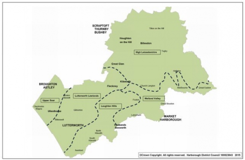
Fig. A.4 Landscape Character Areas
4.10 GD5 Supporting information
Table A.6 Supporting Information: Policy GD5
|
Does it meet national planning policy and guidance? |
Yes - NPPF paragraphs 17 (Core Principles), 109 and 156. Planning Practice Guidance Reference ID: 37-001-20140306. |
|
What evidence has informed this policy? |
Harborough District Landscape Character Assessment, 2007; Leicester PUA Landscape Character Assessment and Landscape Capacity Study, 2009 and Scraptoft Addendum, 2016; Market Harborough Landscape Character Assessment and Landscape Capacity Study, 2009; Lutterworth and Broughton Astley Landscape Character Assessment and Landscape Capacity Study, 2011; Rural Centres Landscape Character Assessment and Landscape Capacity Study, 2014; and Houghton on the Hill Landscape Character Assessment and Landscape Capacity Study, 2016. |
|
Which Local Plan objectives will it meet? |
6 - Natural environment 7 - Historic environment |
|
How will it be implemented? |
Through decisions on planning applications. |
|
How will it be monitored? |
Any planning permission granted contrary to the criteria in this policy will be identified in the annual Authority Monitoring Report and the reasons for it being granted explained. |
GD6 Areas of Separation
1. Areas of Separation, shown on the Policies Map, are designated between:
(14) a. Great Bowden and Market Harborough; and
(13) b. Bitteswell, Lutterworth and Magna Park.
(5) 2. Development in the Areas of Separation will be permitted where it would not compromise, either alone or in conjunction with other existing or proposed development, the effectiveness of the Area of Separation in protecting the identity and distinctiveness of these settlements.
(4) 4.11 GD6 Explanation
4.11.1 Areas of Separation are defined where the potential risk of merging is at its greatest, whether this is between settlements or settlements and nearby employment areas. The function of these areas is to ensure that development does not harmfully reduce the separation between settlements or between settlements and employment areas.
4.11.2 Most settlements in the District are physically separated from each other and there is little danger of new development resulting in villages or towns merging together. However, there are some settlements where potential coalescence with neighbouring settlements or employment areas is of concern. Some of these settlements have Conservation Area status, meaning that protecting individual settlement character from neighbouring development has added significance.
4.11.3 The prevention of coalescence has already seen the designation of Areas of Separation in 'made' neighbourhood plans. Policy EH2 of the Broughton Astley Neighbourhood Plan, 2014 prevents the merging of Sutton in the Elms and Broughton Astley. Policy S7 of the Scraptoft Neighbourhood Plan, 2015 defines an Area of Separation to ensure Scraptoft retains its identity and prevents coalescence with development to the south, including Thurnby and Bushby, although this is superseded by policy GD7 Green Wedges of this Local Plan which proposes a Green Wedge instead. A further Area of Separation is included in the Lubenham Neighbourhood Plan to retain separation between Lubenham and Market Harborough. Other Areas of Separation may be added by future neighbourhood plans.
4.11.4 Policy GD6 focuses on maintaining separation in two areas where there are specific development pressures and local community concerns over the potential loss of settlement identity. The Great Bowden/ Market Harborough Area of Separation seeks to retain the identity of Great Bowden and prevent coalescence with Market Harborough. The other Area of Separation is between Bitteswell/ Lutterworth/ Magna Park and this aims to protect the identity of Bitteswell from the growth of nearby Lutterworth, and to maintain separation of both Lutterworth and Bitteswell from Magna Park.
4.11.5 In order to provide robust evidence to the support the policy, the Council commissioned the Area of Separation Review, 2017. This study focused on the Market Harborough/ Great Bowden and Lutterworth/ Bitteswell/ Magna Park areas and categorised land into parcels that make a primary, supporting or incidental contribution to separation. This evidence was important to defining detailed Area of Separation boundaries.
4.11.6 Applicants putting forward proposals in these areas will need to show that they have considered the effect on the degree of separation and suggest mitigation measures to minimise the impact on separation.
4.12 GD6 Supporting information
Table A.7 Supporting Information: Policy GD6
|
Does it meet national planning policy and guidance? |
Yes - NPPF paragraph 157. |
|
What evidence has informed this policy? |
Area of Separation Review, 2017; and Appeal decisions. |
|
Which Local Plan objectives will it meet? |
6 - Natural environment 7 - Historic environment |
|
How will it be implemented? |
Through decisions on planning applications. |
|
How will it be monitored? |
Any planning permission granted contrary to criterion 2 of this policy will be identified in the annual Authority Monitoring Report and the reasons for it being granted explained. |
GD7 Green Wedges
(27) 1. The Leicester/Scraptoft/ Bushby Green Wedge and Thurnby/Leicester/Oadby Green Wedge are defined on the Policies Map with the aims of:
(6) a. preventing the merging of settlements;
(1) b. guiding development form;
(2) c. providing access from urban areas into green spaces/open countryside; and
(1) d. providing recreational opportunities.
(2) 2. Development within Green Wedges will be permitted where:
(4) a. it relates to agriculture, horticulture, forestry, nature reserves, allotments, burial grounds, outdoor leisure, sporting or recreation facilities including school playing fields, cycleways, footpaths or bridleways;
(2) b. it retains the open and undeveloped character of the Green Wedge;
(1) c. it retains or creates additional green networks between the countryside and open spaces within the urban areas and benefits biodiversity;
(1) d. it retains or enhances public access to the Green Wedge, especially for recreation; and
(1) e. any built development is small scale and necessary to the operational requirements of the activity.
4.13 GD7 Explanation
(2) 4.13.1 The fringes of Leicester present particular issues in terms of the use and environmental quality of land adjoining the built-up areas. Whilst Leicester does not have a green belt, Green Wedges have formed part of planning policy for the Leicester urban area for almost 30 years. Green Wedges are strategic areas of land, mostly extending from the City into adjacent local authority areas. They are areas of largely undeveloped open land between the urban area and the surrounding countryside. They differ from Areas of Separation in that they are aimed not just at preventing the merging of settlements but also guiding development form, providing a 'green lung' into urban areas and facilitating recreational opportunities.
4.13.2 Harborough's Green Wedges form part of the network of such designations around the Leicester urban area. The Leicester/Scraptoft/ Bushby Green Wedge lies entirely within Harborough District and the Thurnby/Leicester/Oadby Green Wedge adjoins similar designations in Leicester City and Oadby & Wigston Borough. Given that the importance of these areas extends beyond administrative boundaries, Green Wedges have been the focus of joint working for many years, including the preparation of an agreed joint methodology for the review of their boundaries in 2009, and are now a significant element of the Duty to Cooperate.
4.13.3 The National Planning Policy Framework (NPPF) states that access to high quality open spaces and opportunities for sport and recreation can make an important contribution to the health and well-being of communities (paragraph 73). It also makes clear that significant development should be focused in locations which are or can be made sustainable (paragraph 17). The Local Plan should therefore ensure that both aims are balanced and achieved. The purpose of Green Wedges is not to restrict the growth of an urban area but to ensure that, as urban development extends, open land is incorporated within it. The policy is more restrictive than countryside policies GD3 Development in the countryside and GD4 New housing in the countryside, which do not apply in Green Wedges.
4.13.4 The Core Strategy, 2011 supported the retention of Green Wedges and committed to a review of their boundaries as part of the Local Plan preparation process. The Green Wedge Review – Draft Technical Update, 2015 supported the Options Consultation in September/October 2015. Whilst it recommended that the boundaries remained largely unchanged from those identified in the 2001 Local Plan, it added that the boundaries put forward through the Local Plan would need to take into account the scale and distribution of housing required to meet need up to 2031. More recently the boundaries of the Leicester/Scraptoft Green Wedge were defined in the Scraptoft Neighbourhood Plan, 2016.
(6) 4.13.5 This Local Plan allocates Scraptoft North SDA for housing with accompanying infrastructure and community facilities. This results in a reduction in the size of the existing Green Wedge to the north of the village.
4.13.6 Policy GD7 defines an area of Green Wedge, comprising grazing paddocks between Scraptoft village and development within the City of Leicester, together with land to the south of Scraptoft village, incorporating the Edith Cole Memorial Park and the land on the upper slopes of the Thurnby Brook valley. The land was previously identified as part of the Green Wedge and part of the Area of Separation included in the Scraptoft Neighbourhood Plan, 2016.
4.13.7 The designation of the combined area as Green Wedge recognises that it has an important role to play in protecting Scraptoft village from merging with other built up areas to the south and west, thereby guiding future growth in Scraptoft, Thurnby and Bushby, allowing opportunities for access to the countryside and providing improvements to recreational opportunities. Not only does the designation ensure that Scraptoft village, in particular the Conservation Area, is protected from the adverse impacts of major development, but it also provides opportunities for the provision of recreational facilities as part of the new SDA. There is also substantial development committed to the south of Thurnby Brook in Thurnby and Bushby parish and the Green Wedge allows for strategic green space and access to the countryside to be incorporated as this growth takes place. The name of the Green Wedge has been changed to Leicester/ Scraptoft/ Bushby to reflect its wider coverage.
(4) 4.13.8 The Thurnby/Leicester/Oadby Green Wedge is a more extensive designation. The outer extent of the wedge south of Thurnby runs south of Bushby Lodge Farm to the edge of Stoughton Airfield. The village of Stoughton is completely surrounded by the designation which serves to protect it from coalescence with Leicester City and Oadby. The Green Wedge penetrates into Leicester City to encompass Evington Golf Course and the Arboretum. Whilst the boundaries of the Thurnby/Leicester/Oadby Green Wedge remain similar to those identified in the 2001 Harborough Local Plan, they have been drawn to exclude built development along Uppingham Road, including that associated with Coles Nursery, and along Stoughton Road.
4.13.9 The Green Wedges incorporate areas of land of differing agricultural and environmental quality, which may be suitable for different types of land uses. The only types of land use that will normally be considered appropriate for these areas are those where the predominantly open and undeveloped nature of the land is retained. It is recognised that built development may be required in connection with some of the uses identified in the policy.
4.14 GD7 Supporting information
Table A.8 Supporting Information: Policy GD7
|
Does it meet national planning policy and guidance? |
Yes - NPPF paragraphs 73 and 114. |
|
What evidence has informed this policy? |
Green Wedge Review, Technical Update 2015; Leicester PUA Landscape Character Assessment and Landscape Capacity Study, 2009; Leicester PUA Landscape Character Assessment and Landscape Capacity Study, Scraptoft Addendum, 2016; Site visits, aerial photography, and O.S. maps (showing public rights of way) |
|
Which Local Plan objectives will it meet? |
4 - Infrastructure 6 - Natural environment 7 - Historic environment 13 - Tourism and culture |
|
How will it be implemented? |
Through decisions on planning applications. |
|
How will it be monitored? |
Any planning permission granted contrary to the criteria in part 2 of this policy will be identified in the annual Authority Monitoring Report and the reasons for it being granted explained. |
GD8 Good design in development
(11) 1. Development will be permitted where it achieves a high standard of design, including meeting the following criteria:
(1) a. being inspired by, respecting and enhancing both the local character and distinctiveness of the settlement concerned;
b. where appropriate, being individual and innovative, yet sympathetic to the local vernacular, including in terms of building materials;
(1) c. in areas with high heritage value (Conservation Areas and in proximity to Listed Buildings, Scheduled Monuments and other heritage assets and their settings), reflecting those characteristics that make these places special;
(2) d. respecting the context and characteristics of the individual site, street scene and the wider local environment to ensure that it is integrated as far as possible into the existing built form;
e. being designed to minimise impact on the amenity of existing and future residents by:
(4) i. not having a significant adverse effect on the living conditions of existing and new residents through loss of privacy, overshadowing and overbearing impact, and
(2) ii. not generating a level of activity, noise, vibration, pollution or unpleasant odour emission, which cannot be mitigated to an appropriate standard and so would have an adverse impact on amenity and living conditions;
f. minimising the amount of water consumption;
(1) g. minimising pollution from glare or spillage of light from external lighting;
h. minimising opportunity for crime and maximising natural surveillance;
(1) i. protecting and enhancing existing landscape features, wildlife habitats and natural assets (including trees, hedges and watercourses) as an integral part of the development;
(1) j. enhancing the public realm, including high quality open spaces and links to the wider green infrastructure network to promote healthy lifestyles;
(1) k. making provision for the needs of specific groups in the community such as the elderly and those with disabilities;
(2) l. ensuring safe access, adequate parking and servicing areas including for refuse collection in new residential development;
m. ensuring the safe, efficient and convenient movement of all highway users, including bus passengers, cyclists, pedestrians and horse riders; and
n. where the site has previously been developed:
i. identifying the need for any decontamination and implementing this to an agreed programme; and
(1) ii. ensuring that any contamination is not relocated elsewhere to a location where it could adversely affect the water environment or other wildlife habitats.
(2) 4.15 GD8 Explanation
4.15.1 This policy requires all proposals to achieve a high standard of design quality to ensure that new development is both sustainable and attractive. It aims to safeguard and improve the character and distinctiveness of the District both now and for future generations. Well designed places relate well to their environment, are attractive and safe, and offer an improved quality of life for those that live and work in the District. Crime and community safety are important factors as part of all new development, and the Council works with Leicestershire Police and developers to ensure that all new major developments are secured by design.
4.15.2 Although set out as a separate design policy, these issues are important threads that run through all aspects of the Local Plan, including the policies for individual places, heritage, the countryside, climate change, green infrastructure and town centres. The Council would encourage applicants for full or reserved matters applications for all major residential schemes of 10 dwellings and above to submit assessments based on best practice design tools such as Building for Life 12 (Design Council) and 'Active Design' (Sport England, in conjunction with Public Health England) as updated to assist in complying with relevant criteria of Policy GD8.
4.15.3 The District is rich in both designated assets, such as Conservation Areas, Listed Buildings, Registered Parks and Gardens, and Scheduled Monuments, resulting in many settlements having their own unique identities and character. The Local Plan will support these characteristics with new development being sympathetic and appropriate to the character of each settlement.
4.15.4 Impact on neighbouring amenity resulting from new development is an important consideration in determining planning applications. An impact on amenity through poor design may impact on the quality of life of neighbouring occupiers, or result in a disconnected development that fails to relate to its context. Applications that result in unacceptable harm to neighbouring amenity, through an overlooking or overbearing impact, or resulting in noise, odour or light pollution or disturbance will be resisted unless the harm can be overcome through suitable planning conditions.
4.15.5 Supplementary Planning Guidance (SPG) (see Appendix B Supporting evidence) sets out, and new Supplementary Planning Documents will set out, guidance for new development including minimum distances between principal windows and guidance for appropriate design of new dwellings and extensions to dwellings.
4.15.6 Due to the special characteristics of settlements in the District, the Council encourages neighbourhood plans to develop appropriate design guides, through incorporation of Countryside Design Summaries, Village Design Statements or specific policies into the neighbourhood plans. These policies should be justified and provide additional and location-specific guidance to help inform future planning applications in the neighbourhood area. Such neighbourhood plan policies will be subject to viability considerations and compliance with all Local Plan policies, the National Planning Policy Framework and Planning Practice Guidance, and any other material considerations.
4.15.7 Land that is affected by contamination can pose a threat to groundwater, surface water, human health and the wider environment. Consideration of these risks at an early stage is an important consideration in the regeneration of brownfield land.
4.16 GD8 Supporting information
Table A.9 Supporting Information: Policy GD8
|
Does it meet national planning policy and guidance? |
Yes - NPPF paragraphs 56-68. |
|
What evidence has informed this policy? |
Harborough Supplementary Planning Guidance Notes; Building for Life 12 - 3rd edition, 2015; Active Design, Sport England, 2015. |
|
Which Local Plan objectives will it meet? |
3 - Location of development 6 - Natural environment 7 - Historic environment 9 - Design 12 - Environmental impact |
|
How will it be implemented? |
Through decisions on planning applications. |
|
How will it be monitored? |
Any planning permission granted contrary to the criteria in this policy will be identified in the annual Authority Monitoring Report and the reasons for it being granted explained. |
(2) GD9 Minerals Safeguarding Areas
(1) 4.17 GD9 Explanation
4.17.1 In relation to minerals the National Planning Policy Framework (NPPF) places requirements on both local planning authorities and mineral planning authorities. The NPPF identifies that great weight should be given to the benefits of mineral extraction and local planning authorities should identify Minerals Safeguarding Areas. Leicestershire is a two-tier area for local government and Leicestershire County Council is the minerals planning authority. The County Council will be identifying Minerals Safeguarding Areas and supporting policies as part of the emerging Minerals Local Plan.
4.17.2 The County Council will be consulted on non-exempt development proposals in Minerals Safeguarding Areas. Non-exempt development proposals are those which would lead to the unnecessary sterilisation of mineral resources within a Minerals Safeguarding Area.
4.17.3 In the draft Minerals Local Plan (summer 2015), extensions were proposed to the existing Shawell Quarry, and a new quarry proposed at Pincet Lane, North Kilworth. In addition, the pre-submission plan (summer 2016) proposes an extension to an existing quarry at Husbands Bosworth.
4.17.4 Policy GD9 sets out the approach that the District Council will take when determining proposals for non-minerals development within Minerals Safeguarding Areas. The Minerals Local Plan will identify Minerals Safeguarding Areas within Harborough District to which the policy will apply. Proposals for non-mineral development in these areas need to demonstrate that mineral resources will not be unnecessarily sterilised. Where this cannot be demonstrated, or where the need for the non-mineral development is clear and demonstrable, the County Council would require that the practicality of prior extraction be fully investigated.
4.18 GD9 Supporting information
Table A.10 Supporting Information: Policy GD9
|
Does it meet national planning policy and guidance? |
Yes - NPPF paragraphs 142-149. |
|
What evidence has informed this policy? |
Leicestershire County Council Minerals and Waste Local Plan Draft, 2015. Leicestershire County Council Minerals and Waste Local Plan Pre-submission, 2016. |
|
Which Local Plan objectives will it meet? |
3 - Location of development 6 - Natural resources 12 - Environmental impact |
|
How will it be implemented? |
Through decisions on planning applications. |
|
How will it be monitored? |
Any planning permission granted contrary to the criteria in this policy will be identified in the annual Authority's Monitoring Report and the reasons for it being granted explained. |