Harborough Local Plan 2011-2031, Proposed Submission
Part D Appendices
Appendix A Relationship with adopted Core Strategy, 2011 and Local Plan, 2001 'Saved Policies'
Table D.1 Relationship with the adopted Core Strategy, 2011 and Local Plan, 2001 'Saved Policies'
|
Saved Policy |
Policy Name / Description |
Superseded by Local Plan 2011-31 Policy reference |
|
Harborough District Core Strategy 2006-2028 (adopted 2011) |
||
|
CS1 |
Spatial Strategy |
SS1: The spatial strategy |
|
CS2 |
Delivering New Housing |
SS1: The spatial strategy; H1: Provision of new housing; GD2: Settlement development; GD4: New housing in the countryside; H5: Housing density, mix and standards |
|
CS3 |
Delivering Housing Choice and Affordability |
H2: Affordable housing; H3: Rural exception sites; H4: Specialist housing; H5: Housing density, mix and standards |
|
CS4 |
Providing for Gypsy, Traveller and Travelling Showpeople Needs |
H6: Gypsy, Traveller and Travelling Showpeople accommodation |
|
CS5 |
Providing Sustainable Transport |
IN2: Sustainable transport; |
|
CS6 |
Improving Town Centres and Retailing |
RT1: Provision of new retail uses; RT2: Town and local centres; RT3: Shop fronts and advertisements; RT4: Tourism and leisure |
|
CS7 |
Enabling Employment and Business Development |
BE1: Provision of new business development; BE2: Strategic distribution; BE3: Existing employment areas; GD3: Development in the countryside |
|
CS8 |
Protecting and Enhancing Green Infrastructure |
GI1: Green infrastructure networks; GI2: Open space, sport and recreation; GI4: Local Green Space, GI5: Biodiversity and geodiversity; GD7: Green Wedges |
|
CS9 |
Addressing Climate Change |
CC1: Mitigating climate change; CC2: Renewable energy generation; CC4: Sustainable drainage |
|
CS10 |
Addressing Flood Risk |
CC3: Managing flood risk; CC4: Sustainable drainage |
|
CS11 |
Promoting Design and Built Heritage |
GD8: Good design in development; HC1: Built heritage |
|
CS12 |
Delivering Development and Supporting Infrastructure |
IN1: Infrastructure provision; IN2: Sustainable transport; IN3: Electronic connectivity; IN4: Water resources and services; CC1: Mitigating climate change; CC2: Renewable energy generation; CC3: Managing flood risk; CC4: Sustainable drainage; GI1: Green infrastructure networks; GI2: Open space, sport and recreation; GI3: Cemeteries |
|
CS13 |
Market Harborough |
SS1: The spatial strategy; H1: Provision of new housing; GD6: Areas of Separation; MH1: Overstone Park; MH2: East of Blackberry Grange; MH3: Burnmill Farm; MH4: Land at Airfield Farm; MH5: Airfield Business Park; MH6: Compass Point Business Park; RT1: Provision of new retail uses; RT2: Town and local centres; RT4: Tourism and leisure |
|
CS14 |
Lutterworth |
SS1: The spatial strategy; L1: East of Lutterworth Strategic Development Area; L2: Land south of Lutterworth Road/ Coventry Road; H1: Provision of new housing; RT1: Provision of new retail uses; RT2: Town and local centres; GD6: Areas of Separation |
|
CS15 |
Leicester Principal Urban Area |
SS1: The spatial strategy; H1: Provision of new housing; SC1: Scraptoft North Strategic Development Area; GD7: Green Wedges |
|
CS16 |
Broughton Astley |
SS1: The spatial strategy; H1: Provision of new housing |
|
CS17 |
Countryside, Rural Centres and Rural Villages |
SS1: The spatial strategy; H1: Provision of new housing; H3: Rural exception sites; GD3:Development in the countryside; GD4: New housing in the countryside; BE1: Provision of new business development; RT2: Town and local centres; HC1: Built heritage; HC2: Community facilities; HC3: Public houses, post offices and village shops; F1: Land off Arnesby Road; F2: Land off Marlborough Drive; K1: Land south and west of Priory Business Park |
|
Retained Saved Policies of the Harborough District Local Plan (2001) |
||
|
RM/8 |
Sites of Local Ecological or Geological Interest |
GI5: Biodiversity and geodiversity |
|
EV/2 |
Green Wedges |
GD7: Green Wedges |
|
EV/3 |
Separation of Settlements |
GD6: Areas of separation |
|
HS/8 |
Limits to Development |
GD2: Settlement development; GD3: Development in the countryside; GD4: New housing in the countryside |
|
HS/9 |
Important Open Land |
GD2: Settlement development; GD5: Landscape and townscape character; GI4: Local Green Space |
|
EM/2 |
Control of Development on Employment Sites |
BE3: Existing employment areas |
|
EM/9 |
Stoughton Airfield-general |
BE5: Leicester Airport, Stoughton |
|
EM/10 |
Stoughton Airfield -criteria for development |
BE5: Leicester Airport, Stoughton |
|
EM/11 |
Airfield Farm |
H1: Provision of new housing; BE1: Provision of new business development; MH4: Land at Airfield Farm; MH5: Airfield Business Park |
|
EM16 - 23 |
Bruntingthorpe Proving Ground and Airfield |
BE4: Bruntingthorpe Proving Ground |
|
TR/1 |
Road improvement lines |
Deleted |
|
LR/14 |
Tourism - self catering accommodation |
RT4: Tourism and leisure |
|
LR/18 |
Foxton Locks Area-moorings |
Deleted |
|
SH/1 |
Principal Shopping and Business Areas |
RT2: Town and local centres |
|
Market Harborough policies |
||
|
MH/1 |
Land between Burnmill Road and Leicester Road |
Deleted |
|
MH/2 |
Land north of Kettering Road |
Deleted |
|
MH/3 |
Land west of Farndon Road |
Deleted |
|
MH/4 |
Land west of Northampton Road |
BE1: Provision of new business development |
|
MH/5 |
Land east of Northampton Road |
BE1: Provision of new business development; MH2: East of Blackberry Grange; MH6: Compass Point Business Park |
|
MH/6 |
Land east of Rockingham Road |
BE1: Provision of new business development; BE3: Existing employment areas |
|
MH/7 |
Former railway goods yard |
BE1: Provision of new business development |
|
MH/8 |
Kettering Road/ Rockingham Road-employment area |
BE1: Provision of new business development; H1: Provision of new housing |
|
MH/10 |
Development in Principal Shopping and Business Area |
RT2: Town and local centres |
|
MH/11 |
Office development in Principal Shopping and Business Area |
RT2: Town and local centres |
|
MH/12 |
Redevelopment of the yards rear of High Street |
RT1: Provision of new retail uses; RT2: Town and local centres |
|
MH/13 |
Redevelopment of land at Mill Hill Road |
Deleted |
|
MH/14 |
Northampton Road Office Policy Area |
RT2: Town and local centres |
|
MH/15 |
St Mary's Road Mixed Use Policy Area |
RT2: Town and local centres |
|
Lutterworth policies |
||
|
LW/1 |
Retention of the former railway embankment |
H1: Provision of new housing; BE1: Provision of new business development; GD8: Good design in development |
|
LW/3 |
Land Between Bitteswell Road and Leicester Road |
Deleted |
|
LW/4 |
Land between Brookfield Way and Coventry Road |
Deleted |
|
LW/5 |
Land south of Coventry Road |
BE1: Provision of new business development; GI3: Cemeteries |
|
LW/6 |
Land east of Rugby Road |
BE3: Existing employment areas |
|
LW/7 |
Public recreation area land south of Orange Hill |
H1: Provision of new housing; BE1: Provision of new business development; GD8: Good design in development |
|
LW/8 |
Cemetery |
GI3: Cemeteries |
|
LW/9 |
Development in the Principal Shopping and Business Area |
RT1: Provision of new retail uses; RT2: Town and local centres |
|
LW/10 |
Office development in the Principal Shopping and Business Area |
RT1: Provision of new retail uses; RT2: Town and local centres |
|
LW/11 |
Extension of the George Street car park |
Deleted |
|
The Kibworths policies |
||
|
KB/1 |
Land off Wistow Road and Warwick Road |
Deleted |
|
KB/2 |
Land south of Harborough Road |
BE1: Provision of new business development, BE3: Existing employment areas |
|
Great Glen policies |
||
|
GG/1 |
Stretton Hall |
Deleted |
|
GG/2 |
Land east of Stretton Road |
Deleted |
|
Fleckney policies |
||
|
FL/1 |
Land south-west of Saddington Road |
Deleted |
|
Broughton Astley Policies |
||
|
BA/1 |
Land east of Cromford Way and Chandler Way |
Deleted |
|
Billesdon, Gilmorton, Stoughton, Tilton on the Hill and Ullesthorpe policies |
||
|
BI/1 |
Land south west of Rolleston Road |
Deleted |
|
SN/1 |
Land at Charity Farm, Gaulby Lane |
Deleted |
|
UL/1 |
Land east of Mill Road |
Deleted |
Appendix B Supporting evidence
The following documents have contributed to determining the policies of the Harborough District Local Plan and are listed on the council's website http://www.harborough.gov.uk/directory/4/our_policies_plans_and_strategies/category/29.
Documents are categorised and listed in alphabetical order unless otherwise stated. Some documents may be listed in more than one category.
Table D.2 Supporting evidence: Business and employment
|
Business and Employment |
|
Harborough Strategic Employment Land Availability Assessment Update (SELAA), 2017 |
|
HDC Existing Employment Area Review (EEAR), 2012 |
|
Leicester and Leicestershire Housing and Economic Development Needs Assessment (HEDNA), 2017 |
|
The Leicester and Leicestershire City Deal, March 2014 |
|
The Leicester and Leicestershire Growth Deal, 2014 |
|
Leicester and Leicestershire Strategic Distribution Sector Study (L&L SDSS), 2014 |
|
Leicester and Leicestershire Strategic Distribution Study: Update and Refresh of Outputs and Conclusions, (L&L SDSS Update), 2016 |
|
Leicester and Leicestershire Strategic Economic Plan (SEP) (2014-2020), 2015 |
|
LLEP Logistics & Distribution Sector Growth Plan, June 2015 |
|
Magna Park Employment Growth Sensitivity Study, 2017 |
|
Midlands Engine for Growth, 2017 |
|
Noise Management Plan relating to Bruntingthorpe Aerodrome and Proving Ground, 2009 |
|
Responses to the consultation on Local Plan Options, April 2016 |
|
Unilateral Undertaking relating to Bruntingthorpe Aerodrome and Proving Ground, 2009 |
Table D.3 Supporting evidence: Environment
|
Environment |
|
Anglian River Basin Management Plan, 2015 update |
|
Environment Agency: Drinking Water Protected Areas Safeguard Zones |
|
Environment Agency: Groundwater Source Protection Zones |
|
Harborough Climate Change Action Plan, 2015 |
|
Harborough Watercycle Study, 2015 |
|
Harborough Infrastructure Delivery Plan, 2017 |
|
Harborough Strategic Flood Risk Study, 2009 |
|
Humber River Basin Management Plan, 2016 update |
|
Landscape Sensitivity to Renewable Energy in Harborough District, 2016 |
|
The Leicestershire and Rutland Planning for Climate Change study, May 2008 |
|
Leicestershire County Council Minerals and Waste Local Plan Draft, 2015 |
|
Leicestershire County Council Minerals and Waste Local Plan Pre-submission, 2016 |
|
Leicestershire Flood Risk Management Strategy, 2015 |
|
Leicestershire Green Infrastructure Strategy: Volume 1 Phase 1 Habitat Study, 2008 |
|
Misterton Marshes SSSI, PBA/FPCR, 2016 |
|
Severn River Basin Management Plan, March 2016 update |
|
Space for Wildlife: Leicester, Leicestershire and Rutland Biodiversity Action Plan (2016–2026) 2nd edition, December 2016 |
|
Strategic Growth Plan Strategic Flood Risk Assessment - Harborough District Update, 2017 |
|
Water Cycle Study Addendum – Option 4 revised – Scraptoft North SDA, September 2016 |
|
Water Resources Management Plan 2014 Severn Trent |
|
Water Stressed Areas - final classification 2013 DEFRA |
Table D.4 Supporting evidence: Green infrastructure and open space
|
Green infrastructure and open space |
|
6Cs Sub-Regional Strategic Framework, 2010 |
|
Assessment of potential Local Green Space sites, 2014 |
|
Harborough Cemetery and Burial Strategy, 2016 |
|
Harborough Open Space Assessment, 2004 |
|
Harborough Open Spaces Strategy (2016 to 2021), 2016 |
|
Harborough District Playing Pitch Strategy, 2017 (This study is expected to be finalised in late 2017) |
Table D.5 Supporting evidence: Heritage and community facilities
|
Heritage and community assets |
|
The Canal and River Trust Destination Management Plan, 2016 |
|
Community Infrastructure Assessment, 2017 |
|
Community and landowner consultation, 2012 and 2013 |
|
Conservation Area Statements |
|
'Easy Access to Historic Buildings', Historic England, 2015 |
|
Enabling Development and the Conservation of Significant Places, Historic England, 2008 |
|
Harborough Cemetery and Burial Strategy, 2016 |
|
Harborough District Services audit, 2016 |
|
Harborough District Community Buildings, June 2016 |
|
Harborough District Pubs and Community rooms, June 2016 |
|
Harborough District Pubs, June 2016 |
|
Harborough District Village Halls, June 2016 |
|
Infrastructure Delivery Plan, 2017 |
Table D.6 Supporting evidence: Housing
|
Housing |
|
5 Year Housing Land Supply report (as at 31 March 2017), July 2017 |
|
Duty to Cooperate Statement |
|
Gypsy and Traveller and Travelling Showpeople Site Identification Study, July 2017 |
|
Harborough Self-Build Register |
|
Harborough Strategic Housing Land Availability Assessment (SHLAA), May 2016 |
|
Windfall Analysis, September 2016 |
|
The Leicester and Leicestershire Gypsy and Traveller Accommodation Assessment, May 2017 |
|
Leicester and Leicestershire Housing and Economic Development Needs Assessment (HEDNA), 2017 |
|
Leicester and Leicestershire Strategic Growth Statement, August 2016 |
|
Local Plan Viability Assessment, 2017 |
|
Magna Park Employment Growth Sensitivity Study, 2017 |
|
Memorandum of Understanding Statement (MoU), 2017 |
Table D.7 Supporting evidence: Monitoring and implementation
|
Implementation and monitoring |
|
5 Year Housing Land Supply report (as at 31 March 2017), July 2017 |
|
Annual Authority Monitoring Reports (AMRs) |
|
Harborough Self-Build Register |
|
Harborough Supplementary Planning Guidance Notes |
|
'Made' Neighbourhood Plans within the Harborough District |
Table D.8 Supporting evidence: Infrastructure
|
Infrastructure |
|
East Lutterworth SDA Junctions Cost Estimate, 2017 |
|
Local Plan Viability Assessment, 2017 |
|
Harborough Infrastructure Delivery Plan, 2017 |
Table D.9 Supporting evidence: Landscape
|
Landscape |
|
Area of Separation Review, 2017 |
|
Harborough District Landscape Character Assessment, 2007 |
|
Houghton on the Hill Landscape Character Assessment and Landscape Capacity Study, 2016 |
|
Green Wedge Review, Technical Update 2015 |
|
Landscape Sensitivity to Renewable Energy in Harborough District, 2016 |
|
Leicester PUA Landscape Character Assessment and Landscape Capacity Study, 2009 |
|
Leicester PUA Landscape Character Assessment and Landscape Capacity Study and Scraptoft Addendum, 2016 |
|
Lutterworth and Broughton Astley Landscape Character Assessment and Landscape Capacity Study, 2011 |
|
Market Harborough Landscape Character Assessment and Landscape Capacity Study, 2009 |
|
Preliminary Landscape Assessment of Alternative Strategic Development Areas, September 2016 |
|
Rural Centres Landscape Character Assessment and Landscape Capacity Study, 2014 |
Table D.10 Supporting evidence: Local plan preparation
|
Local Plan preparation - in date order |
|
Harborough Local Plan Scoping Consultation Report and Responses, 2013 |
|
Harborough Local Plan - Options Consultation, 2015 |
|
Responses to Options Consultation Paper, April 2016 |
|
Harborough District Statement of Community Involvement, 2015 |
|
Report to Local Plan Executive Advisory Panel, July 2016: Options Assessment and Selection (& supporting papers) |
|
Report to Local Plan Executive Advisory Panel Sept & Oct 2016: Assessment of Selected Spatial Options (& supporting papers) |
|
Site Appraisal Methodology, 2016 |
|
Harborough District Council's Local Development Scheme (LDS), July 2017 |
|
Local Plan Viability Assessment, 2017 |
|
Harborough Local Plan Proposed Submission - Sustainability Appraisal, 2017 |
|
Harborough Local Plan Proposed Submission - Habitat Regulations Assessment (HRA) Screening Opinion, 2017 |
Table D.11 Supporting evidence: People and places
|
People and places |
|
Data from the 2011 Census |
|
Nomis working population data, 2011 Census |
|
Public Health Profile for Harborough District, 2016 |
|
Spatial Portrait of Harborough District - included as Appendix D, 2016 |
|
Settlement profiles, 2015 |
Table D.12 Supporting evidence: Retailing
|
Retailing |
|
Harborough Retail Study, 2013 |
|
Harborough Retail Study Update, 2016 |
|
Harborough Retail Study Update, 2017 |
Table D.13 Supporting evidence: Tourism
|
Tourism |
|
The Canal and River Trust Destination Management Plan, 2016 |
|
East Leicestershire Tourism Accommodation Study, 2015 |
|
Harborough Blueprint for Tourism 2013-2018, 2013 |
|
LLEP Strategic Economic Plan, 2015 |
|
The Tourism Strategy for Leicester and Leicestershire (2011-2016), 2011 |
Table D.14 Supporting evidence: Transport
|
Transport |
|
A5 Sustainable Transport Strategy 2011-2026 |
|
Harborough District Local Plan Preliminary Traffic Impact Assessment, Nov 2016 |
|
Harborough District Potential Development Options Strategic Transport Assessment , 2015 |
|
Land East of Hamilton Lane Scraptoft Initial Transport Feasibility Assessment, 2016 |
|
Leicestershire County Council 6Cs Design Guide, 2013 |
|
Leicestershire County Council Local Transport Plan 3 |
|
Leicestershire County Council Local Transport Plan 3 Implementation Plan (2015/2016) |
|
Leicestershire County Council Market Harborough Rural Cycle Map, 2013 |
|
Leicester and Leicestershire Draft Rail Strategy, 2016 |
|
Lutterworth East SDA Junctions Operational Assessment, 2016 |
|
Lutterworth East Strategic Transport Assessment 2017 Update, 2017 |
|
Lutterworth East Strategic Transport Assessment, 2016 |
|
Market Harborough Transport Strategy (2017-2031), 2016 |
|
The Midlands Connect Emerging Strategy, November 2016 |
|
The Midlands Connect Strategy, March 2017 |
|
Scraptoft, Leicestershire Transport Scoping Report, 2017 |
|
South East Leicester Transport Study, 2016 |
Appendix C References
Leglisation, guidance and national information sources referenced in the Local Plan are outlined in the in table below. Other evidence documents are set out in Appendix B, supporting evidence. All the web addresses were correct at the date of publication.
Table D.15 Table of References
Appendix D Spatial portrait
Location
Harborough District is a largely rural area situated in the East Midlands region and lies within the Leicester and Leicestershire Housing Market Area (HMA). It covers an area of 238 square miles of rural south and east Leicestershire. The District borders Warwickshire (and the West Midlands) to the west, Northamptonshire to the south and Rutland to the east. Harborough also adjoins five other Leicestershire planning authorities, namely Charnwood, Melton, Oadby and Wigston, Blaby, and Leicester City.
Fig. A.1 in Chapter 1 provides some geographical context of Harborough District's location within the Leicester and Leicestershire Housing Market Area.
Population
Harborough District has a growing population, increasing by 11.5 % between 2001 and 2011 to 85,382. This is slightly above the total Leicester and Leicestershire Housing Market Area (HMA) resident population increase, which rose by 10.2% to 980,328 over the same period. Harborough District experienced the second highest percentage increase in resident population across the HMA. Please see Fig. D.1 below.
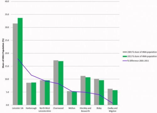
Fig.
D.1 Leicester, Leicestershire
and Rutland HMA Residential Population
Variation between Census 2001 and Census 2011 data
The District's population is most concentrated in the larger settlements of:
- Market Harborough, Lutterworth and Broughton Astley (47%);
- Billesdon, Great Glen, Houghton on the Hill, Husbands Bosworth, The Kibworths, Fleckney and Ullesthorpe (22%); and
- Scraptoft, Thurnby and Bushby (6%)
The remaining 25% of residents are dispersed across approximately 80 smaller rural villages, as shown in Fig. D.2.
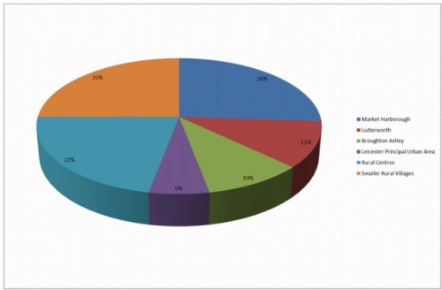
Fig.
D.2 Population Distribution by
Settlement
(%)
The 2011 Census highlights small but significant changes to the population structure in the District since 2001:
- the population of school age children and students increased by almost 11%;
- strong evidence of an ageing population with 17.8% of the population aged 65 and over compared to 15.7% in England with some rural settlements having even higher populations of older people; and
- the mean age of the District's population increased from 40 in 2001 to 42 in 2011.
The 2014 sub-national population projections from the Office for National Statistics (ONS) estimate a population of 88,008 in 2014 and forecast an increase to 99,814 in 2031, which equates to an 8.2% increase. The bulk of this increase is expected to come from in-migration to the District from within the UK. There is also expected to be an increase in the number of people aged 65 and over, with an increase to almost a quarter (24.3%) of the population of the District being within this group by 2024.
The District has a very low ethnic mix, with 92.8% of the population giving white-British as their ethnic group in the 2011 Census. The next largest group is identified as Asian/British Asian (Indian) at 2.2%. The Census data indicates that 62.5% consider themselves to be Christian. The next highest category is no religion at 24.6%.
Over 50% of the District's 16 and over population are married and just over a quarter are single (never been married or never registered a civil partnership).
Households
The 2011 Census identified 34,898 households in the District. This is an increase of 18% since 2001.
Household tenure statistics for the District captured by the 2011 Census reveal a number of key changes when compared with the 2001 Census:
- 'Social rented other' increased significantly from 522 to 2,442 households (following transfer of Council stock to Seven Locks Housing Association in December 2007);
- 'Owned: with mortgage or loan' dropped by 8% to 13,849;
- 'Private rented: private landlord or letting agency' increased by 132% from 1,524 in 2001 to 3,540 in 2011; and
- 'Shared ownership' tenures almost doubled from 226 in 2001 to 414 in 2011.
However, there has also been a 25% increase in property that is owned outright, demonstrating some resilience to the challenging economic climate and the above average proportion of residents aged 65 and over in the District.
Accommodation types across the District reflect the area's rural and low density characteristics and the relative affluence of residents compared with UK averages, please see Fig. D.3 below:
- 48% occupy detached houses, compared with 23% nationally;
- 7% occupy purpose-built flats, compared with 16% nationally; and
- 15% occupy terraced houses, compared with 25% nationally.
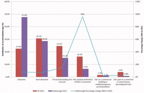
Fig. D.3 Harborough Accommodation Types compared to UK Average
Families with dependent children make up 23.7% of households, significantly higher than the England average of 19.3%. Households of one or more adults all aged 65 and over are also more common with 23.3% of households falling into this category, compared to the England average of 20.5%. There is, however, a lower percentage of single person, under 65, households in the District (13.3%) compared to the England average (17.9%). There are 29% of households with no adults in work including unemployed and retired households.
Services and facilities
Market Harborough and the key centres of Lutterworth and Broughton Astley provide the most services and facilities for the District.
Market Harborough has a wide range of services that make the town attractive for residents and visitors. The services available in Market Harborough support its continued status as the principal town within the District and its designation as a sub-regional centre.
Basic services include primary schools, GP surgeries, library, public houses, food shops and post offices. Other services set Market Harborough apart as the biggest provider in the District. These include two secondary schools, one of which offers A-levels, Brooke House independent school and college, several dentists and a wide range of other medical services including physiotherapists and osteopaths. The town centre benefits from a large market hall, refurbished library and museum, a theatre, and a wide retail offer including national chain stores and a large number of independent retailers, for which the town is well known locally. In addition, there is a leisure centre with pool, a range of sports facilities, a variety of parks, a cemetery, various churches and day nurseries/pre-schools.
Lutterworth is a smaller town than Market Harborough, with less than half the population, but it benefits from a good range of services, although on smaller scale than Market Harborough. These include secondary schools, a leisure centre, which includes a swimming pool, and a good range of shops. Lutterworth's extensive range of services and facilities supports its continued designation as a key centre.
Broughton Astley is a large village with all key services and many other amenities, including a secondary school, which lead to it being designated a key centre. However, it is recognised as not enjoying the range of shops and services expected for the size of its population. The Broughton Astley Neighbourhood Development Plan (made 2014) aims to improve services and facilities for the community. In 2014 the Council granted outline planning permission for a mixed use development comprising:
- up to 310 residential units;
- a food store and petrol station;
- a community leisure and sports building;
- a medical centre;
- employment units; and
- a variety of areas for formal and informal sport and recreation.
ThePrincipal Urban Area (PUA) is a term used to describe the continuous built up area of Leicester, including the Leicester City Council area and adjoining settlements in neighbouring districts. In Harborough District it consists of the settlements of Thurnby, Bushby and Scraptoft that are within easy reach of Leicester's services and facilities.
Rural centres across the District (The Kibworths, Fleckney, Great Glen, Billesdon, Ullesthorpe, Husbands Bosworth and Houghton on the Hill) all have at least four of the six key services (general practitioner, library, public house, primary school, food shop, post office).
Selected rural villages are served by a minimum of two of the six key services. They are Bitteswell, Church and East Langton, the Claybrookes, Dunton Bassett, Foxton, Gilmorton, Great Bowden, Great Easton (with Bringhurst), Hallaton, Lubenham, Medbourne, North Kilworth, South Kilworth, Swinford, Tilton on the Hill and Tugby. With the exception of Medbourne and Tilton on the Hill, these villages all have a primary school.
Health
The health of Harborough residents is generally good. The
life expectancy for men is 80.8 years and 84.5 years for
females, this is higher than the England average of 79.5 and
83.2 respectively. Many of the indicators of health measured
by Public Health England show Harborough performing better
than the England average.
According to the 2011 Census, a total of 8,983 (10.5%) of Harborough residents provided unpaid care, which is in line with the national average. Of these, 2,420 (2.8%) provide 20 or more hours of unpaid care per week. This is slightly below the national average of 3.7%.
The District has no major hospitals, but has a number of smaller cottage hospitals offering outreach services from the main hospitals in Leicester. In 2017 the old cottage hospital in Market Harborough closed and was replaced by a new, purpose built facility to the north of the town. The new hospital is on the site of the previous St Luke's hospital and provides an integrated health hub including primary care, general practice, outpatient and diagnostic facilities. Lutterworth has the Fielding Palmer hospital. These hospitals offer clinics and some forms of palliative care. Residents use larger hospitals in Leicester, Kettering, Rugby and Coventry for A&E and more serious illnesses.
There are GP surgeries in Market Harborough, Lutterworth, Broughton Astley, Bushby, Billesdon, Fleckney, Great Glen, Husbands Bosworth, The Kibworths and Ullesthorpe.
Built environment
Harborough District is made up of a variety of settlements. The vernacular style varies across the District, with stone houses in many villages close to the Northamptonshire boundary, but red brick in other parts of the District. Many of the villages have Conservation Areas defined around their historic core. There are 62 Conservation Areas in total.
The District has a rich and varied heritage with 1,250 listed buildings, 60 scheduled monuments and 6 registered parks and gardens. There are important sites related to the civil war in the area around Market Harborough. The District also enjoys a varied industrial heritage, with links to corsetry and food, as well as the Grand Union Canal. In addition Lutterworth has close links to Sir Frank Whittle, the designer of the jet engine, who worked in Lutterworth during the 1930s and 1940s. Market Harborough and Lutterworth are important market towns with each having an historic core and character.
Transport and communications
The District's central location provides access to regional and national transport links.
Road connections: The motorway network is accessible via the M1 which passes through the west of the District , while the M6/A14 junction is located in the south west of the District . Other main routes in the District include the A6, A5, A47, A426, A5199, A4304, and A508 which between them provide links to Leicester, Northampton, Kettering, Corby, Rugby and Peterborough.
Car ownership: 88% of the District's households have access to at least one car. Travelling by car is the predominant method of getting to work for Harborough residents.
Rail connections: Market Harborough is located on theEast Midlands Trains rail route, with frequent links to London, Leicester and other stations north and south. It also provides connections at St.Pancras International for forward services to continental Europe via Eurostar, the north Kent coast and the south coast via the Thameslink service. Between 2017 and 2019 the station and railway line through it will be subject to major upgrading.
Airports: East Midlands Airport and Birmingham Airport are within 50 miles of much of the District. There is a rail link to Luton Airport from Market Harborough, which is about 60 miles away.
Bus services: There are bus services connecting various villages to larger settlements that are provided by Hinckley Bus, Arriva and Demand Responsive Transport (DRT). For more details of bus services throughout Harborough District please see the website www.choosehowyoumove.co.uk at the following link www.choosehowyoumove.co.uk. Public transport provision in rural parts of the District is limited, with a number of the smaller villages and hamlets having no bus service.
Access to reliable super-fast broadband: Most rural areas still receive below the Government target of 25mbps (megabytes per second). Several settlements throughout the District have benefited from the implementation of 'Superfast Leicestershire' and other locally-driven projects. These projects aim to bring superfast fibre broadband (above 24 mbps) to as many premises in Leicestershire as possible. See the link www.superfastleicestershire.org.uk for updated information.
Employment and economic activity
Estimates from Nomis (official labour market statistics) for 2015 indicate that there were around 89,300 residents in Harborough District of which some 54,200 are of working age (16 – 64 years). Of those that are of working age:
- 47,400 residents aged 16 - 64 years are economically active (in work or looking for work);
- 45,800 residents aged 16 - 64 years are in work;
- 1,100 are unemployed individuals aged 16 – 64 years; and
- 3,400 residents of working age are retired.
The District consistently has low levels of unemployment and over 50% of the working residents are employed in professional occupations as managers, professionals and associate professionals.
- 11.7% of the workforce are process plant and machine operatives or in 'elementary occupations';
- 11.1% are working as 'managers, directors and senior officials';
- 10.7% are 'skilled trade persons';
- 22.6% are in 'professional occupations'; and
- 17.4% are in 'associate professional and technical occupations'.
The number of people with qualifications is generally higher than the UK average for all levels of qualification. However, these statistics mask the variation between residents who work outside of the District and those who work within the District. The most prevalent occupation amongst Harborough's workplace population is 'elementary occupations', at 20%. Please see Fig. D.4 below.
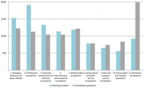
Fig.
D.4 Employment
Variation between employment of those resident in the
district and those whose workplace is in the district
The difference between the resident and workplace skill base is also clearly illustrated when income levels between the two groups are compared. The resident population earns above the national average weekly income, whilst the District's workplace population earns below the national average weekly income. Please see Table D.16 below.
Table D.16 Census 2011 Gross Weekly Earnings
|
Gross weekly earnings |
Harborough residents |
Harborough workplace |
Great Britain Average |
|
Full-time workers |
£552.50 |
£498.00 |
£520.80 |
Compared with the national average, the District has higher levels of employment in the following key sectors:
- agriculture/forestry/fishing and textile manufacturing;
- wholesale and retail trade;
- vehicle sale and repair;
- transport and storage;
- mining and quarrying;
- chemical manufacturing; and
- administrative and support services.
Census data indicates that industries under-represented, compared with national averages, are:
- financial and insurance activities;
- information and communication;
- electricity and gas;
- steam and air conditioning supply; and
- arts, entertainment and recreation activities.
The average distance travelled to work by Harborough residents is 17.5km, compared with a national average of 14.5km. Almost two thirds of the Harborough workforce travels to work by car or van and use of public transport is low at 3%. Working from home accounts for 8% of the workforce (compared to 5% nationally), this is a marked increase since 2001 and the roll-out of high speed broadband to rural localities, which is currently under way, may lead to a further increase in home-based working over coming years. The majority of workers travel to Leicester, however, the west of the District sees inflows of workers commuting from Hinckley and Bosworth and Nuneaton. Please see Fig. D.5 below.
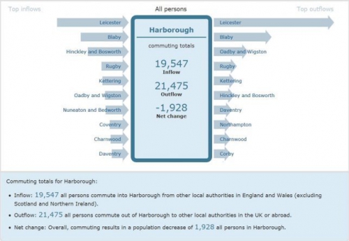
Fig.
D.5 Commuting into and out of
Harborough District
Source: ONS, Census WU01EW - Location of usual residence and
place of work by sex (Mid Layer Super Output Area level)
Landscape and natural environment
Harborough District is predominately a rural area and will remain so. While there are no national landscape designations, the District is made up of five broad landscape character areas as defined by the Harborough District Landscape Character Assessment 2007. These are listed below (see also Fig. D.6 below):
- Laughton Hills with its distinct ridge line of rolling hills and steep slopes;
- Lutterworth Lowlands characterised by an open and relatively flat to gently rolling landscape;
- Welland Valley which follows the gently meandering course of the river and its wide, flat valley;
- High Leicestershire with its distinctive steep valleys, broad ridges, woodland areas and network of small villages; and
- Upper Soar with its wide, open landscape with lack of substantial woodland.
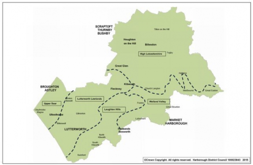
Fig. D.6 Landscape Character Areas
The Rivers Welland and Avon form much of the District's southern boundary and other main rivers are the Soar, Swift, Sence and Eyebrook. The Leicester Line of the Grand Union Canal is a particularly important landscape and cultural heritage asset. A prominent feature of the canal in the District is the Grade II* listed Foxton Locks, which allowed boats to travel up a 23 metre hill using a series of locks. It is at this point that a branch of the canal splits off to Market Harborough. There are also a number of other important water bodies, including the Eyebrook reservoir, Saddington reservoir and Stanford reservoir. The water quality in the watercourses across the District is in need of improvement in order to meet the requirements of the European Water Framework Directive, 2000. Many watercourses are impacted by run-off from agricultural fields, with the attendant impact of phosphates.
A number of watercourses in the District are prone to flooding during extreme weather conditions. The River Welland, which flows through the centre of Market Harborough, is particularly vulnerable. The Strategic Flood Risk Assessment (SFRA), 2009 found that less than 10% of the District falls within Flood Zone 3, the highest risk of flooding. The majority of the flood zones are in rural areas, so in general flood risk is not considered to be a significant constraint on future development. However, the effects of climate change may exacerbate flooding problems. There are areas in the District where changes in drainage could impact on the urban areas downstream. Leicester and Rugby are particularly vulnerable and the District has a role to play in holding up rainfall from the watercourses upstream of these places.
Like much of the East Midlands and Leicestershire, Harborough is relatively poor in biodiversity and geodiversity terms. 1.21% of the District's area is covered by Sites of Special Scientific Interest (SSSI) while a further 0.42% is covered by Local Wildlife Site (LWS) designations. There are several SSSIs in the east of the District protecting the remains of ancient woodland which are of high nature conservation, landscape and historical importance. The District has one geological SSSI, the Tilton Railway Cutting.
Environment
Harborough District's carbon emissions in 2014 were 7.7 tonnes per person. This is a decrease from 2013, when the figure was 8.1 tonnes per person. However, it is above the average 7.0 tonnes per person for Leicestershire and the UK average of 6.3 tonnes per person. Harborough District has the second highest emissions in Leicestershire. Please see Fig. D.7 below.
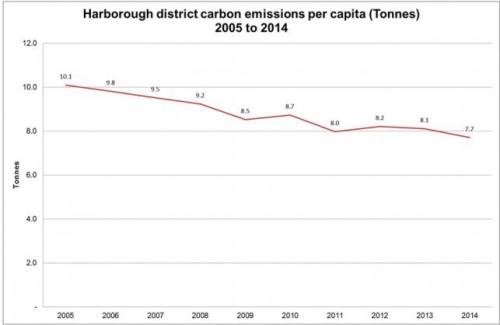
Fig.
D.7 Harborough District Carbon
Emissions Per Person
2005 to 2014
Transport is responsible for the highest proportion of the emissions, with 48.2% of the total. Domestic energy use accounts for 24.5% and industrial and commercial uses for 26.6%. Approximately 0.6% of emissions are due to agricultural land use. Please see Fig. D.8 below. (Fig. D.8)
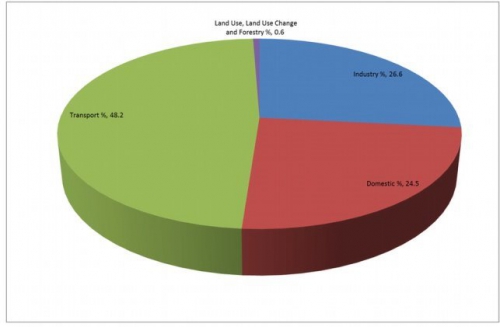
Fig.
D.8 Harborough District Carbon
Emissions by Sector
2014
Much of the District does not suffer from air quality problems. However, in the centre of Lutterworth and on the A6 in The Kibworths traffic exhaust contributes to poor air quality. This situation is being actively managed through the designation of Air Quality Monitoring Areas (AQMAs) with the associated establishment of action plans to seek improvements to the current levels.
In terms of waste reduction and recycling, the District is approaching the target to 'recycle/compost 58% of household waste by 2017', as set out in the adopted Core Strategy 2011. The overall recycling rate for Harborough in April 2014 to Mar 2015 was 57.5%.
There are several sites in the District producing significant renewable energy in 2016, and several with planning permission to do so. There are two commercial scale wind farms, Low Spinney at 8MW and Swinford at 22MW, in addition there is a further 1.2MW of wind capacity in smaller scale developments. There are three field-based solar installations with planning permission and a number of roof mounted schemes, including the photovoltaics on the Market Hall in Market Harborough. The total capacity is 6.4MW, of which 5.1MW is at domestic installations. This equates to almost half of the homes in the District being powered by renewables.
Appendix E Local Plan objectives
Table D.17 Local Plan Objectives
|
Objective |
Local Plan Policies which address this objective |
Relevant Key Issues |
Relevant Strategic Priorities |
|
1. Housing: Meet the housing requirements of the District in full by providing a range of market and affordable housing types, tenures and sizes in appropriate and sustainable locations to meet local needs. Recognise the specific accommodation requirements of the young and the elderly populations, including starter homes to help first time buyers, shared ownership and rented housing to help those who cannot afford to buy, and specialist housing such as sheltered and extra care accommodation. |
SS1: The spatial strategy, H1: Provision of new housing, H2: Affordable housing, H3: Rural exception sites, H4: Specialist housing, H5: Housing density, mix and standards, H6: Gypsy, Traveller, and Travelling Showpeople accommodation, GD2: Settlement development, GD4: New housing in the countryside, IN2: Sustainable transport, IMR1: Monitoring and review of the Local Plan, MH1: Overstone Park, MH2: East of Blackberry Grange, MH3: Burnmill Farm, L1: East of Lutterworth Strategic Development Area, SC1: Scraptoft North Strategic Development Area, F1: Land off Arnesby Road. |
2: Meeting housing needs; 10: Gypsy and Traveller and Travelling Showpeople |
SP1, SP2, SP3, SP4 |
|
2. Employment: Promote sustainable economic growth by facilitating the sustainable growth of businesses, fostering new local enterprise and helping to create more jobs that meet local employment needs. Contribute to reducing the need for out-commuting and thereby help to increase the sustainability and self-containment of communities, while encouraging the development of a vibrant, diverse and sustainable business community. |
SS1: The spatial strategy, GD2: Settlement development, GD3: Development in the countryside, BE1: Provision of new business development, BE2: Strategic distribution, BE3: Existing employment areas, BE4: Bruntingthorpe Proving Ground, BE5: Leicester Airport, Stoughton, RT1: Provision of new retail uses, RT2: Town and local centres, RT4: Tourism and leisure, HC1: Built heritage, IN2: Sustainable transport, IN3: Electronic connectivity, IMR1: Monitoring and review of the Local Plan, MH4: Land at Airfield Farm, MH5: Airfield Business Park, MH6: Compass Point Business Park, L1: East of Lutterworth Strategic Development Area, L2: Land south of Lutterworth Rd/ Coventry Rd, F2: Land off Marlborough Drive, K1: Land south and west Priory Business Park. |
3: Facilitating growth in the local economy |
SP1, SP3, SP4 |
|
3. Location of development: Locate new development in sustainable locations that respect the environmental capacity of the local area. Encourage the appropriate and efficient re-use of previously developed land and buildings where such re-use achieves the objectives of sustainable development. |
SS1: The spatial strategy, GD1: Achieving sustainable development, GD2: Settlement development, GD3: Development in the countryside, GD4: New housing in the countryside, BE4: Bruntingthorpe Proving Ground, BE5: Leicester Airport, Stoughton, H1: Provision of new housing, H5: Housing density, mix and standards, H6: Gypsy, Traveller, and Travelling Showpeople accommodation, HC2: Community facilities HC3: Public houses, post offices and village shops, GI1: Green infrastructure networks, GI2: Open space, sport and recreation, GI4: Local Green Space, GI5: Biodiversity and geodiversity, IN2: Sustainable transport, IN4: Water resources and services, IMR1: Monitoring and review of the Local Plan, L1: East of Lutterworth Strategic Development Area, SC1: Scraptoft North Strategic Development Area, MH1: Overstone Park, MH2: East of Blackberry Grange, MH3: Burnmill Farm, MH4: Land at Airfield Farm, MH5: Airfield Business Park, MH6: Compass Point Business Park, F1: Land off Arnesby Road, L2: Land south of Lutterworth Rd/ Coventry Rd, F2: Land off Marlborough Drive, K1: Land south and west Priory Business Park. |
1: The spatial strategy for distribution of housing and employment development |
SP1, SP6 |
|
4. Infrastructure: Support local communities and maintain a high quality of life by ensuring that new development delivers the necessary infrastructure including that relating to health, education, security, culture, transport, open space, recreation, water supply and treatment, power, waste and telecommunications (incorporating high speed broadband connectivity). |
SS1: The spatial strategy, HC2: Community facilities, GD2: Settlement development, GD7: Green Wedges, GI1: Green infrastructure networks, GI2: Open space, sport and recreation, GI3: Cemeteries, CC1: Mitigating climate change, CC2: Renewable energy generation, CC3: Managing flood risk, CC4: Sustainable drainage, IN1: Infrastructure provision, IN2: Sustainable transport, IN3: Electronic connectivity, IN4: Water resources and services, IMR1: Monitoring and review of the Local Plan, L1: East of Lutterworth Strategic Development Area, SC1: Scraptoft North Strategic Development Area, L2: Land south of Lutterworth Rd/ Coventry Rd, MH1: Overstone Park, MH2: East of Blackberry Grange, MH3: Burnmill Farm, MH4: Land at Airfield Farm, MH5: Airfield Business Park, MH6: Compass Point Business Park, F1: Land off Arnesby Road, Fleckney, F2: Land off Marlborough Drive, K1: Land south and west Priory Business Park. |
9: Infrastructure; 8: Transport |
SP4, SP5 |
|
5. Protection of local services: Protect, enhance and, where appropriate, secure the provision of additional accessible community services and local facilities, supporting innovation in their delivery across the District. |
SS1: The spatial strategy, GD3: Development in the countryside, HC1: Built heritage, HC2: Community facilities, HC3: Public houses, post offices and village shops, GI3: Cemeteries, IN1: Infrastructure provision, IN3: Electronic connectivity SC1: Scraptoft North Strategic Development Area, L1: East of Lutterworth Strategic Development Area, MH1: Overstone Park, MH2: East of Blackberry Grange, MH3: Burnmill Farm, F1: Land off Arnesby Road. |
7: Town centres and retail |
SP7 |
|
6. Natural environment: Protect, maintain, restore and enhance the quality, diversity, character, local distinctiveness, biodiversity and geodiversity of the natural environment, creating biodiversity and geodiversity links between terrestrial and aquatic wildlife sites ensuring that open countryside is protected against insensitive and sporadic development, the characteristics of the local landscape are respected and the unnecessary loss or sterilisation of natural resources is prevented. |
GD2: Settlement development, GD3: Development in the countryside, GD4: New housing in the countryside, GD5: Landscape and townscape character, GD6: Areas of Separation, GD7: Green Wedges, GD9: Mineral Safeguarding Areas, GI1: Green infrastructure networks, GI2: Open space, sport and recreation, GI3: Cemeteries, GI4: Local Green Space, GI5: Biodiversity and geodiversity, CC1: Mitigating climate change, CC2: Renewable energy generation, CC3: Managing flood risk, CC4: Sustainable drainage, IN1: Infrastructure provision, IN2: Sustainable transport, IN4: Water resources and services, L1: East of Lutterworth Strategic Development Area, SC1: Scraptoft North Strategic Development Area, MH1: Overstone Park, MH2: East of Blackberry Grange, MH3: Burnmill Farm, F1: Land off Arnesby Road. |
4: Development in the countryside; 5: Green infrastructure |
SP6, SP7, SP9, SP10 |
|
7. Historic environment: Protect and enhance the character and historic significance of settlements and their wider landscape and townscape settings, thereby recognising the important contribution that heritage assets and their settings make to securing a high quality public realm, whilst also maintaining the distinctiveness of towns, villages and the wider countryside. |
HC1: Built heritage, GD2: Settlement development, GD4: New housing in the countryside, GD5: Landscape and townscape character, GD6: Areas of separation, GD7: Green wedges, GD8: Good design in development, RT1: Provision of new retail uses, RT2: Town and local centres, RT3: Shop fronts and advertisements, GI3: Cemeteries, IN1: Infrastructure provision. |
1: The spatial strategy for distribution of housing and employment development |
|
|
8. Town/village centres: Support and enhance the vitality and viability of market town and larger village centres as places for shopping, leisure, cultural, commercial and community activities, thereby recognising and embracing their valued role as the hearts of their communities; this will be achieved by encouraging retail, leisure and commercial development in appropriate locations and at appropriate scales. |
SS1: The spatial strategy, GD2: Settlement development, RT1: Provision of new retail uses, RT2: Town and local centres, RT3: Shop fronts and advertisements, RT4: Tourism and leisure, HC1: Built heritage, HC2: Community facilities, HC3: Public houses, post offices and village shops, GI3: Cemeteries, IN1: Infrastructure provision, L1: East of Lutterworth Strategic Development Area, SC1: Scraptoft North Strategic Development Area, MH1: Overstone Park, MH2: East of Blackberry Grange, MH3: Burnmill Farm, F1: Land off Arnesby Road. |
7: Town centres and retail |
SP8 |
|
9. Design: Ensure that new development is of high quality and sustainable design which reflects local character and distinctiveness, provides attractive, healthy and safe environments, respects residential amenity and promotes sustainable behaviours including renewable energy technologies, waste reduction and non-motorised travel patterns. |
GD8: Good design in development, H5: Housing density, mix and standards RT1: Provision of new retail uses RT3: Shop fronts and advertisements HC1: Built heritage HC2: Community facilities, CC1: Mitigating climate change, IN3: Electronic connectivity SC1: Scraptoft North Strategic Development Area, L1: East of Lutterworth Strategic Development Area, L2: Land south of Lutterworth Rd/ Coventry Rd, MH 1: Overstone Park, MH2: East of Blackberry Grange, MH3: Burnmill Farm, MH4: Land at Airfield Farm, MH5: Airfield Business Park, MH6: Compass Point Business Park, F1: Land off Arnesby Road, F2: Land off Marlborough Drive, K1: Land south and west Priory Business Park. |
1: The spatial strategy for distribution of housing and employment development |
SP1, SP5 |
|
10. Transport: Provide greater opportunities to reduce car use, thereby reducing the impacts of road traffic on local communities, the environment and air quality, by locating development where there is good access to jobs, services and facilities, and by supporting improvements in public transport, walking and cycling networks and facilities. |
SS1: The spatial strategy, GD2: Settlement development, IN2: Sustainable transport, L1: East of Lutterworth Strategic Development Area, SC1: Scraptoft North Strategic Development Area, GD3: Development in the countryside, GD4: New Housing in the countryside, HC2: Community facilities, GI1: Green infrastructure networks, IN1: Infrastructure provision, IN2: Sustainable transport, MH 1: Overstone Park, MH2: East of Blackberry Grange, MH3: Burnmill Farm, MH4: Land at Airfield Farm, MH5: Airfield Business Park, MH6: Compass Point Business Park, L2: Land south of Lutterworth Rd/ Coventry Rd, F1: Land off Arnesby Road, F2: Land off Marlborough Drive, K1: Land south and west Priory Business Park. |
1: The spatial strategy for distribution of housing and employment development; 6: Climate Change; 8: Transport |
SP1, SP3, SP5 |
|
11. Flood risk: Locate new development in areas which will not put life or property at risk of flooding and build associated resilience by requiring the use of appropriate sustainable drainage systems in new developments and allowing for the provision of infrastructure associated with minimising flood risk, including in relation to future risk from climate change. |
CC3: Managing flood risk, CC4: Sustainable drainage, IN1: Infrastructure provision, SC1: Scraptoft North Strategic Development Area, L1: East of Lutterworth Strategic Development Area. |
1: The spatial strategy for distribution of housing and employment development; 6: Climate change |
SP9 |
|
12. Environmental impact: Minimise the environmental impact of development and its vulnerability to the impacts of climate change, by reducing pollution and waste as much as possible, maximising water and energy efficiency, and promoting the use of low carbon, renewable energy, and other alternative technologies, with sustainable construction methods. |
CC1: Mitigating climate change, CC2: Renewable energy generation, CC3: Managing flood risk, CC4: Sustainable drainage, HC1: Built heritage, GI5: Biodiversity and geodiversity, IN1: Infrastructure provision, IN2: Sustainable transport, IN4: Water resources and services, L1: East of Lutterworth Strategic Development Area, SC1: Scraptoft North Strategic Development Area, MH 1: Overstone Park, MH2: East of Blackberry Grange, MH3: Burnmill Farm, MH4: Land at Airfield Farm, MH5: Airfield Business Park, MH6: Compass Point Business Park, L2: Land south of Lutterworth Rd/ Coventry Rd, F1: Land off Arnesby Road, F2: Land off Marlborough Drive, K1: Land south and west Priory Business Park. |
6: Climate change |
SP7, SP9 |
|
13.Tourism and Culture: Promote the
sustainable growth of tourism, |
GD3: Development in the countryside, GD7: Green Wedges, RT1: Provision of new retail uses, RT2: Town and local centres, RT3: Shop fronts and advertisements, RT4: Tourism and leisure, HC1: Built heritage, HC3: Public houses, post offices and village shops, GI1: Green infrastructure networks. |
1: The spatial strategy for distribution of housing and employment development; 3: Facilitating growth in the local economy |
SP5, SP8 |
|
14: Neighbourhood Planning: Encourage and support communities to make decisions at the local level through the preparation of neighbourhood plans and facilitate this process by setting out a clear strategic framework. |
Neighbourhood plan policies should be in general conformity with all Local Plan policies, apart from: GD6: Areas of Separation, GD9: Minerals Safeguarding Areas, H3: Rural exception sites, RT3: Shopfronts and advertisements, HC2: Community facilities, HC3: Public houses, post offices and village shops, GI3: Cemeteries, GI4: Local Green Space, CC4: Sustainable drainage. |
1: The spatial strategy for distribution of housing and employment development |
SP1, SP2, Sp4, SP5, SP7, SP8, SP9, SP10 |
(6) Appendix F The settlement hierarchy
As background work to the identification of the hierarchy, settlement profiles for each of the towns and larger villages within the District have been prepared. These profiles bring together information relating to each settlement in order to understand how it functions, its key characteristics, its level of services and facilities along with any specific local issues and priorities that the community may have. Parish Councils were given the opportunity to comment on the draft profiles and their comments were incorporated where appropriate. Alongside this work an audit of the services and facilities available to all villages was carried out.
The settlement profiles and services/facilities audit work has been used to classify each settlement in a hierarchy according to its relative sustainability. Settlements at the top of the hierarchy are considered to be the most sustainable in terms of accessibility to services, facilities, shops, employment opportunities and public transport provision. These settlements are therefore the most capable of supporting further development whilst meeting the everyday needs of their residents and thus minimising the need to travel. Settlements towards the bottom of the hierarchy tend to be smaller, more rural and with very few, if any, services and facilities. These settlements are considered relatively unsustainable and therefore less suitable to accommodate future development, particularly housing.
In order to identify the most sustainable rural settlements, the number of key services accessible to the local population has been assessed. Those key services taken into account are the presence of at least two of the following: food shop, GP surgery, library, post office, primary school and public house. The existing size of the village and its relationship with other settlements has also been taken into account. In particular adjoining settlements that share a primary school within acceptable, safe walking distance have been treated as composite Selected Rural Villages (Church and East Langton, the Claybrookes, and Great Easton with Bringhurst), reflecting the guidance in paragraph 55 of the NPPF.
As the categorisation of settlements has been based on existing service provision, the level of services/facilities available to settlements will be continuously monitored. It is possible that new services, such as a local shop, could be established in a village. Any change in the level of services, which impact on the sustainability of a settlement, will form part of the considerations taken into account in a future Monitoring and review of the Local Plan and in the determination of planning applications.
The tables D.19 to D.24 below provide a summary of the settlement hierarchy. Each layer includes a definition, a list of settlements and a brief description of the approach to development.
Table D.18 Principal Urban Area (PUA)
|
Principal Urban Area (PUA) |
|
|
Definition |
Settlement forms part of the built up area of Leicester and consequently there is access to a wide range of services, facilities and employment opportunities. |
|
Settlements |
Thurnby and Bushby, Scraptoft |
|
Approach to development |
Settlements capable of sustaining expansion, infill and redevelopment on a scale which reflects their access to higher levels of employment, services and facilities. |
Table D.19 Sub Regional Centre
|
Sub Regional Centre |
|
|
Definition |
Settlement has wide range of retail, service and employment provision, good road and rail links and performs a sub regional role equivalent to other centres in the Leicester and Leicestershire Housing Market Area (HMA). |
|
Settlements |
Market Harborough |
|
Approach to development |
Settlement capable of sustaining expansion, infill and redevelopment on a scale which reflects its higher levels of employment, services and facilities and access to sustainable modes of transport. |
Table D.20 Key Centres
|
Key Centres |
|
|
Definition |
Settlement has a range of retail, service and employment and is a significant residential area. |
|
Settlements |
Lutterworth, Broughton Astley |
|
Approach to development |
Settlements capable of sustaining expansion, infill and redevelopment on a scale which reflects their good levels of services, facilities and employment. |
Table D.21 Rural Centres
|
Rural Centres |
|
|
Definition |
Rural Centres are identified on the basis of the presence of least four of the six key services (food shop, GP surgery, library, post office, primary school and pub) and a minimum of 400 households. A village's relationship with larger settlements higher up in the hierarchy has also been taken into account. Rural Centres are a sustainable location for rural housing and additional employment, retail and community uses to serve the settlement and the surrounding area. |
|
Settlements |
Billesdon, Fleckney, Great Glen, Houghton on the Hill, Husbands Bosworth, The Kibworths, Ullesthorpe |
|
Approach to development |
Settlements capable of sustaining expansion, infill and redevelopment to provide a focus for new housing and employment development in rural parts of the District on a scale which reflects their varied range of services and facilities. |
Table D.22 Selected Rural Villages
|
Selected Rural Villages |
|
|
Definition |
Selected Rural Villages are identified on the basis of presence of at least 2 of the 6 key services and a minimum of 100 households. Where neighbouring villages share a primary school which is within acceptable and safe walking distance, they have been grouped as joint Selected Rural Villages. |
|
Settlements |
Bitteswell, Church and East Langton, the Claybrookes, Dunton Bassett, Foxton, Gilmorton, Great Bowden, Great Easton (with Bringhurst), Hallaton, Lubenham, Medbourne, North Kilworth, South Kilworth, Swinford, Tilton on the Hill, Tugby. |
|
Approach to development |
Settlements suitable for rural development on a smaller scale than Rural Centres reflecting their limited services and facilities. Development should be primarily in the form of small-scale infill developments or limited extensions to help address economic, social or community objectives. This could include schemes to enable more social housing, small-scale market housing and development aimed at meeting the needs of local people. |
Table D.23 Other Villages and Rural Settlements
|
Other Villages and Rural Settlements |
|
|
Definition |
These are rural villages and settlements that do not meet the criteria for identification as Selected Rural Villages due to their size and/or level of services. |
|
Settlements |
Allexton, Arnesby, Ashby Magna, Ashby Parva, Bittesby, Blaston, Bruntingthorpe, Burton Overy, Carlton Curlieu, Catthorpe, Cold Newton, Cotesbach, Cranoe, Drayton, East Norton, Frisby, Frolesworth, Gaulby, Glen Rise, Glooston, Goadby, Gumley, Halstead, Horninghold, Hungarton, Illston on the Hill, Keyham, Kimcote, Kings Norton, Knaptoft, Laughton, Launde, Little Stretton, Loddington, Leire, Lowesby, Marefield, Misterton, Mowsley, Nevill Holt, Noseley, Newton Harcourt, Owston, Peatling Magna, Peatling Parva, Rolleston, Saddington, Shangton, Shawell, Shearsby, Skeffington, Slawston, Smeeton Westerby, Stockerston, Stonton Wyville, Stoughton, Theddingworth, Thorpe Langton, Tur Langton, Walcote, Walton, Welham, West Langton, Westerill and Starmore, Willoughby Waterleys, Wistow, Withcote. |
|
Approach to development |
Other villages and rural settlements are considered the least sustainable locations for growth and are covered by housing in the countryside policy. New housing will be limited to housing to meet an identified need (either through a housing needs survey or neighbourhood plan), housing to meet the needs of a rural worker, rural exception sites, isolated homes in the countryside in accordance with NPPF paragraph 55, and replacement dwellings. |
(3) Appendix G Housing trajectory
Table D.24 below sets out an indication of the expected rate of housing delivery throughout the plan period on a cumulative basis to provide an understanding of the delivery from capacity identified through the Local Plan process.
Table D.24 Housing trajectory
|
|
2011/ 2012 |
2012/ 2013 |
2013/ 2014 |
2014/ 2015 |
2015/ 2016 |
2016/ 2017 |
2017/ 2018 |
2018/ 2019 |
2019/ 2020 |
2020/ 2021 |
2021/ 2022 |
2022/ 2023 |
2023/ 2024 |
2024/ 2025 |
2025/ 2026 |
2026/ 2027 |
2027/ 2028 |
2028/ 2029 |
2029/ 2030 |
2030/ 2031 |
Total in Plan Period |
|
Completions |
240 |
284 |
334 |
496 |
636 |
468 |
|
|
|
|
|
|
|
|
|
|
|
|
|
|
2458 |
|
MH SDA |
|
|
|
|
|
|
36 |
46 |
116 |
131 |
120 |
120 |
120 |
120 |
120 |
120 |
120 |
120 |
120 |
84 |
1493 |
|
Allocations with PP |
|
|
|
|
|
|
107 |
47 |
|
|
|
|
|
|
|
|
|
|
|
|
154 |
|
Large Sites with PP |
|
|
|
|
|
|
278 |
274 |
244 |
273 |
280 |
200 |
100 |
99 |
100 |
50 |
|
|
|
|
1898 |
|
NP Allocations |
|
|
|
|
|
|
82 |
87 |
104 |
100 |
66 |
40 |
40 |
21 |
|
|
|
|
|
|
540 |
|
Large sites awaiting S106 |
|
|
|
|
|
|
30 |
138 |
178 |
95 |
70 |
50 |
40 |
27 |
|
|
|
|
|
|
628 |
|
Large sites approved May 2017 |
|
|
|
|
|
|
|
79 |
79 |
79 |
79 |
79 |
|
|
|
|
|
|
|
|
395 |
|
Small sites with PP |
|
|
|
|
|
|
68 |
69 |
69 |
70 |
70 |
|
|
|
|
|
|
|
|
|
346 |
|
Windfall allowance |
|
|
|
|
|
|
|
|
|
|
|
25 |
25 |
25 |
25 |
25 |
25 |
25 |
25 |
25 |
225 |
|
Total Completions, Commitments and Windfalls |
240 |
284 |
334 |
496 |
636 |
468 |
601 |
740 |
790 |
748 |
685 |
514 |
325 |
292 |
245 |
195 |
145 |
145 |
145 |
109 |
8137 |
|
Lutterworth East SDA |
|
|
|
|
|
|
|
|
|
|
|
36 |
101 |
108 |
167 |
176 |
194 |
244 |
237 |
237 |
1500 |
|
Scraptoft North SDA |
|
|
|
|
|
|
|
|
|
|
94 |
108 |
108 |
108 |
108 |
108 |
108 |
108 |
176 |
176 |
1202 |
|
Overstone Park, Market Harborough |
|
|
|
|
|
|
|
|
|
62 |
67 |
67 |
67 |
67 |
67 |
67 |
67 |
67 |
|
|
598 |
|
East of Blackberry Grange, Northampton Rd |
|
|
|
|
|
|
|
|
|
|
|
|
|
|
14 |
67 |
67 |
67 |
67 |
67 |
349 |
|
Burnmill Farm, Market Harborough |
|
|
|
|
|
|
|
|
|
|
|
23 |
67 |
|
|
|
|
|
|
|
90 |
|
South of Arnesby Rd, Fleckney |
|
|
|
|
|
|
|
|
|
|
|
|
30 |
34 |
34 |
34 |
|
|
|
|
132 |
|
Total Allocations |
0 |
0 |
0 |
0 |
0 |
0 |
0 |
0 |
0 |
64 |
159 |
234 |
373 |
315 |
391 |
452 |
436 |
486 |
480 |
480 |
3870 |
|
Total Provision on non-Allocated sites |
0 |
0 |
0 |
0 |
0 |
0 |
0 |
0 |
0 |
10 |
0 |
100 |
140 |
158 |
113 |
79 |
61 |
44 |
44 |
44 |
793 |
|
Projected Annual Total |
240 |
284 |
334 |
496 |
636 |
468 |
601 |
740 |
790 |
822 |
844 |
848 |
838 |
765 |
749 |
726 |
642 |
675 |
669 |
633 |
12800 |
(2) Appendix H Heritage assets list
The National Planning Policy Framework defines a heritage asset as "A building, monument, site, place, area or landscape identified as having a degree of significance meriting consideration in planning decisions, because of its heritage interest. Heritage asset includes designated heritage assets and assets identified by the local planning authority (including local listing)."
This list therefore features:-
1. Listed Buildings;
2. Conservation Areas;
3. Buildings at Risk;
4. Scheduled Monuments;
5. Registered Parks and Gardens; and
6. Locally-listed archaeological sites.
1. Listed Buildings
If a building is considered by the Secretary of State (for Culture, Media and Sport) to be of special architectural or historic interest it will be included in a list of such buildings. Listed buildings are classified into 3 grades:
- Grade I buildings are of exceptional interest.
- Grade II* buildings are particularly important buildings of more than special interest.
- Grade II buildings are of special interest warranting every effort to preserve them.
The District's listed buildings are not set out here because the 1,342 entries listed by Historic England may change during the period of the plan as properties are either lost or new ones added to the list. It is possible to identify whether a building is listed, and hence the description of the building and why it is listed, at the Historic England website by either:
- searching the map at https://www.historicengland.org.uk/listing/the-list/map-search?clearresults=true or
- searching by name, type, address, entry number or category at
https://www.historicengland.org.uk/listing/the-list/advanced-search?searchType=nhleadvancedsearch .
Councils may list other buildings as 'locally listed buildings'. Inclusion on such a list may result in additional guidance and control over development being available. At present there are no locally listed buildings in Harborough District.
2. Conservation Areas
Harborough has 62 designated Conservation Areas. Electronic links to their descriptions are available at http://www.harborough.gov.uk/directory/20/a_to_z and a link to the Grand Union Canal, which is separately designated, is available at https://canalrivertrust.org.uk/enjoy-the-waterways/canal-and-river-network/grand-union-canal. See table D.25 on below.
Table D.25 Conservation Areas
|
Ref. |
Conservation Area |
Ref. |
Conservation Area |
|
CA1 |
Allexton Conservation Area |
CA2 |
Arnesby Conservation Area |
|
CA3 |
Ashby Parva Conservation Area |
CA4 |
Billesdon Conservation Area |
|
CA5 |
Bitteswell Conservation Area |
CA6 |
Blaston Conservation Area |
|
CA7 |
Bringhurst Conservation Area |
CA8 |
Bruntingthorpe Conservation Area |
|
CA9 |
Burton Overy Conservation Area |
CA10 |
Carlton Curlieu Conservation Area |
|
CA11 |
Catthorpe Conservation Area |
CA12 |
Church Langton Conservation Area |
|
CA13 |
Claybrooke Parva Conservation Area |
CA14 |
Drayton Conservation Area |
|
CA15 |
East Langton Conservation Area |
CA16 |
East Norton Conservation Area |
|
CA17 |
Foxton Conservation Area |
CA18 |
Gaulby Conservation Area |
|
CA19 |
Grand Union Canal Conservation Area |
CA20 |
Great Bowden Conservation Area |
|
CA21 |
Great Easton Conservation Area |
CA22 |
Gumley Conservation Area |
|
CA23 |
Hallaton Conservation Area |
CA24 |
Horninghold Conservation Area |
|
CA25 |
Houghton on the Hill Conservation Area |
CA26 |
Hungarton Conservation Area |
|
CA27 |
Husbands Bosworth Conservation Area |
CA28 |
Illston on the Hill Conservation Area |
|
CA29 |
Keyham Conservation Area |
CA30 |
Kibworth Beauchamp Conservation Area |
|
CA31 |
Kibworth Harcourt Conservation Area |
CA32 |
Kings Norton Conservation Area |
|
CA33 |
Laughton Conservation Area |
CA34 |
Leire Conservation Area |
|
CA35 |
Loddington Conservation Area |
CA36 |
Lowesby Conservation Area |
|
CA37 |
Lubenham Conservation Area |
CA38 |
Lutterworth Conservation Area |
|
CA39 |
Market Harborough Conservation Area |
CA40 |
Medbourne Conservation Area |
|
CA41 |
Nevill Holt Conservation Area |
CA42 |
North Kilworth Conservation Area |
|
CA43 |
Owston Conservation Area |
CA44 |
Peatling Parva Conservation Area |
|
CA45 |
Rolleston Conservation Area |
CA46 |
Saddington Conservation Area |
|
CA47 |
Scraptoft Conservation Area |
CA48 |
Shawell Conservation Area |
|
CA49 |
Shearsby Conservation Area |
CA50 |
Skeffington Conservation Area |
|
CA51 |
Slawston Conservation Area |
CA52 |
Smeeton Westerby Conservation Area |
|
CA53 |
Stoughton Conservation Area |
CA54 |
Swinford Conservation Area |
|
CA55 |
Theddingworth Conservation Area |
CA56 |
Thurnby and Bushby Conservation Area |
|
CA57 |
Tilton on the Hill Conservation Area |
CA58 |
Tugby Conservation Area |
|
CA59 |
Tur Langton Conservation Area |
CA60 |
Ullesthorpe Conservation Area |
|
CA61 |
Walton Conservation Area |
CA62 |
Willoughby Waterleys Conservation Area |
3. Buildings at Risk
Historic England identifies, and places on its Heritage at Risk Register, those sites that are most at risk of being lost as a result of neglect, decay or inappropriate development. The Register is updated annually such that the current (2017) list of 6 sites in the district (below – together with links to their descriptions) may well change during the plan period.
Table D.26 Buildings at Risk
|
Ref. no. |
Address |
Hyperlink |
List Entry Number |
|
BR1 |
Church of St Thomas, Main Road, Catthorpe |
https://www.historicengland.org.uk/advice/heritage-at-risk/search-register/list-entry/1673796 |
1061441 |
|
BR2 |
Church of St Mary, Gilmorton Road, Ashby Magna |
https://www.historicengland.org.uk/advice/heritage-at-risk/search-register/list-entry/1660054 |
1061550 |
|
BR3 |
Church of St Peter, Loddington Road, Tilton on the Hill, Tilton |
https://www.historicengland.org.uk/advice/heritage-at-risk/search-register/list-entry/1671161 |
1074839 |
|
BR4 |
Church of St Thomas a Becket, Main St., Tugby and Keythorpe |
https://www.historicengland.org.uk/advice/heritage-at-risk/search-register/list-entry/1660422 |
1326673 |
|
BR5 |
Moated site at Ingarsby, Hungarton |
https://www.historicengland.org.uk/advice/heritage-at-risk/search-register/list-entry/1686836 |
1010839 |
|
BR6 |
Withcote Hall, Oakham Road, Withcote |
https://www.historicengland.org.uk/advice/heritage-at-risk/search-register/list-entry/1987353 |
1074844 |
4. Scheduled Monuments
Historic England maintains The National Heritage List for England (at https://www.historicengland.org.uk/listing/the-list/about-the-list/ ) which features all scheduled monuments, listed buildings, registered landscapes and battlefields, and protected wrecks. The listings feature on a map (at https://www.historicengland.org.uk/listing/the-list/map-search?clearresults=true ). There are 65 scheduled monuments in the district, which are listed below together with a link to the site's description.
Table D.27 Scheduled Monuments
|
Ref. no. |
Description and location |
List Entry Number |
|
SM 1 |
Roman town at High Cross, Claybrooke Magna |
1003566 |
|
SM 2 |
St Mary in Arden Church |
1003607 |
|
SM 3 |
Defended enclosure on Robin-a-Tiptoe Hill,Tilton |
1005045 |
|
SM 4 |
Kibworth Harcourt post mill |
1005061 |
|
SM 5 |
Prehistoric settlement site 800m. SW of South Kilworth village |
1005062 |
|
SM 6 |
Mound 200m. NNW of Tilton church |
1005071 |
|
SM 7 |
Site of abbey church and claustral buildings, Launde |
1005074 |
|
SM 8 |
Bridge at Medbourne |
1005080 |
|
SM 9 |
Castle mound, Launde |
1005493 |
|
SM 10 |
Bowl barrow at Misterton, Misterton with Walcote |
1008541 |
|
SM 11 |
Stormsworth deserted medieval village and fishpond, Westrill and Starmore |
1008552 |
|
SM 12 |
Whatborough deserted medieval village, Tilton |
1008555 |
|
SM 13 |
Owston Augustinian Abbey with 6 fishponds, gatehouse & boundary |
1008556 |
|
SM 14 |
Knaptoft medieval settlement and manorial complex including church, three fishponds & windmill mound |
1008817 |
|
SM 15 |
Moated site and fishponds SW of Highfields Farm. South Kilworth |
1009172 |
|
SM 16 |
Moated site and fishponds SE of St Mary's Church, Ashby Magna |
1009173 |
|
SM 17 |
Cold Newton shrunken medieval village and moated site |
1009197 |
|
SM 18 |
Moated site & deserted medieval village at Old Ingarsby, Hungarton |
1009236 |
|
SM 19 |
Moated site, enclosure and trackway at Claybrooke Parva |
1010191 |
|
SM 20 |
Moated site at Cotes de Val, Gilmorton |
1010194 |
|
SM 21 |
Stretton Magna deserted village, two fishponds & moated site, Little Stretton |
1010201 |
|
SM 22 |
Moat, fishponds & shifted village earthworks at Ullesthorpe |
1010300 |
|
SM 23 |
Sauvey Castle, Launde |
1010303 |
|
SM 24 |
Moated grange & enclosure, Owston, Owston and Newbold |
1010305 |
|
SM 25 |
North Marefield deserted medieval village and moated site, Owston and Newbold |
1010306 |
|
SM 26 |
Moated grange at Stoughton |
1010482 |
|
SM 27 |
Pinslade moated grange, Mowsley |
1010484 |
|
SM 28 |
Hallaton motte and bailey castle |
1010487 |
|
SM 29 |
Motte, moat & fishponds W of All Saints Church, Gilmorton |
1010495 |
|
SM 30 |
Moated site at Tilton |
1010704 |
|
SM 31 |
Moated site at Ingarsby, Hungarton |
1010839 |
|
SM 32 |
Moated site with fishpond at Dunton Bassett |
1010915 |
|
SM 33 |
Moated site at Allexton |
1010920 |
|
SM 34 |
Baggrave Deserted Medieval Village, Hungarton |
1012125 |
|
SM 35 |
Lowesby deserted medieval village with three fishponds |
1012438 |
|
SM 36 |
Bittesby deserted medieval village |
1012563 |
|
SM 37 |
Old Hall moated site, Lubenham |
1012566 |
|
SM 38 |
Motte in Hall Field, Kibworth Harcourt |
1012568 |
|
SM 39 |
Gumley motte castle |
1012571 |
|
SM 40 |
Market cross on west side of Market Place, Billesdon |
1014514 |
|
SM 41 |
Churchyard cross, All Saints' churchyard, Scraptoft |
1014515 |
|
SM 42 |
Churchyard cross, St Peter's churchyard, Tilton |
1014517 |
|
SM 43 |
Medieval manorial earthworks and gardens 140m south of Manor House, Tur Langton |
1017208 |
|
SM 44 |
Petlinge medieval settlement & manorial garden remains 90m west and 160m south east of All Saints' Church, Peatling Magna |
1017209 |
|
SM 45 |
Gumley medieval settlement remains, rabbit warren & field systems, 600m SW of the Church of St Helen |
1017210 |
|
SM 46 |
Gumley medieval settlement remains and field systems, 620m south east of the Church of St Helen |
1017211 |
|
SM 47 |
Petlinge medieval settlements remains 170m north of Whitehouse farm, Peatling Magna |
1017214 |
|
SM 48 |
Churchyard cross in St Michael's churchyard, Illston on the Hill |
1017489 |
|
SM 49 |
Churchyard cross in All Saints' churchyard, Peatling Magna |
1017490 |
|
SM 50 |
Churchyard cross in St Mary's churchyard, Stoughton |
1017491 |
|
SM 51 |
Churchyard cross in St John the Baptist's churchyard, Rolleston |
1017493 |
|
SM 52 |
Butter Cross 150m east of the church, Hallaton |
1017498 |
|
SM 53 |
Motte castle & associated earthwork SSW of All Saints Church, Shawell |
1017549 |
|
SM 54 |
Medieval village earthworks, fishponds & mill leat at Stonton Wyville |
1017616 |
|
SM 55 |
Monorial site west of St. Gile's Church and medieval settlement west of Manor farm, Blaston |
1018351 |
|
SM 56 |
Roman villa 200m south of Station Cottages, Cold Newton |
1018352 |
|
SM 57 |
Medieval village remains immediately south of the church, Carlton Curlieu |
1018577 |
|
SM 58 |
Medieval settlement remains 300m south east and 150m north of Wistow Hall, Wistow |
1018578 |
|
SM 59 |
Frisby medieval village remains, Frisby |
1018579 |
|
SM 60 |
Inclined plane immediately east of Foxton Locks, Foxton |
1018832 |
|
SM 61 |
Manorial site immediately south east of St Peter's Church, Arnesby |
1018833 |
|
SM 62 |
Medieval manorial fishponds at The Banks, Burton Overy |
1018835 |
|
SM 63 |
Medieval settlement remains 230m north west & 140m west of the junction of Main Street and Hothorpe Road, Theddingworth |
1018836 |
|
SM 64 |
Chapel immediately NW of Manor House, Tur Langton |
1018837 |
|
SM 65 |
Causewayed enclosure 175m west of Wheler Lodge Farm, Husbands Bosworth |
1019477 |
5. Registered Parks and Gardens
There are also 6 registered parks and gardens in Harborough district. They are identified on the map of The National Heritage List for England (at https://www.historicengland.org.uk/listing/the-list/map-search?clearresults=true ) maintained by Historic England. They are as follows with a link to the description of each:
Table D.28 Registered Parks and Gardens
|
Ref. No. |
Site |
Hyperlink |
|
RPG1 |
Baggrave |
https://www.historicengland.org.uk/listing/the-list/list-entry/1000482 |
|
RPG2 |
Lowesby |
https://www.historicengland.org.uk/listing/the-list/list-entry/1000962 |
|
RPG3 |
Quenby |
https://www.historicengland.org.uk/listing/the-list/list-entry/1000965 |
|
RPG4 |
Nevil Holt |
https://www.historicengland.org.uk/listing/the-list/list-entry/1001433 |
|
RPG5 |
West Langton |
https://www.historicengland.org.uk/listing/the-list/list-entry/1000961 |
|
RPG6 |
Stanford |
https://www.historicengland.org.uk/listing/the-list/list-entry/1000509 |
6. Locally-listed archaeological sites
Historic England maintains the PastScape database (@http://www.pastscape.org.uk/default.aspx) to provide an overview of both listed and non-listed heritage sites and places of archaeological and architectural heritage interest in England. This includes buildings, wrecks, archaeology, landscapes, investigations and aerial photograph interpretation. Some archaeological sites in the district are locally listed and through this have some level of planning protection by the council. The sites are listed below.
Table D.29 Locally-listed archaeological sites
|
Ref. No. |
Description and location |
Monument Number |
|
LL 1 |
Unidentified cropmarks, Blaston |
964592 |
|
LL 2 |
Iron Age pottery and an associated cobbled surface were found north of Watson's Acre, Blaston |
964594 |
|
LL 3 |
Six circular shallow depressions and rectilinear markings seen on aerial photographs, Carlton Curlieu |
964629 |
|
LL 4 |
Undated indefinite cropmarks, East Langton |
964691 |
|
LL 5 |
`U' rectangular, circular and other features, Gilmorton |
340289 |
|
LL 6 |
An area of disturbed ground seen on aerial photographs south of Horninghold Wood, Horninghold |
964768 |
|
LL 7 |
A cropmark of an undated rectangular depression north west of Kibworth Hall, Kibworth Harcourt |
964795 |
|
LL 8 |
Dobb Hall, undated cropmarks, possibly of modern drainage, Little Stretton |
964817 |
|
LL 9 |
Soil marks on AP - not an antiquity, Lubenham |
343897 |
|
LL 10 |
Cropmarks of `U' enclosures & possibly pits, Lutterworth |
340478 |
|
LL 11 |
Soil marks (a doubtful antiquity), Market Harborough |
343896 |
|
LL 12 |
Roman settlement site indicated by pits, ovens, post holes, gulleys, T – shaped oven and pottery, Peatling Magna |
964900 |
|
LL 13 |
Supposed Roman remains, probably incorrectly sited & confused with SP 78 NW 40, Market Harborough |
343907 |
|
LL 14 |
Soil marks seen on arial photograph, Smeeton Westerby |
342421 |
|
LL 15 |
Crop marks, Smeeton Westerby |
342427 |
|
LL 16 |
Circular soil mark, apparently post-dating ridge and furrow, seen on air photograph, Thurnby and Bushby |
965048 |
|
LL 17 |
"Prehistoric camp". Now part of SK 70 SE 13, Tilton |
321194 |
(1) Appendix I Local Green Space designations
Table D.30 Local Green Space
|
|
Location |
Reference |
Title |
|
GI4a |
Allexton |
LGS/All/1 |
Village Green, Allexton |
|
GI4b |
Arnesby |
LGS/ARN/10 |
Paddock, Stoneyleigh |
|
GI4c |
Billesdon |
LGS/Bil/2 |
Old Clay Pits Woodland, Billesdon |
|
GI4d |
Billesdon |
LGS/Bil/3 |
Muddy Lane, Billesdon |
|
GI4e |
Billesdon |
LGS/Bil/1 |
Billesdon Brook |
|
GI4f |
Burton Overy |
LGS/BO/7 |
Old Heather Garden |
|
GI4g |
Burton Overy |
LGS/BO/6 |
Traffic Island bearing the village sign |
|
GI4h |
Burton Overy |
LGS/BO/3 |
Main Street Spinney |
|
GI4i |
Burton Overy |
LGS/BO/2 |
Pasture land east of Scotland Lane |
|
GI4j |
Burton Overy |
LGS/BO/1 |
Main Street Pasture |
|
GI4k |
Bushby |
LGS/THUR/8 |
Dismantled Railway Line, Dalby Avenue |
|
GI4l |
Claybrooke Parva |
LGS/CLAPA/3 |
Church Field Ullesthorpe Road |
|
GI4m |
Dunton Bassett |
LGS/DB/c |
Wild area next to Leics. Round Footpath |
|
GI4n |
Fleckney |
LGS/FLECK/2 |
Amenity Area, Priest Meadow Estate |
|
GI4r |
Great Glen |
LGS/GRTG/1 |
Post Office Green, Great Glen |
|
GI4s |
Great Glen |
LGS/GRTG/2 |
Grassed Area Outside Chemist GG |
|
GI4t |
Keyham |
LGS/KEY/1 |
Snows Lane - Sunken Lane, Keyham |
|
GI4u |
Keyham |
LGS/KEY/2 |
Miles Piece, Keyham |
|
GI4v |
Kings Norton |
LGS/KIN/2 |
Land Adjacent to Grange Farm, Kings Norton |
|
GI4w |
Laughton |
LGS/LAUG/1 |
Village Hall green/Paddock, Laughton |
|
GI4x |
Lutterworth |
LGS/LUTT/3 |
Rye Hills, Lutterworth |
|
GI4y |
Lutterworth |
LGS/LUTT/8 |
Memorial Gardens, Lutterworth |
|
GI4z |
Lutterworth |
LGS/LUTT/5 |
River Swift Floodplain, Lutterworth |
|
GI4aa |
Medbourne |
LGS/MED/6a |
Tow Path and Gardens, Medbourne |
|
GI4bb |
Medbourne |
LGS/MED/8 |
Springbank, Medbourne |
|
GI4cc |
Medbourne |
LGS/MED/6b |
Tow Path and Gardens, Medbourne |
|
GI4dd |
North Kilworth |
LGS/NK/3 |
The Village Green, North Kilworth |
|
GI4ee |
North Kilworth |
LGS/NK/4 |
The Stoney, North Kilworth |
|
GI4ff |
Scraptoft |
LGS/SCRAP/5 |
Stocks Road, Scraptoft |
|
GI4gg |
Smeeton Westerby |
LGS/SMEW/4 |
Traffic Island, Smeeton Westerby |
|
GI4hh |
Stoughton |
LGS/STO/1 |
Paddock opp. Church Land, Stoughton |
|
GI4ii |
Stoughton |
LGS/STO/2 |
Natural recreation area, Stoughton |
|
GI4jj |
Swinford |
LGS/SWIN/1 |
Glebe Land behind Play Area, Swinford |
|
GI4kk |
Theddingworth |
LGS/THEDD/3 |
Jubilee Area, Theddingworth |
|
GI4ll |
Thurnby |
LGS/THUR/4 |
Embankments on Station Road |
|
GI4mm |
Thurnby |
LGS/THUR/1 |
Greens on front of Rose and Crown, Thurnby |
Appendix J Biodiversity and geodiversity sites
Table D.31 Sites of Special Scientific Interest
|
Ref. no. |
Name |
Main Habitat |
Size (ha) |
Condition |
|
1 |
Allexton Wood |
Broadleaved mixed and yew woodland |
25.89 |
Unfavourable recovering |
|
2 |
Cave's Inn Pit |
Neutral grassland |
5.82 |
Unfavourable recovering |
|
3 |
Chater Valley |
Neutral grassland |
3.84 |
Unfavourable recovering |
|
4 |
Eyebrook Reservoir (straddles Rutland) County |
Broadleaved mixed and yew woodland |
201.3 |
Unfavourable recovering |
|
5 |
Eyebrook Valley Woods |
Broadleaved mixed and yew woodland |
65.71 |
Unfavourable recovering |
|
6 |
Great Bowden Borrowpit |
Fen, marsh and swamp |
2.43 |
Favourable |
|
7 |
Kilby-Foxton canal (straddles Oadby and Wigston Borough) |
Standing open water and canals |
32.09 |
Unfavourable no change |
|
8 |
Launde Big Wood |
Broadleaved mixed and yew woodland |
41.16 |
Unfavourable recovering |
|
9 |
Leighfield Forest |
Broadleaved mixed and yew woodland and neutral grass land |
149.76 |
Most unfavourable recovering |
|
10 |
Misterton Marshes |
Fen, marsh and swamp and neutral grassland |
6.81 |
Unfavourable recovering |
|
11 |
Owston Wood |
Broadleaved mixed and yew woodland |
139.56 |
Unfavourable recovering |
|
12 |
Saddington Reservoir |
Fen, marsh and swamp and broadleaved mixed and yew woodland and neutral grassland |
19.08 |
Unfavourable recovering |
|
13 |
Stanford Park |
Broadleaved mixed and yew woodland |
20.44 |
Unfavourable recovering |
|
14 |
Tilton Railway Cutting |
Designated for geological assets |
4.44 |
Favourable |
For information on local sites, please see: Harborough District Council Phase 1 Habitat Survey; 2008; WYG Environment.
Appendix K Monitoring framework
Monitoring Framework
The purpose of this monitoring framework is to identify the key indicators that will be used to monitor the delivery of the Local Plan Objectives (in Section 2.3) through measuring the performance of related key policies. Although policies in the Plan will be subject to periodic monitoring where this is practicable, as referred to in the Supporting Information table for each policy, the key performance measures in the Framework will be monitored each year and the results published in the annual Authority's Monitoring Report. This is because the key indicators cited cover matters critical to the overall performance of the Plan and the delivery of sustainable development.
For each objective, except for those which refer to neighbourhood planning, an indicator with a SMART (Specific, Measurable, Achievable, Realistic and Time-Bound) target has been specified with a performance trigger level set in relation to the target. No indicator has been set for the Neighbourhood Planning Objective because the Local Plan has already fulfilled the aim to set out a clear strategic policy framework for the preparation of neighbourhood plans through the provisions of Policies SS1 The spatial strategy and H1 New housing provision
For each indicator, if the policy delivery performance against the target is at the trigger level, or worse, then a series of possible actions to remedy the poor performance will be invoked and decisions taken as to which course of action to take. However, it may be that the performance in a single monitoring year (most triggers apply annually) is atypical of a longer term trend.
Some of the trigger levels are expressly set to apply over several years or up to a particular date in the plan period. However, in any event the first consideration in assessing below target performance will be to try and identify the causes. It may be that this will reveal one-off factors that are unlikely to be repeated in future; if so no further action will be appropriate. If the recorded performance is indicative of more fundamental, ongoing problems then consideration will be given to taking the other remedial actions relevant to the indicator. The cited remedial actions are not intended to be exhaustive lists; the opportunity may arise to pursue other actions, that cannot be presently foreseen.
The selected indicators directly relate to the intended outcomes arising from the Council's use of the specified key policies, typically these outcomes will be developments granted planning permission. However it should be appreciated that the instigation of these development proposals and their subsequent implementation will, in most cases, depend on decisions taken by private developers.
Conditions in the wider national economy may, over the plan period, be such as to reduce developer profitability and/or customer demand in ways which may make the delivery of key policies particularly challenging. Nevertheless the implementation of the Local Plan is intended to be flexible with policies robust enough to be effective over changing economic conditions. The selection of remedial actions to be used will be influenced by the prevailing circumstance in the economy as a whole.
Use of the Monitoring Framework over a number of years will contribute to considerations concerning a future review of the plan as referred to in Policy IMR1 Monitoring and review of the Local Plan. Prior to then it may appropriate to produce guidance (such as Supplementary Planning Documents) on the operation of the policies. The remedial actions are listed alongside each indicator in the approximate chronological order of them being considered for use (see table D.32, starting on the next page, for more details).
APK.1 Monitoring Framework Key Indicators
Table D.32 Monitoring Framework Key Indicators
|
No. |
Objective |
Key Policy/ Policies |
Other Relevant Policies |
Key Indicator |
Target |
Risks |
Trigger |
Possible Actions to Remedy Target Not Being Met |
|
1 |
Housing |
SS1, H1 |
GD2, GD4, H2, H3, H5, H6, SC1, MH1, MH2, MH3, L1, F1 |
Amount of housing delivered. |
Delivery of housing in accordance with housing trajectory. |
|
Any significant fall below delivery of identified annual target. |
|
|
|
|
|
|
A five year deliverable supply of housing land. |
To maintain at least a five year supply throughout the remainder of the plan period. |
|
Any shortfall below a five year housing land supply. |
|
|
2 |
Employment |
SS1, BE1, BE2 |
BE3, BE4, BE5, MH4, MH5, MH6, L1, L2, F2, K1 |
Net additional floor space provided. |
At least minimum of floor space required per Use Class met in plan period. |
|
Any pro-rata cumulative shortfall of provision of more than 20% on a rolling three year average. If there are unforeseen major employment (including strategic distribution) proposals or planning approvals which are projected to have significant housing and or employment redistribution impacts on the District compared to HEDNA 2017 assumptions. |
|
|
|
|
BE2 |
|
Employment and Training Strategy secured for each proposal |
Minimum of 25% of total new jobs created filled by Harborough residents |
|
Any instance of development being contrary to policy. |
|
|
3 |
Location of development |
SS1,H1, BE1 |
GD1, H1, BE1, SC1, MH1, MH2, MH3, MH4, MH5, MH6, L1, L2, F1, F2,K1 |
Provision of housing and commercial development in Market Harborough, Lutterworth and Fleckney. |
At least dwelling completions minima met in plan period. |
|
Any pro-rata cumulative shortfall of provision of more than 20% as of 2021, 2026 and 2031. |
|
|
4 |
Infrastructure |
IN1 |
HC2, GI1, GI2, GI3, SC1, MH1, MH2, MH3, MH4, MH5, MH6, L1, L2, F1, F2, K1 |
Provision of infrastructure listed in the latest version of the Infrastructure Delivery Plan (IDP). |
Provision in line with IDP project delivery dates. |
|
Slower progress on more than 20% of infrastructure projects. |
|
|
5 |
Protection of local services |
IN1, HC2, HC3 |
N/A |
Loss of community facilities, public houses, post offices or village shops through development proposals. |
No unjustified loss. |
|
Any unjustified losses. |
|
|
6 |
Natural environment |
GI5 |
GD5, GD6, GD7, GD8, IN4 |
Net loss of any extent of a nationally or locally designated biodiversity or geodiversity asset arising from development that is permitted. |
No net loss. |
|
Any net loss. |
|
|
7 |
Historic environment |
HC1 |
GD8 |
Number of Listed Buildings and Conservation Areas on 'At Risk' Registers. |
Reduction in number by 2021, 2026 and 2031. |
|
No reduction by target years (unless number at risk is then zero). |
|
|
8 |
Town/village centres |
SS1 |
RT1, RT2, L1 |
Net additional convenience and comparison retail floor space provided at Market Harborough, Lutterworth and Broughton Astley. |
At least minimum floor space specified in Policy RT1 provided in plan period . |
|
Lack of implementation progress on less than one-third of envisaged developments by 2021 and less than two-thirds by 2026. |
|
|
9 |
Design |
GD8 |
N/A |
Design standard achieved on major developments (Annual assessment of 2-3 randomly selected major developments) against Building for Life criteria (as updated or similar standard). |
No assessed schemes with 'red light' elements granted planning permission ( a red light in the Building for Life criteria gives warning that a particular aspect of a proposed development needs to be reconsidered) |
|
Any incidents of schemes with red light elements permitted. |
|
|
10 |
Transport |
IN2 |
SS1, GD2, SC1, MH1, MH2, MH3, L1, F1 |
Proportion of major housing developments with efficient, easy and affordable access to key services (employment, education, health care and food shopping) by public transport. |
All permitted major housing developments to be no more than 400 metres from a bus stop with at least an hourly weekday service. |
|
Any permitted developments missing target. |
|
|
11 |
Flood risk |
CC3 |
CC4 |
Number of major developments permitted contrary to Environment Agency flooding advice. |
No major developments permitted contrary to Environment Agency flooding advice. |
|
Any incidence of a major development permitted contrary to advice. |
|
|
12 |
Environmental impact |
CC1 |
CC2 |
Proportion of major development proposals supported by Design and Access Statements that fully cover climate change requirements. |
All major developments permitted. |
|
Any incidence of a major development permitted contrary to the climate change requirements. |
|
|
13 |
Tourism and culture |
RT4 |
GD3 |
New tourism related development allowed within existing town centres and settlements. New appropriate tourism related development in the countryside. |
No planning permissions granted contrary to the criteria in Policy RT4. |
|
|
|
Appendix L Masterplanning requirements
Development of housing and employment sites identified in the Local Plan will be planned through a comprehensive masterplanning process proportionate to the scale of development. Preparation of masterplans will involve the active participation and input of all relevant stakeholders, including the Council, landowners, developers, the local community, service providers and other interested parties. Masterplans will be developed in consultation with the Council prior to the submission of a planning application. Where appropriate they may be adopted as Supplementary Planning Documents.
Masterplans will be expected (proportionate to the scale of development) to:
1. create a strong sense of place, ensuring the proposed development makes a positive contribution to local character and distinctiveness;
2. include an indicative housing layout and design code that reflect local distinctiveness and create a distinctive environment, incorporating landmark features or points of focus, such as public squares, pocket parks, prominent buildings, street trees and public art;
3. require high standards of urban design and architecture that respect the character of the landscape and heritage of adjacent and nearby settlements and built development;
4. plan for integrated development, providing for a mix of housing that addresses the range of local housing needs, and encourages community cohesion;
5. make effective use of the site through the application of appropriate densities in terms of scale, height and massing, and its relationship to adjoining buildings and landscape;
6. propose appropriate boundary treatment that reflects the urban to rural transition;
7. reduce the need for car use and encourage sustainable modes of travel, including provision for public transport, cycle routes, footpaths and bridleways;
8. create a network of permeable and interconnected streets and public spaces;
9. include measures to mitigate the traffic impacts of the proposed development on the strategic and local road networks;
10. provide for timely delivery of physical infrastructure, including sewage connections and fibre optic broadband;
11. ensure appropriate and timely provision of community facilities to serve the new development (e.g. local shops, community halls, schools and health facilities); and
12. include a phasing and implementation plan.
Appendix M Glossary
Table D.33 Glossary
|
Term |
Description |
|
Affordable Housing |
Housing provided to eligible households whose needs are not met by the market. This can include social rented housing (target rents determined by national rent regime) and intermediate housing (rent above social rent but below market rates). |
|
Affordable Housing Viability Assessment (AHVA) |
An assessment of the economic viability of land for housing, testing a range of percentages and thresholds of affordable housing and the impact of developer contributions. |
|
Air Quality Management Area (AQMA) |
An area where air pollutant concentrations exceed/are likely to exceed the relevant air quality objectives set by the Government. AQMAs are declared for specific pollutants and objectives. |
|
Annual Authority Monitoring Report (AMR) |
Document that assesses the extent to which the adopted Local Plan, or Core Strategy, and other local legislative policies, are being successfully implemented. |
|
Article 4 Direction |
Planning power used in exceptional circumstances by Local Authorities to protect heritage assets and their settings, such as in conservations areas, against inappropriate development under Permitted Development Rights; instead requiring planning permission to be sought. |
|
Biodiversity |
The whole variety of life encompassing all genetics, species and ecosystem variations, including plans and animals. |
|
Building Regulations |
Statutory Instruments governing the standards required for buildings. |
|
Building Research Establishment Environmental Assessment Method (BREEAM) |
BREEAM was first published by the Building Research Establishment (BRE) and is now and established method of assessing, rating and certifying the sustainability of buildings. It assesses scientifically-based criteria covering a range of issues in categories that evaluate energy and water use, health and well-being, pollution, transport, materials, waste, ecology and management processes. Buildings are rated and certified on a scale of 'Pass', 'Good', 'Very Good', 'Excellent' and 'Outstanding'. |
|
Brownfield Land and Sites |
See 'Previously Developed Land'. |
|
Building for Life Standard |
A national standard for well designed homes and neighbourhoods. |
|
Climate Change |
Long-term changes in temperature, precipitation, wind and all other aspects of the Earth's climate. Often regarded as a result of human activity and fossil fuel consumption. |
|
Coalescence |
The merging or coming together of separate towns or villages to form a single entity. |
|
Combined Heat and Power (CHP) |
The combined production of heat, usually in the form of steam, and power, usually in the form of electricity. |
|
Community Infrastructure Levy (CIL) |
A charge which aims to ensure that costs incurred in providing infrastructure to support the development of an area are partly met by land owners who have benefited from the increase in land value when planning permission is granted. |
|
Community Right to Build |
The Community Right to Build allows local communities to propose small-scale, site-specific, community-led developments. |
|
Community Owned Energy |
Communities can raise funds to develop local small scale energy generation. |
|
Conservation Area |
Areas of special architectural or historic interest, designated under the Planning (Listed Buildings and Conservation Areas) Act 1990, whose character and appearance should be preserved or enhanced. |
|
Core Strategy |
A Development Plan Document setting out the spatial vision and strategic objectives of the planning framework for an area, having regard to the Sustainable Community Strategy (see also DPDs). |
|
Corporate Strategy |
Harborough District Council's strategy covering all aspects of council operations. |
|
Contaminated Land |
Defined under the Environmental Protection Act 1990 as any land which appears to the local authority in whose area it is situated to be in such a condition, by reason of substances in, on or under the land, that (a) significant harm is being caused or there is a significant possibility of such harm being caused; or (b) significant pollution of controlled waters is being caused, or there is a significant possibility of such pollution being caused. Contamination may occur through heavy metals; oils and tars; chemical substances; gases; asbestos; radioactive substances; or can also occur naturally as a result of the geology of the area, or through agricultural use. |
|
Curtilage |
The enclosed area of land around a house or other building. |
|
Custom Build |
Dwellings designed and built for or by individuals. |
|
Density |
In the case of residential development, a measurement of either the number of habitable rooms per hectare or the number of dwellings per hectare. |
|
Design and Access Statement |
A Design and Access Statement is a concise report that explains how the proposed development is a suitable response to the site and its setting, and demonstrate that it can be adequately accessed by prospective users. |
|
Developer Contributions |
A contribution made by a developer towards local infrastructure and services to meet needs arising from the development, e.g. affordable housing, public open space and public transport provision. |
|
Development Plan Document (DPD) |
Part of the Local Development Framework. Development Plan Documents are prepared by local planning authorities and outline the key development goals of the local development framework. Development Plan Documents include the Core Strategy, Site-Specific Allocations of land and, where needed, Area Action Plans. There will also be an adopted proposals map which illustrates the spatial extent of policies that must be prepared and maintained to accompany all DPDs. All DPDs must be subject to rigorous procedures of community involvement, consultation and independent examination, and adopted after receipt of the inspector's binding report. Once adopted, development control decisions must be made in accordance with them unless material considerations indicate otherwise. |
|
District Centre |
Will usually comprise groups of shops often containing at least one supermarket or superstore, and a range of non-retail services, such as banks, building societies and restaurants, as well as local public facilities such as a library. |
|
Duty to Co-operate |
Duty to co-operate is required as some elements of planning such as the provision of infrastructure to support development, will require some form of cooperation between adjoining local authorities. The duty applies to local authorities and other public bodies involved in plan making. |
|
Elementary occupations |
Occupations which require the knowledge and experience necessary to perform mostly routine tasks, often involving the use of simple hand-held tools and, in some cases, requiring a degree of physical effort; including agriculture, process industry and construction. |
|
Employment Land Review |
A document that assesses the future demand for and supply of land for employment. |
|
Environmental Impact Assessment (EIA) |
Environmental Impact Assessment aims to provide a high level of protection of the environment and to contribute to the integration of environmental considerations into projects with a view to reduce their environmental impact. |
|
Evidence Base |
The information and data gathered by local authorities to justify the "soundness" of the policy approach set out in Local Development Documents, including physical, economic, and social characteristics of an area. |
|
Exception test |
Exception Test is a method to demonstrate and help ensure that flood risk to people and property will be managed satisfactorily, while allowing necessary development to go ahead in situations where suitable sites at lower risk of flooding are not available. |
|
Functional Economic Market Area (FEMA) |
The functional area over which the local economy and its key markets operate. Key economic markets broadly correspond to sub-regions or city regions - known as functional economic market areas (FEMAs). |
|
Five Year Supply |
Five year supply is calculated from the objectively assessed need and the housing land availability. To maintain a five year supply there must be enough land to meet the housing needs as laid out by the OAN figure. |
|
Flood Plain |
Land adjacent to a watercourse over which water flows, or would flow in times of flood, but for the defences in place. |
|
Flood Risk Assessment (FRA) |
Flood Risk Assessment identifies all the sources of flood risk on a site and the impact it has beyond, and identifies appropriate mitigations. |
|
Flood Zone 1 |
Low probability: Land having a less than 1 in 1,000 annual probability of river or sea flooding. Development sites in Flood Zone 1 that are over 1 hectare in size still require a flood risk assessment to assess potential impact on other areas downstream. |
|
Flood Zone 2 |
Medium probability: Land having between a 1 in 100 and 1 in 1,000 annual probability of river flooding; or land having between a 1 in 200 and 1 in 1,000 annual probability of sea flooding. |
|
Flood Zone 3a |
High probability: Land having a 1 in 100 or greater annual probability of river flooding; or land having a 1 in 200 or greater annual probability of sea flooding. |
|
Flood Zone 3b |
The functional floodplain: This zone comprises land where water has to flow or be stored in times of flood. Local planning authorities should identify in their Strategic Flood Risk Assessments (SFRAs) areas of functional floodplain and its boundaries accordingly, in agreement with the Environment Agency. |
|
General Employment Area (GEA) |
An existing office park, industrial estate, or larger individual employment site sites generally fit for purpose for business use but may benefit from upgrade or renewal. |
|
Geodiversity |
Geodiversity incorporates all the variety of rocks, minerals and landforms and the processes which have formed these features throughout geological time. |
|
Green Corridor / Wildlife Corridor/ Greenway |
Green corridors can link housing areas to the national cycle network, town and city centres, places of employment and community facilities. They help to promote environmentally sustainable forms of transport such as walking and cycling within urban areas and can also act as vital linkages for wildlife dispersal between wetlands and the countryside. |
|
Green Infrastructure (GI) |
The open environment within urban areas, the urban fringe and the countryside which comprises of a network of connected, high quality, multi-functional open spaces, corridors and the links in between that provide multiple benefits for people and wildlife. |
|
Green Wedge |
Green Wedges comprise the open areas around and between parts of settlements, which maintain the distinction between the countryside and built up areas, prevent the coalescence (merging) of adjacent places and can also provide recreational opportunities. |
|
Greenfield Land and Sites |
Sites which have not been previously developed (e.g. agricultural land, parks, recreation grounds and allotments). |
|
Groundwater Source Protection Zones (SPZ) |
SPZs are used to define areas close to drinking water sources where the risk associated with groundwater contamination is greatest. They are not statutory designations but do relate to distances and zones defined in legislation where certain activities are restricted. |
|
Gypsy and Traveller Accommodation Assessment (GTAA) |
An assessment looking into detailed information about local Gypsies and Travellers which aims to generate reliable estimates of future accommodation. |
|
Home Quality Mark (HQM) |
The Home Quality Mark (HQM) is a national standard for new homes, which uses a simple 5-star rating to provide impartial information from independent experts on a new home's design, construction quality and running costs. |
|
Homes and Communities Agency (HCA) |
The Homes and Communities Agency (HCA) help create successful communities by making more homes and business premises available to the residents and businesses who need them. The HCA also regulate social housing providers in England. |
|
Housing and Economic Development Needs Assessment (HEDNA) |
Report produced for the Leicester and Leicestershire Housing Market Area (HMA) to identify the required housing and employment growth for each Local Authority Area. |
|
Housing Market Area (HMA) |
The administrative area covered by the City Council and the District Councils in Leicestershire make up the HMA. |
|
Infrastructure |
Basic services necessary for development to take place, for example, roads, electricity, sewerage, water, education and health facilities. |
|
Key Centre |
A key centre is a settlement with a broad range of services, including doctors, schools (including secondary schools), shops and community facilities. |
|
Key Diagram |
Diagram setting out the broad spatial locations of development within the Local Plan. |
|
Key Employment Area |
An existing office park, industrial estate, or larger individual employment site of significance for future business use, that will be protected for employment generating use. |
|
Landscape Character Assessment (LCA) |
An assessment which identifies different landscape areas which have a distinct character based on a recognisable pattern of elements, including combinations of geology, landform, soils, vegetation, land use and human settlement. |
|
Listed Building |
A building of special architectural or historic interest. Listed buildings are graded I, II* or II with grade I being the highest. Listing includes the interior as well as the exterior of the building, and any buildings or permanent structures within the curtilage of the Listed Building (e.g. wells within its curtilage). |
|
Leicester and Leicestershire Enterprise Partnership (LLEP) |
Local Enterprise Partnerships were set up as part of the Localism Act 2011 to drive economic development. |
|
Local Centre |
Include a range of small shops of a local nature, serving a small catchment. Typically local centres might include, amongst other shops, a small supermarket, a newsagent, a sub-post office and a pharmacy. In rural areas, large villages may perform the role of a local centre. |
|
Local Development Scheme (LDS) |
The local planning authority's three year programme and timetable for the preparation of Local Development Documents. |
|
Local Nature Reserve (LNR) |
Local Nature Reserve is a publicly accessible area controlled and designated by a Local Authority as an area important for wildlife. |
|
Local Green Space |
Local Green Space designation is a way to provide special protection against development for green areas of particular importance to local communities. |
|
Local Transport Plan (LTP) |
Sets out Leicestershire County Council's local transport strategies and policies, and an implementation programme. |
|
Local Wildlife Site (LWS) |
Local Wildlife Sites are identified and selected locally using robust, scientifically-determined criteria and detailed ecological surveys. |
|
Localism Act 2011 |
The Localism Act 2011 is an Act of Parliament that changes the powers of local government in England. The aim of the act is to facilitate the devolution of decision-making powers from central government control local communities. |
|
Major Development |
The Government defines major development in terms of a planning application as more than 10 dwellings or site over 0.5 ha. For all other uses floorspace over 1000sq.m or site area over 1 ha. |
|
Masterplan |
A document that sets out the broad development proposals for a site or area. |
|
Mixed Use Development |
Mixed-use development is a type of urban development that blends residential, commercial, cultural, institutional, or industrial uses, where those functions are physically and functionally integrated, and that provides pedestrian connections. |
|
National Planning Policy Framework (NPPF) |
The NPPF acts as guidance for local planning authorities and decision-takers, both in drawing up plans and making decisions about planning applications. |
|
Neighbourhood Development Plans (NDP) |
Neighbourhood Development Plans, introduced in the Localism Act 2011, become part of the Local Plan and the policies contained within them are then used in the determination of planning applications. Plans are "made" following an examination by a Planning Inspector and a referendum of the local community. |
|
Non-strategic Storage and Distribution |
Commercial buildings in B8 Class Storage and Distribution use (often referred to as warehouses) as defined by the Town and Country (Use Classes) Order 1987 (as amended) where the individual unit size is 9,000sq.m. gross floor-space or below. |
|
Objectively Assessed Need (OAN) |
Objectively Assessed Need (OAN), is an assessment of housing and economic development need during a plan period based on evidence, which is not constrained by policy considerations. It is derived from a range of evidence, including population, household and economic growth projections. |
|
Open Space |
All space of public value, including public landscaped areas, playing fields, parks and play areas, and also including not just land, but also areas of water such as rivers, canals, lakes and reservoirs, which can offer opportunities for sport and recreation or can also act as a visual amenity and a haven for wildlife. |
|
Out-commuting |
The act of residents of Harborough District travelling out of the district for work. |
|
Outline Planning Permission |
This type of planning application allows fewer details about the proposal to be submitted. These details may be agreed following a "reserved matters" application at a later stage. |
|
Passive design |
Passive design relies on using natural light and warmth from the sun to warm and light a building. In general the building would not require a heating or cooling system. |
|
Passivhaus |
The heating requirement in a Passivhaus is reduced to the point where a traditional heating system is no longer considered essential. Cooling is also minimised by the same principles and through the use of shading and in some cases via the pre-cooling of the supply air. |
|
Permitted Development Rights (PDR) |
Where the need for planning permission is removed, subject to Local Authority conditions and the terms set out in the Town and Country Planning Act, 1990. |
|
Pitch |
Area of land on a Gypsy and Traveller caravan site developed for a single family (a group of related people who live and/or travel together - assumed to be the basic unit when assessing accommodation requirements). A single pitch will often need to contain more than one caravan. |
|
Planning Condition |
Conditions can enhance the quality of development and enable development proposals to proceed where it would otherwise have been necessary to refuse planning permission. |
|
Planning Policy Statement (PPS) |
Issued by central government to replace the existing Planning Policy Guidance notes in order to provide greater clarity and to remove from national policy advice on practical implementation, which is better expressed as guidance rather than policy. |
|
Planning for Climate Change Study |
A study commissioned jointly by Harborough and other local authorities in order to underpin future planning policies relating to climate change. |
|
Policies Map |
District maps with spatial Local Plan policies displayed. |
|
Previously Development Land (PDL) or Brownfield Land |
Previously developed land is that which is or was occupied by a permanent structure (excluding agricultural or forestry buildings), and associated fixed-surface infrastructure. The definition covers the curtilage of the development. Planning Policy Statement 3 (Housing) has a detailed definition. |
|
Principal Urban Area (PUA) |
The main settlement, in this case Leicester, which has the highest level of services, including retail, hospitals, employment and higher education. |
|
Registered Social Landlord (RSL) |
A provider of low cost market housing for rent or sale which is accessible to people on low incomes and below the minimum cost of local market housing. Typically these are Housing Associations and Councils. |
|
Renewable Energy |
Energy that is derived from a source that does not run out. These include solar, wind, wave, hydro and biomass. |
|
Rural Centre |
A large village with a range of four out of six services, including a primary school, shop, post office, library, GP Surgery or pub. |
|
Rural Exception Site/ Policy |
A development plan or Development Plan Document may allocate small sites within rural areas solely for affordable housing, which would not otherwise be released for general market housing. |
|
Scheduled Monument (SM) |
Nationally important monuments usually archaeological remains, that enjoy greater protection against inappropriate development through the Ancient Monuments and Archaeological Areas Act 1979. |
|
Section 106 Agreement |
A legal agreement under section 106 of the 1990 Town and Country Planning Act. Section 106 agreements are legal agreements between a planning authority and a developer, or undertakings offered unilaterally by a developer, that ensure that certain extra works related to a development are undertaken. |
|
Secured by design |
Policy initiative to inform development design to reduce the opportunities for crime and to include the best practice in security features. |
|
Selected Rural Village (SRV) |
A village with at least two of the six key services, including a primary school, shop, post office, library, GP Surgery or pub. |
|
Sequential Test |
A test that development to sites in a specific order e.g. for flooding development is directed first to low flood risk areas; for retail development is directed to town centres first. |
|
Site of Special Scientific Interest (SSSI) |
A site identified under the Wildlife and Countryside Act 1981 (as amended by the Countryside and Rights of Way Act, 2000) as an area of special interest by reason of any of its flora, fauna, geological or physio graphical features (basically, plants, animals, and natural features relating to the Earth's structure). |
|
Socially rented housing |
Socially rented housing is a form of 'affordable housing'. It is owned by local authorities and private registered providers for which guideline target rents are determined through the national rent regime. It may also be owned by other persons and provided under equivalent rental arrangements to the above, as agreed with the local authority or with the Homes and Communities Agency. |
|
Spatial Planning |
Spatial planning goes beyond traditional land use planning to bring together and integrate policies for the development and use of land with other policies and programmes which influence the nature of places and how they function. This will include policies which can impact on land use by influencing the demands on, or needs for, development, but which are not capable of being delivered solely or mainly through the granting or refusal of planning permission and which may be implemented by other means. |
|
Starter Homes |
In the March 2016 Technical Consultation, the Government's statutory definition of a Starter Home: 'a new dwelling only available for purchase by qualifying first-time buyers and which is made available at price which is at least 20% less than its market value but which is below the price cap. A price cap of £250,000 outside Greater London and £450,000 in Greater London is specified in the Bill. The clause also sets out the criteria which a person must fulfil to be eligible to purchase a starter home. These include that the purchaser is a first-time buyer (falling within the statutory definition) and that he or she is under the age of 40.' |
|
Strategic Economic Plan (SEP) |
An overarching economic growth strategy, prepared by a Local Enterprise Partnership for its geographic area. |
|
Strategic Flood Risk Assessment (SFRA) |
A Strategic Flood Risk Assessment is a study carried out by one or more local planning authorities to assess the risk to an area from flooding from all sources, now and in the future, taking account of the impacts of climate change, and to assess the impact that land use changes and development in the area will have on flood risk. |
|
Strategic Housing Land Availability Assessment (SHLAA) |
A document that identifies sites and assesses their potential for housing and when they are likely to be developed. |
|
Strategic Housing Market Assessment (SHMA) |
An assessment of housing need and demand which is carried out on the basis of sub-regional housing market areas. |
|
Strategic Growth Plan |
A non statutory, long term over-arching plan which sets out the aspirations for delivering growth. Acts as a strategic planning framework for an area, meaning local authorities take the plan into account when developing their Local Plans. |
|
Strategic Storage and Distribution |
Commercial buildings in B8 Class Storage and Distribution use (often referred to as warehouses) as defined by the Town and Country (Use Classes) Order 1987 (as amended) where the individual unit size is over 9,000sq.m. (or approximately 100,000sq.ft.), this being a standard recognised definition within the commercial property sector. |
|
Statement of Community involvement (SCI) |
Document setting out when, with whom and how consultation will be undertaken on Local Development Documents. |
|
Sub-regional Centre |
The main settlement in an area, usually a small town with fewer services than nearby cities, but with a good range of services. |
|
Superfast Leicestershire |
Superfast Leicestershire is a project to bring fibre broadband to as many premises in Leicestershire as possible. It is a partnership between the County Council, BT, the District and Borough Councils, economic bodies, and voluntary and charity organisations who want to achieve this. |
|
Supplementary Planning Document (SPD) |
A Supplementary Planning Document is a Local Development Document that may cover a range of issues, thematic or site specific, and provides further detail of policies and proposals in a 'parent' Development Plan Document. |
|
Sustainability Appraisal (SA) |
A process by which the economic, social and environmental impacts of a project, strategy or plan are assessed. The aim of the appraisal process is to minimise adverse impacts and resolve as far as possible conflicting or contradictory outcomes of the plan or strategy. |
|
Sustainable Development |
A widely used definition drawn up by the World Commission on Environment and Development in 1987: "Development that meets the needs of the present without compromising the ability of future generations to meet their own needs." The government has set out four aims for sustainable development in its strategy A Better Quality of Life, a Strategy for Sustainable Development in the UK. The four aims, to be achieved simultaneously, are:
|
|
Sustainable Drainage Systems (SuDS) |
Sustainable drainage systems are designed to control surface water run off close to where it falls and mimic natural drainage as closely as possible. They provide opportunities to:
|
|
Town Centre |
Usually the 2nd level of centres after city centres and, in many cases, they will be the principal centre in a Local Authority's area. In rural areas they are likely to be market towns and other centres of similar size and role which function as important service centres, providing a range of facilities and service for extensive rural catchment areas. |
|
Travel Plan |
A travel plan aims to promote sustainable travel choices (for example, cycling) as an alternative to single occupancy car journeys that may impact negatively on the environment, congestion and road safety. Travel plans can be required when granting planning permission for new developments. Sometimes called 'Green Travel Plans'. |
|
Urban Fringe |
The urban fringe is the transitional area between urban areas and the countryside. It can provide a valuable resource for the provision of sport and recreation, particularly in situations where there is an absence of land within urban areas to meet provision. |
|
Use Class Order |
The Town and Country Planning (Use Classes Order),1987, as amended, specifies various classes of use for buildings or land. Within each class the use for another purpose of the same class does not require planning permission. |
|
Village Design Statements |
Village Design Statements are a form of planning guidance that informs the visual character of new development in a village to maintain the character of the village. They are developed by the village community. |
|
Water Framework Directive (WFD) |
The Water Framework Directive directs that development and agriculture should not impact upon water quality in rivers, steams and lakes. Where possible quality should be improved by controlling run-off. |
|
Water Stress |
Water stress occurs when demand for drinking water is high, or projected to grow significantly, and the amount of rainfall is insufficient to meet demand. |
|
Windfall Development Sites |
Sites which have not been specifically identified as available in the Local Plan process. They normally comprise previously-developed sites that have unexpectedly become available. |