Great Easton Conservation Area Appraisal
8.0 Assessment of Special Interest
8.1 Great Easton has a wide variety of buildings. The older houses are mostly on the lower ground to the south and west of the church. There are two triangular greens, one immediately south of the churchyard and one further south where the three principal roads meet and the War Memorial is situated. The majority of the older ironstone houses occur round the two greens, in Barnsdale, and in the lanes near the stream on the west side of the village.
8.2 Much of the special architectural interest in Great Easton has been nationally recognised through the Grade II* listing of St Andrew's Church and the Grade II listing awarded to 46 other heritage assets within the conservation area boundary (see Appendix A for full details).
8.3 Special interest in a conservation area is not only formed by the buildings but also the spaces between them and other features of interest. These can include the settlement layout, green infrastructure, open spaces, views and public realm.
8.4 Entering the conservation area from Stockerston Lane the open countryside gives way to twentieth-century ribbon development. Lounts Crescent forks to the left and Broadgate turns to the right. Three pairs of Council houses were built in Stockerston Lane soon after the First World War and four pairs in Broadgate after the Second World War. Five pairs in Lounts Crescent were completed in 1952. They are all typical examples of type for the date of construction and show the development of the village in the first half of the twentieth century. In general, the front gardens have been retained and the vegetation within them contributes to the natural environment within the conservation area.
8.5 At the junction with Broadgate there is a small triangular green, behind which is 48 High Street, a double-fronted Victorian house. Overlooking the green and facing down Broadgate it makes a positive contribution to this part of the conservation area which has a more twentieth century suburban character. The thatched mud and wattle cottages in the image below, from around 1910, have now all been replaced with twentieth century brick houses and bungalows and the road is to modern standards with pavements, but the prominence of 48 High Street in the street scene remains.
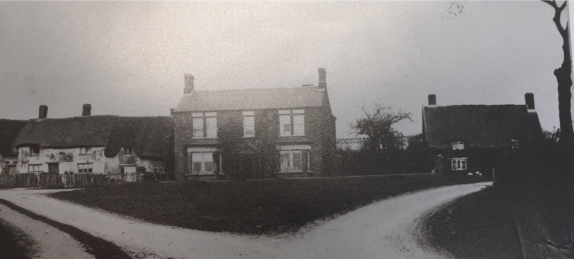
Fig. 6 Circa 1910 view up Broadgate to the junction with High Street where 48 High Street overlooks the green. (Great Easton & District Local History Society Archive).
8.6 In general roads in Great Easton do not have continuous pavement on both sides of the road. Where pavements do exist, they are often only on one side of the road. This is particularly true of High Street where there is pavement on one side with a strip of the village green extending down the other side of the road. High Street contains a number of ironstone buildings (many of which are nationally listed) which front directly on to the road so the combination of the honey-coloured stone and neat green with its shrubs and trees contribute to the rural character of High Street.
8.7 The Grade II listed buildings in High Street include Holme Leigh House which is built in a manner characteristic of the Welland Valley using alternate bands of ironstone and limestone. It is the largest surviving seventeenth century house in the conservation area. Like several of the older houses, the gable end of Holme Leigh House is set onto the street, suggesting that the street front was already crowded. Located behind the green on High Street and standing in its own grounds is the Old Rectory. This is a Grade II listed building which was originally a seventeenth century farmhouse that was enlarged in the eighteenth century when it became the Vicarage. Opposite on the other side of the road is the Grade II Granby House. The current building dates from the late nineteenth century although the building was first licensed as a public house in 1753. It was the Marquis of Granby public house until 1914. One of the larger outbuildings was even used for village dances and similar events prior to the village hall, so it has played an important part in village life.
Fig. 7. View down the High Street showing the green and variety of properties fronting the opposite.side of the street. The image also shows how chimneys feature strongly throughout the conservation area.
8.8 The current Village Hall is further along High Street. It not only makes a positive contribution to the conservation area but it has contributed to village life for many years. In keeping with the agricultural history of Great Easton the building's origins are agricultural and it would have originally been thatched. It was sold by local farmer, Tom Mould, in 1933 to provide a meeting place for the local lodge of the Ancient Order of Oddfellows. It was used for village events and celebrations even before it was purchased by the Parish Council in 1954. The building was extended in 1982/3 and the corrugated roof replaced in 1987. This is where residents have celebrated local and national events including Royal Jubilees and Coronations. The building and the field behind it were the hub for the archaeological team of during the 2003 Time Team television programme.
8.9 Further along High Street sees the introduction of Victorian brick buildings. Opposite the Old Bake House (Grade II listed as Stone Walls) and the listed K6 telephone kiosk is the former Wesleyan Chapel. It was built, adjacent to the village pound, using Great Easton bricks and the date stone in the gable shows 1857. The chapel closed in 1986 and was turned into residential use, the pound became the parking area for the property. The gable of the chapel is distinctive in the street scene on the descent into the village down High Street and Church Bank. The former chapel and the pound both played an important role in village life and they are a positive contribution to the conservation area.
8.10 Church Bank leads off High Street and up towards St Andrew's Church. It provides a fine vista up to the church and its spire. The Clock House on Church Bank is a double-fronted brick building with a date stone showing 1881. The clock set between the upper and lower windows to the left of the house gives the house its name. Adjoining the left side of the house is the original clockmaker's workshop. The building makes a positive contribution to the conservation area and shows an aspect of the nineteenth century industrial history of the village.
Fig. 8. Clock House on Church Hill with the workshop attached.
8.11 A little further up the hill is an intimate enclosed green on Church Bank which opens out upwards to the church and churchyard. From the far corner of the green a road leads behind the church down to the farmhouse of Rectory Farm, a working farm at the heart of the village. There are several listed buildings clustered around the green, including 6 Church Bank which dates from the 1500s and is one of the buildings in the conservation area still to contain evidence of its original cruck structure. It was the Crown Inn from 1753 to 1909. At the centre of the green is one of the former village water pumps along with seating where it is possible to sit and take in the rural tranquillity of Great Easton and its wider countryside setting (see Fig. 2 in Section 5).
Fig. 9. View of the green on Church Bank with the water pump and seating area. 6 Church Bank can be seen behind the green to the right of the image.
8.12 Between the former Wesleyan Chapel on High Street and the Grade II former Post Office is a stretch of mud wall running along the High Street. The varied walls of Great Easton add much to the village character and with its location on the High Street this stretch is a good example of the positive contribution the walls make to the conservation area.
Fig.10. Stretch of mud wall on High Street.
8.13 Two other Victorian brick buildings which make a positive contribution to the conservation area are located at 12 and 13 Cross Bank, overlooking the War Memorial. They are both built with the gable end onto the street and have a polychromatic detail at the top of the gable. They are solid examples of their building type, more often found in urban settings, and unusual to find in the local area. Polychromatic brick also features on the former butcher's shop (Grade II listed as LC Ellingworth, Butcher) on the opposite side of the road at 16 Cross Bank. Hidden behind 16 Cross bank, and now in residential use, is the former slaughterhouse to the butchers which is another building that once played an important part in village life.
8.14 There are several listed buildings situated around the junction of the War Memorial, including The Sun Inn. This is now a gastro pub which attracts custom from a wide area, many of whom travel by car. The first recorded landlord of the premises was in 1753, although the present building has had nineteenth and twentieth century additions. Opposite The Sun Inn on the north side of Cross Bank is an attractive terrace of two-storey ironstone cottages. In this terrace is 9 Cross Bank, which has a wide archway with double gates leading to the rear of the property. This archway may be evidence that the building was originally built as an alehouse. From the late 1700s until 1958 it was The Shoulder of Mutton public house. It did not have a cellar or a bar, so the beer was kept on tap in barrels at the rear of the building and customers were served from there.
8.15 Cross Bank leads into Caldecott Road where the conservation area boundary ends just after number 28 and the road extends into open countryside. The road contains predominantly stone houses, cottages and outbuildings with some later additions towards the edge of the village. Behind a stone wall on the south side of Caldecott Road is a small burial ground which makes a positive contribution to the conservation area. The burial ground, containing five graves, was originally next to an Independent (Congregational) chapel. This was demolished around 1919 but remaining stones from the building are visible adjacent to the gate post. Although close to the passing traffic on the Caldecott Road it is a quiet, well maintained, place for people to sit on the bench and enjoy the rural surroundings. Stones from the demolished chapel were incorporated into the garden wall of the former manor house, Greylands, (now 1 Caldecott Road) on the opposite side of the road. This is a large ironstone house, dated 1615, set in large grounds. Although considerably altered prior to the First World War, it remains a fine building which contributes to the character of the conservation area. The side elevation fronts Caldecott Road and the front elevation looks to the conservation area boundary and out to the open countryside beyond.
Fig. 11. Front elevation of 1 Caldecott Road which looks out of the conservation area towards Caldecott.
8.16 Next to The Sun Inn on Cross Bank is a detached brick 1960s house and garage, set back behind a small hedge and mature front garden. It was built by Mr Wallace, who it is said later regretted his actions. However, it is a good example of this age and style of housing and confidently takes its places amongst the ironstone buildings and Victorian brick buildings, situated around the War Memorial junction, which illustrate the changes in building over the centuries as Great Easton developed. Opposite is the former Moore and Haddon corset factory, now in residential use. The building was converted from agricultural use in 1908 and produced corsets until it closed in 1963, so it was an important part of the industrial life of Great Easton.
8.17 Leading off Cross Bank is Banbury Lane, formerly School Lane. The houses on Banbury Lane closest to Cross Bank are stone built but there is modern infill development of brick houses and bungalows further down the lane. Although they do not reflect the materials generally used in the conservation area, these buildings are well set back and do not impact on the view down Banbury Lane towards the large house at number 11 (Grade II listed) that marks the end of the lane and the conservation area boundary. 11 Banbury Lane is one of several properties in the conservation area that contain a blank wall tablet, the reason for which is unknown. 2 Banbury Lane is a two-storey ironstone cottage of seventeenth century origins with later additions in brick. Prior to the opening of the Board School at Bringhurst in 1874, village children were taught at 2 Banbury Lane. When the building was sold in 1924 the walls were built up in brick and the roof raised as the building was then used as a Reading Room until around 1945.
8.18 The junction of Barnsdale and Brook Lane is a particularly attractive vista. With the grouping of its ironstone barns and cottages the view along Barnsdale to the conservation area boundary is particularly picturesque. This is reflected in the number of listed buildings in Barnsdale, some of which contain evidence of the early use of crucks in their construction. The first thatched ironstone building is 8 Barnsdale (Grade II listed), which is now in residential use but served as the Kings Head Inn from 1818 to 1914 when it then became a shop. The ironstone cottages front the road, which is in contrast to Deepdale house which is set back from the road in its garden. Deepdale House (Grade II listed) on the southern side of Barnsdale is the last property before the conservation area boundary. It is a distinctive early nineteenth-century square building, with a fine ashlar frontage facing outwards along the road, looking towards Bringhurst, rather than fronting on to Barnsdale. It was the home of the local doctor for over 100 years.
Fig. 12 View along Barnsdale from the junction with Brook Lane.
8.19 Just prior to Barnsdale House is the modern development of Castle Lane. Although local materials have been used for the development, it has more of a modern suburban character to the lane. However, the properties do not front Barnsdale and are set back so do not significantly impact the vista along Barnsdale or detract from the quality of the conservation area. The land behind Barnsdale that was clearly open space in the 1960s aerial photograph of Great Easton (see Fig. 4. in Section 7) was developed in the early 2000s. Local materials have been used in the construction of the properties, but they still have more of a modern suburban character. Although they are located within the conservation area boundary, access is via Clarkes Dale and they are largely hidden behind Barnsdale so they do not detract from the character of the conservation area.
Fig. 13. Castle Lane has a more suburban character with hardstanding separated by hedging.
8.20 Opposite Church Lane is Furleigh Cottage (Grade II listed). It is a fifteenth century thatched cottage which carries a small plaque marking the impact of twentieth century history on Great Easton. The plaque remembers Joseph Craythorne who lived at Furleigh cottage prior to his death in France during the First World War. Although the names of all the men of Great Easton who died in the two World Wars are on the War Memorial, recognition of their former homes highlights how small agricultural communities were touched by international events. This is especially so in Barnsdale as the adjacent cottage has a plaque remembering Harold Baker who died in 1917.
8.21 The triangular green at the junction of Barnsdale and Brook Lane is planted with spring bulbs and contains a village sign erected for the Golden Jubilee of Queen Elizabth the Second. Overlooking the green is 2 Barnsdale, one of the former bakehouses in the village. It was once two cottages, but one was demolished, and a taller Victorian stone addition was built onto the existing cottage. The datestone to this addition is 1879. The stone also contains the initials JC for John Culpin the baker. The property is located at a prominent junction and makes a positive contribution to the conservation area.
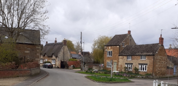
Fig. 14. The former bakehouse at the triangular green at the junction of Barnsdale and Brook Lane.
8.22 Brook Lane is a mixture of old houses (a number of which are listed at Grade II) intermingled with more modern properties which generally do not reflect the local materials and rural character of the conservation area.. The properties closest to the junction with Barnsdale are stone built larger properties like the Grade II listed Westbrook House. The brook and the stretch of grass and vegetation running alongside Brook Lane contributes to the tranquil rural character of the conservation area. With the brook running alongside the road it is necessary for properties to be set further back and consequently the vegetation of the front gardens contributes to the natural environment within the conservation area. The open space between High Street and Brook Lane also makes a positive contribution to the conservation area.
8.23 On the corner of Brook Lane and Mould's Lane is 24 Brook Lane which is one of the smaller listed buildings in the lane. It is a modest dwelling which would have been home to a farm labourer rather than an employer. It would have originally been thatched, but it currently has a corrugated roof which was a common material to use when owners were unable to afford to replace the thatch. Beyond this point the rest of Brook Lane is late twentieth century bungalows and more modern housing. The properties are set back from the road with front gardens which contribute to the natural environment within the conservation area, however, their material palette is not in keeping with the rest of Brook Lane and they are much more suburban in character.
Fig. 15. View along Brook Lane to the junction with Barnsdale where the canted bay window of 1 Barnsdale is visible.
8.24 Brook Lane runs into Pitchers Lane, which is again a combination of old and more modern buildings of the type in Brook Lane. Number 4 Pitchers Lane is a typical seventeenth century cross passage house. During restoration work in 1989 fragments of a cruck were found which may indicate the building has sixteenth century origins. At the end of Pitchers Lane is the junction with Deepdale to the left and Broadgate to the right.
8.25 Entering Deepdale the properties are of a modern construction in a range of materials. Further into Deepdale, towards the brook at the end, the suburban character gives way to a rural character more fitting of the conservation area. There is a row of Victorian Cottages built using Great Easton brick in 1860. Along from the cottages is a sensitively designed twenty-first century home which fits well in the setting. Across the brook is the Grade II listed Brook House which is a large seventeenth century house set in grounds which extend to the boundary of the conservation area.
8.26 Broadgate is largely suburban in character with the houses and bungalows being of late twentieth century design and layout. The exception is the two Grade II listed buildings at 16 and 22 Broadgate. Number 16 Broadgate is a small seventeenth century house while Broadgate House at number 22 is a large house dating from around 1720-1750. Being one of the older houses in the village it is unusual that one chimney is on the rear elevation of the house rather than the normal gable stack. For a period during the nineteenth century part of this building was The Bell public house.
8.27 Opposite Broadgate House is the 1970s development of Musk Close. The houses in Musk Close are typical of the design and layout used in such developments at the time and there is no attempt to reflect local materials. Although it has a very suburban feel, it is possible to see the surrounding trees and to glimpse the church spire from Musk Close as a reminder of its village location. The cul-de-sac is a well-kept and good example of its type for the period. It nestles behind Broadgate and the houses and bungalows are all set back behind open plan front gardens. The gardens now contain mature trees and shrubs which softens the hard landscaping of the cul-de-sac.
Fig. 16. The design and layout of Musk Close with the surrounding trees of the conservation area.
8.28 Although the design and materials used for the twentieth century additions in the north-western side of the conservation area have not generally reflected the rural character of the conservation area the integrity for the conservation area remains intact.