Great Easton Conservation Area Appraisal
5.0 Character Location and Uses
5.1 Great Easton is located amid attractive countryside in the south east of Leicestershire, close to the boarders of Rutland and Northamptonshire. It lies in the Welland Valley and is 22 miles south east of Leicester and 9 miles north east of Market Harborough. The Eyebrook Reservoir is a mile north of the village. Great Easton is one of the larger villages of the Welland Valley. It is compact in shape around a rectangle of roads, linked through by jitties (alleyways). In addition, there are three roads to adjacent villages with lanes or jitties leading outwards. The Conservation Area embraces all these roads with the exception of Clarkes Dale and Barnsdale Close, the 1960s housing development at the southern entrance to the village, and Stokes Rise, which leads off Broadgate in the north west of the conservation area.
5.2 From a distance the size of the village is obscured, as most of it lies in the low flat land of the Welland Valley. The spire of the Grade II* Church of St. Andrew stands up above the village trees and glimpses of it can be seen at points throughout the conservation area. The ironstone Church itself is on an eminence some 15 metres higher than the nodes at either end of Cross Bank. This is in keeping with the High Leicestershire settlement pattern of 'buildings clustered around prominent spired churches of limestone or ironstone'.[1]
5.3 Great Easton is a traditional farming village with a working farm (Rectory Farm) still at the heart of the village. Much of its historic character comes from the relationship of farms and fields to the housing and other buildings which form the settlement. The farmsteads and former farmsteads are characteristic of the village with many former outbuildings now re-purposed for residential use. Some of the street names in the village also reflect the integral role of farming, with Musk Close being named after the Musk family, upon whose paddock it was built, and Mould's Lane which refers to the Mould family who farmed in Great Easton and built Mould's Cottages for their workers in 1913. The tranquil nature of the village is periodically disturbed by farm traffic, which is to be expected with a working farm just behind the church.
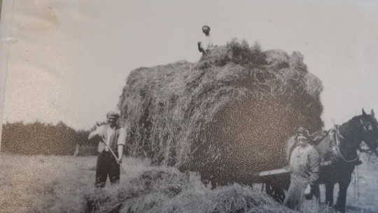
Fig. 1. Mr Mould's farm workers circa 1930 (Great Easton & District Local History Society Archive)
5.4 The prominent building material of Great Easton is ironstone with roof materials of thatch, or of Collyweston slate, or of Welsh slate. Chimneys are also a prominent feature in the conservation area. Some buildings show a characteristic local feature of the Welland Valley of striped stonework in alternating bands of brown ironstone and Weldon stone. Some subsidiary outbuildings within the village retain pink corrugated pantiles. This combination of materials led the historian W.G. Hoskins to describe Great Easton as 'the most attractive village in Leicestershire to look at, with its groups of fine ironstone farm-houses, manor-houses and cottages nearly all built in the first half of the seventeenth century'.[2] The quality of the historic built environment in Great Easton is recognized with 47 nationally listed assets (see Appendix A). Larger houses and cottages are located away from the principal roads up smaller lanes such as Banbury Lane, Deepdale or Little London.
5.5 The varied walls of Great Easton are an interesting feature adding much to the village scene and character; they are of mud, stone or red brick. They have a great variety of copings including stone, pantiles, rounded terra cotta and blue saddle copings. Walking down the jitty of Mould's Lane (which links High Street and Brook Lane) it is possible to see walls in all these materials.
5.6 Referred to as 'the village field' during the Time Team excavations, the open space between High Street and Brook Lane makes a positive contribution to the conservation area and has been open space to the rear of the street frontage since medieval times. As the number of open spaces between and behind the roads and jitties has reduced, that which remains has great value to the character and appearance of the conservation area.
5.7 In September 2023 the village shop and post office closed and a farm shop opened at Rectory Farm. The shop on High Street was near to the bus stop and it attracted vehicular and pedestrian traffic bringing life to the village. It is too early to see the impact of the location of the new farm shop. The Sun Inn on Cross Bank also attracts residents and visitors during the lunchtime and evenings as do regular meetings and events in the village hall.
5.8 Entering the conservation area from the north west on Stockerston Lane, the open countryside gives way to twentieth-century ribbon development. Lounts Crescent forks to the left and Broadgate turns to the right. A small number of pairs of Council houses were built in Stockerston Lane, Broadgate and Lounts Crescent between the 1920s and the 1950s. The north western end of the Conservation Area has infill of various closes or of ribbon development within the village pattern. Otherwise the settlement pattern is of sporadic lining of the principal roads by farm buildings, cottages or larger houses with large gardens. The road continues into High Street which contains a number of fine ironstone buildings, many of which front the road.
5.9 The number of roads and jitties together with the numerous traditional stone buildings gives rise to many attractive groupings and vistas. These include Barnsdale, with the triangular junction of Barnsdale, Brook Lane with a stream running alongside, and Cross Bank; the two triangles in the High Street, one with the small green and War Memorial at the south, the other at the bifurcation of High Street and Church Bank having a Grade II listed K6 red telephone box at the apex. The vista up Church Bank to the church with its spire is especially fine. Between the telephone box and the church is an intimate enclosed green on Church Bank which opens out upwards to the church and churchyard. On this green is a water pump next to a bench where it is possible to rest and take in the rural tranquillity. A little further up the hill, just outside the entrance to the churchyard, is another bench from which there is a panoramic view across open countryside towards Rockingham Castle.
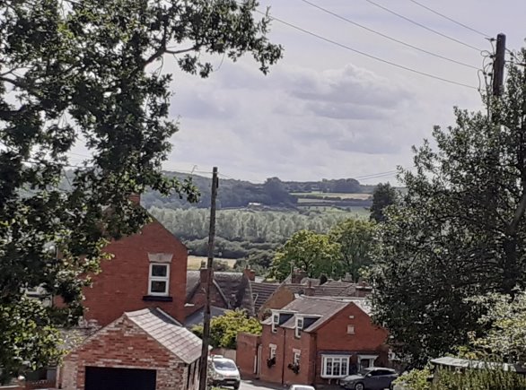
Fig. 2. View from the top of Church Bank out to the surrounding countryside.
5.10 Entering the Conservation Area from each of the two southern roads is marked by a notable early nineteenth century building, facing outwards along the road, rather than fronting the road. On Barnsdale, Barnsdale House looking towards Bringhurst, and on Caldecott Road No. 28 Caldecott Road looking towards Caldecott.
[1] Natural England, National Character Area Profile 93: High Leicesterhire, (2013), p. 9.
[2] W. G. Hoskins, Touring Leicestershire, (1948), p. 22.