Bitteswell Conservation Area
7.0 Historic Development of the Area
7.1 Excavations within the Parish of Bitteswell with Bittesby have revealed pieces of flint, sherds of Iron Age, Roman and Medieval pottery which all point to the long history of the area. With Bitteswell's close proximity to the High Cross, the point where the Roman roads of Watling Street and the Fosse Way crossed, it is not surprising that excavations at West End Farm in 2019 discovered several Roman ditches and gullies. The 4th Century Roman pottery, animal bones and Roman brick discovered, all provide evidence of Roman activity within the conservation area and demonstrate Bitteswell's long history.
7.2 In the 8th Century Bitteswell was recorded as being within the Saxon Kingdon of Mercia and was part of the Guthlaxton Wapentake. Cultivation has taken place around Bitteswell since Saxon times, when the greens at the centre of the village would have provided secure grazing for sheep and cattle.
7.3 There is reference to Bitteswell, as 'Betmeswelle', (broad valley spring) in the Doomsday Book of 1086. It has been a continuously occupied settlement since this entry.
7.4 The 12th Century church has been at the heart of the settlement throughout its development. The first vicar of 'Betmeswelle' was Jordan in 1220 and subsequent vicars are listed in the church until 1989. The north transept was added to the church in 1852 by W Parsons and further alterations were made by Walter F. Lyon in 1881-2. Lord Denbigh was the titular Lord of the Manor, but residency was never established.
7.5 In 1630 the parish of Bitteswell recorded 38 families. The Grade II listed Dunlis House, located towards the western end of the village greens, is a half-timbered property which, in places, dates from circa 1540, although the majority is seventeenth century which was extended in the early nineteenth century.
7.6 By 1760 the Lutterworth to Ullesthorpe road was part of the national road network of turnpikes initiated by George III. With extensive grazing and fresh spring water the village provided facilities for changing and resting horses. Tollgate Cottage at the eastern boundary of the conservation area and the Grade II listed Turnpike Lodge at the western end of the village greens both link Bitteswell to its heyday when stage coaches and the mail coach all passed through the village on the way to and from London and Chester or Holyhead. Published in 1848, the image below shows Tollgate Cottage where coaches stopped to pay the levy and pass through the turnpike gate to enter Bitteswell.
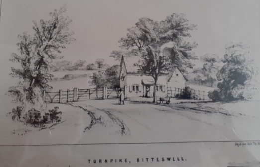
Record Office for Leicestershire, Leicester and Rutland DE3736 – image copied from 'Bitteswell' (1848).
7.7 Following the Enclosure Act passed in 1773, the open and common fields and pastures of Bitteswell were enclosed in 1787. Enclosure brought to an end the open field farming system and divided the open fields into the patchwork of fields and hedges we recognise today. Evidence of the medieval open field arable farming system used prior to enclosure can still be seen in the ridge and furrow earthworks in fields within the locality, including those behind Valley Lane which lie within the conservation area boundary.
7.8 By 1801 the Return to Parliament showed that the population of Bitteswell had risen to 69 families dwelling in 68 properties, giving a total population of 398 (192 males, 206 females). Within a decade this had risen to 88 properties occupied by 94 families. The agricultural history of Bitteswell is evident in that 61 of the 94 families residing in Bitteswell in 1811 were chiefly employed in agriculture. Both the growth of the settlement and its agricultural heritage are reflected in a number of late eighteenth and early nineteenth century buildings (now Grade II listed) such as the farmhouses of West End Farm and Green Farm on The Green and Valley Farm on Valley Lane. Valley Farmhouse is now known as Dowell House as it was the home of the Dowell family until 1936. A century on from the 1811 census, the image below from circa 1910 shows the continued role of agriculture with hay making in Bitteswell.
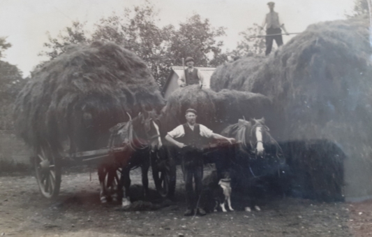
Hay making in Bitteswell circa 1910 (Record Office for Leicestershire, Leicester and Rutland: DE 3736).
7.9 In 1789 Reverend James Powell became vicar of St Mary's Church. He served in this role until his death in 1844. Reverend Powell was married to the daughter of the tea merchant Richard Twinning (1749-1824). The impact of Reverend Powell and his relatives on the historic built environment of Bitteswell can still be evidenced today. This is most prominent in the Grade II listed Almshouses of Powell Row, built in the centre of the village greens in 1847 and in the lychgate to St Mary's Church which was erected by Richard Twinning in 1888 in memory of Reverend Powell. Just outside the conservation area boundary on Ullesthorpe Road is a cemetery which is an extension of the churchyard of St Mary's Church. This is recognised as an important open space within the Bitteswell Neighbourhood Plan (Pre-submission version, February 2021). The land was a gift from Richard Twinning and was consecrated in 1902.
7.10 The 1800s was a period of change for Bitteswell. Pigot's Directory of 1822 lists a boarding school for boys in Bitteswell. The advert for which mentioned daily coaches to London. However, the frequency of stage coaches passing through Bitteswell declined with the construction of the Midland Railway in Ullesthorpe in 1840. Before his death Reverend Powell founded The Boys Free School which opened in 1844 and was funded by the late vicar and his sister. This was replaced by a mixed Public Elementary School in 1871 and the Old School House became a private residence. In 1838 Bitteswell Hall was built approximately a mile from the village. This was a mansion set in extensive landscaped parklands with an ornamental lake and fox covert as well as its own farms and kitchen garden. The construction of such a large estate may have accounted for the population increasing to 495 in 1841. Two other large houses with wooded gardens had been built within the village in the first half of the nineteenth century – the Manor House on Lutterworth Road (re-built in 1938 in a French-villa style) and Bitteswell House on Valley Lane. With the building of The Lodge and two cottages (now Russett Cottage) on The Nook and the location of the Almshouses in the centre of the village green, the street plan and significant heritage assets of the conservation area can be identified in the Bitteswell map of 1887 (below). The open spacious nature of the conservation area and the relationship to the open countryside surrounding it is also evident.
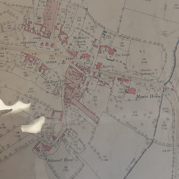
Map of Bitteswell 1887 (Record Office for Leicestershire, Leicester and Rutland).
7.11 By 1931 the population of Bitteswell had fallen to 293. The demolition of Bitteswell Hall in 1928 and the increasing use of modern farming methods may have been responsible for this reduction. In 1940 RAF Bitteswell was constructed close to the village in the south of the parish. From 1943 to 1987 the area was also home to a Hawker Siddeley factory which assembled and tested aircraft. In the 1980s this became the Magna Park distribution centre. By 1951 the population of Bitteswell had increased to 346. From the 1962 map below it is clear to see that Bitteswell is developing with housing extending west on the Ullesthorpe Road and away from the village core down Ashby Lane. It also shows twentieth century development commencing down Valley Lane.
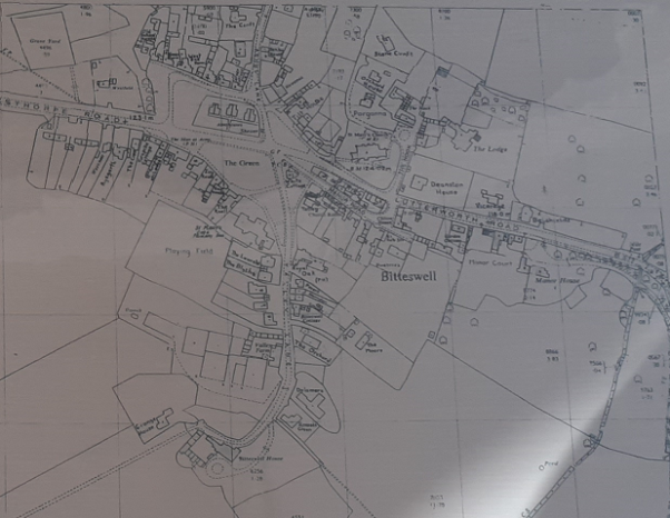
1962 Map of Bitteswell (Record Office for Leicestershire, Leicester and Rutland)
7.12 In the 60 years since the 1962 map development has continued down Ashby Lane and Ullesthorpe Road, new properties have been built behind Green Farmhouse and the Old School House at the western end of the village, and considerable development has taken place in Valley Lane. The 2011 census recorded 554 residents living in 199 households.